
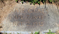
Dovie Stott Gaines
| Birth | : | 7 Apr 1893 Montford Cove Township, Rutherford County, North Carolina, USA |
| Death | : | 2 Oct 1935 Morganton, Burke County, North Carolina, USA |
| Burial | : | Montford Cove Baptist Church Cemetery, Union Mills, Rutherford County, USA |
| Coordinate | : | 35.5244110, -82.0934540 |
| Description | : | Death certificate gives date of death as November 2, 1935. Dovie married M.J. Gaines Jan 2, 1933 in Marion, McDowell County. He was sixteen years her senior. She died less than two years later of Pellagra, of which dementia is a symptom, thereby explaining her place of death at the State Hospital in Morganton. |
frequently asked questions (FAQ):
-
Where is Dovie Stott Gaines's memorial?
Dovie Stott Gaines's memorial is located at: Montford Cove Baptist Church Cemetery, Union Mills, Rutherford County, USA.
-
When did Dovie Stott Gaines death?
Dovie Stott Gaines death on 2 Oct 1935 in Morganton, Burke County, North Carolina, USA
-
Where are the coordinates of the Dovie Stott Gaines's memorial?
Latitude: 35.5244110
Longitude: -82.0934540
Family Members:
Parent
Siblings
Flowers:


Nearby Cemetories:
1. Hemphill Morgan Cemetery
Rutherford County, USA
Coordinate: 35.5197250, -82.0914320
2. Welcome Home Baptist Church Cemetery
Gilkey, Rutherford County, USA
Coordinate: 35.5118310, -82.0482780
3. Cedar Creek Holiness Church Cemetery
Bills Creek, Rutherford County, USA
Coordinate: 35.4855560, -82.1106620
4. Antioch Church Cemetery
Bills Creek, Rutherford County, USA
Coordinate: 35.4826780, -82.1201230
5. Dalton Family Cemetery
Bills Creek, Rutherford County, USA
Coordinate: 35.4826320, -82.1391050
6. Shingle Hollow Holiness Church Cemetery
Rutherfordton, Rutherford County, USA
Coordinate: 35.4700130, -82.0727290
7. Old Pleasant Grove Methodist Church Cemetery
McDowell County, USA
Coordinate: 35.5785060, -82.0515210
8. Noblitt Graveyard
McDowell County, USA
Coordinate: 35.5690890, -82.1534230
9. Piney Knob Baptist Church Cemetery
Rutherfordton, Rutherford County, USA
Coordinate: 35.4633100, -82.0551600
10. Davistown Cemetery
Old Fort, McDowell County, USA
Coordinate: 35.5661011, -82.1632996
11. Freedom Missionary Baptist Church Cemetery
McDowell County, USA
Coordinate: 35.5835400, -82.0412400
12. Pleasant Grove Cemetery
Marion, McDowell County, USA
Coordinate: 35.5830920, -82.0399750
13. Sugar Hill Baptist Church Cemetery
McDowell County, USA
Coordinate: 35.5803070, -82.0316050
14. Hillsdale Church Cemetery
Rutherfordton, Rutherford County, USA
Coordinate: 35.4849150, -82.0134380
15. Saint Johns Missionary Baptist Cemetery
Lake Lure, Rutherford County, USA
Coordinate: 35.4523926, -82.1266098
16. Lawing Cemetery
McDowell County, USA
Coordinate: 35.5628014, -82.0056000
17. Gossett Family Cemetery
Rutherfordton, Rutherford County, USA
Coordinate: 35.4439400, -82.0766300
18. Pine Ridge Mennonite Church Cemetery
Rutherfordton, Rutherford County, USA
Coordinate: 35.4568660, -82.0358090
19. Mountain Creek Independent Baptist Church Cemetery
Glenwood, McDowell County, USA
Coordinate: 35.5657700, -82.0057900
20. Bethlehem Community Cemetery
Old Fort, McDowell County, USA
Coordinate: 35.6009320, -82.1315530
21. Bills Creek Baptist Church Cemetery
Bills Creek, Rutherford County, USA
Coordinate: 35.4514980, -82.1411210
22. Pleasant Grove Baptist Church Cemetery
Rutherfordton, Rutherford County, USA
Coordinate: 35.4436000, -82.0646970
23. Sigmon - Laughter Family Cemetery
Oldfort, Polk County, USA
Coordinate: 35.6020486, -82.1359261
24. Mount Nebo Baptist Cemetery
Lake Lure, Rutherford County, USA
Coordinate: 35.4502700, -82.1500200