
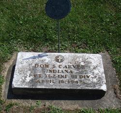
Dow Stafford Carver
| Birth | : | 7 Aug 1894 Wabash, Wabash County, Indiana, USA |
| Death | : | 16 Apr 1942 Wabash, Wabash County, Indiana, USA |
| Burial | : | Immaculate Conception Cemetery, Bellevue, Huron County, USA |
| Coordinate | : | 41.2664500, -82.8340630 |
| Plot | : | Sec L, lot 35, sp 1 |
| Inscription | : | Indiana Private 362nd Infantry 91st Division |
| Description | : | Married Martha L. Hall on 12 June 1920 in Grant County, Indiana. They divorced. OBITUARY - Plain Dealer, Wabash (IN) Dow S. Carver, 48, died Thursday in his home on South Miami street after an extended illness, having been critically ill for the last three months. The body was removed to the Wire Funeral home where friends may call. Services will be held Sunday afternoon at 2:30 o'clock in the funeral home with R.D. Wise, pastor of the Wesleyan Methodist Church officiating, assisted by the Rev. Wilbur Way of Peru. Dow Stafford Carver was born Aug. 7, 1893 in Wabash county to Milton... Read More |
frequently asked questions (FAQ):
-
Where is Dow Stafford Carver's memorial?
Dow Stafford Carver's memorial is located at: Immaculate Conception Cemetery, Bellevue, Huron County, USA.
-
When did Dow Stafford Carver death?
Dow Stafford Carver death on 16 Apr 1942 in Wabash, Wabash County, Indiana, USA
-
Where are the coordinates of the Dow Stafford Carver's memorial?
Latitude: 41.2664500
Longitude: -82.8340630
Family Members:
Parent
Spouse
Siblings


Nearby Cemetories:
1. Immaculate Conception Cemetery
Bellevue, Huron County, USA
Coordinate: 41.2664500, -82.8340630
2. Bellevue Cemetery
Bellevue, Huron County, USA
Coordinate: 41.2658005, -82.8368988
3. Saint Paul United Church of Christ Cemetery
Bellevue, Sandusky County, USA
Coordinate: 41.2703270, -82.8485000
4. Saint Pauls German Lutheran Cemetery
Lyme Township, Huron County, USA
Coordinate: 41.2268600, -82.8172600
5. Strongs Ridge Cemetery
Strongs Ridge, Huron County, USA
Coordinate: 41.2833290, -82.7830582
6. Trinity Episcopal Cemetery
Bellevue, Huron County, USA
Coordinate: 41.2633150, -82.7768610
7. York Free Chapel Cemetery
York, Sandusky County, USA
Coordinate: 41.2803100, -82.8982300
8. Bishop Seybert Cemetery
Flat Rock, Seneca County, USA
Coordinate: 41.2257996, -82.8739014
9. Avery Cemetery
Clyde, Sandusky County, USA
Coordinate: 41.3207290, -82.8499700
10. Gilbert Cemetery
Clyde, Sandusky County, USA
Coordinate: 41.2778015, -82.9186020
11. Underhill Cemetery
Seneca County, USA
Coordinate: 41.2098030, -82.8758530
12. Fireside Cemetery
Seneca County, USA
Coordinate: 41.2270000, -82.9072100
13. Wales Corners Cemetery
Clyde, Sandusky County, USA
Coordinate: 41.3166885, -82.9018860
14. Saint Michaels Cemetery
Frank, Seneca County, USA
Coordinate: 41.1927986, -82.8514023
15. Thompson Center Cemetery
Seneca County, USA
Coordinate: 41.2117004, -82.9024963
16. Hunts Corners Cemetery
Hunts Corners, Huron County, USA
Coordinate: 41.2203800, -82.7539700
17. Deyo Cemetery
Groton Township, Erie County, USA
Coordinate: 41.3428001, -82.8332977
18. Lyme Cemetery
Monroeville, Huron County, USA
Coordinate: 41.2313995, -82.7403030
19. Jones Cemetery
Sherman Township, Huron County, USA
Coordinate: 41.1864400, -82.8063500
20. North Monroeville Cemetery
Monroeville, Huron County, USA
Coordinate: 41.2842200, -82.7248900
21. Ellsworth Cemetery
Clyde, Sandusky County, USA
Coordinate: 41.3293991, -82.9269028
22. Parkhurst Cemetery
Clyde, Sandusky County, USA
Coordinate: 41.3561550, -82.8732740
23. Keegan Farm Cemetery
Clyde, Sandusky County, USA
Coordinate: 41.3659610, -82.8574340
24. Tew Cemetery
Clyde, Sandusky County, USA
Coordinate: 41.3675003, -82.8569031