
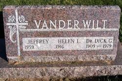
Dr Dirk G. “Dick” Vander Wilt
| Birth | : | 5 Mar 1909 Middleburg, Sioux County, Iowa, USA |
| Death | : | 17 Jul 1979 Salt Lake City, Salt Lake County, Utah, USA |
| Burial | : | Denton Cemetery, Denton, Metropolitan Borough of Tameside, England |
| Coordinate | : | 53.4424140, -2.1115510 |
| Plot | : | North Section, Row 17 |
| Description | : | Dr. Dick G. Vander Wilt, 70, of Salt Lake City, Utah, formerly of Orange City, and Sibley, died Tuesday, July 17, at Salt Lake City of long illness. Services were at 2 p.m. Thursday, in the Free Grace Reformed Church at Middleburg, north of Orange City. The Rev. Henry Bovendam officiated. Burial was in the Middleburg Cemetery under the direction of Van Etten-Oolman Funeral Home of Orange City. Mr. Vander Wilt was born March 5, 1909, near Orange City. He married Helen Reyelts in January of 1943 at Omaha. After serving in the United States Army during World War II, he practiced dentistry... Read More |
frequently asked questions (FAQ):
-
Where is Dr Dirk G. “Dick” Vander Wilt's memorial?
Dr Dirk G. “Dick” Vander Wilt's memorial is located at: Denton Cemetery, Denton, Metropolitan Borough of Tameside, England.
-
When did Dr Dirk G. “Dick” Vander Wilt death?
Dr Dirk G. “Dick” Vander Wilt death on 17 Jul 1979 in Salt Lake City, Salt Lake County, Utah, USA
-
Where are the coordinates of the Dr Dirk G. “Dick” Vander Wilt's memorial?
Latitude: 53.4424140
Longitude: -2.1115510
Family Members:
Parent

Spouse
Siblings
Flowers:


Nearby Cemetories:
1. Denton Cemetery
Denton, Metropolitan Borough of Tameside, England
Coordinate: 53.4424140, -2.1115510
2. St Lawrence Church
Denton, Metropolitan Borough of Tameside, England
Coordinate: 53.4520000, -2.1109000
3. Christ Church Churchyard
Denton, Metropolitan Borough of Tameside, England
Coordinate: 53.4560270, -2.1218270
4. Saint Mark Churchyard
Bredbury, Metropolitan Borough of Stockport, England
Coordinate: 53.4241160, -2.1051390
5. St George Churchyard
Hyde, Metropolitan Borough of Tameside, England
Coordinate: 53.4466540, -2.0789750
6. Audenshaw Cemetery
Audenshaw, Metropolitan Borough of Tameside, England
Coordinate: 53.4653300, -2.1101560
7. Hyde Chapel Chapelyard
Gee Cross, Metropolitan Borough of Tameside, England
Coordinate: 53.4374900, -2.0728100
8. Hyde Cemetery
Hyde, Metropolitan Borough of Tameside, England
Coordinate: 53.4437910, -2.0684130
9. Saint Thomas The Apostle Churchyard
Hyde, Metropolitan Borough of Tameside, England
Coordinate: 53.4509000, -2.0707000
10. Holy Trinity Churchyard
Gee Cross, Metropolitan Borough of Tameside, England
Coordinate: 53.4393900, -2.0645500
11. Willow Grove Cemetery
Stockport, Metropolitan Borough of Stockport, England
Coordinate: 53.4252900, -2.1508100
12. Highfield Cemetery
Bredbury, Metropolitan Borough of Stockport, England
Coordinate: 53.4133310, -2.1111320
13. St. John The Baptist Churchyard
Hyde, Metropolitan Borough of Tameside, England
Coordinate: 53.4548411, -2.0644712
14. St Elisabeth Church
Reddish, Metropolitan Borough of Stockport, England
Coordinate: 53.4379400, -2.1633950
15. Saint Chad's Churchyard
Romiley, Metropolitan Borough of Stockport, England
Coordinate: 53.4128520, -2.0896350
16. Hatherlow Chapel Cemetery
Bredbury, Metropolitan Borough of Stockport, England
Coordinate: 53.4109259, -2.0992592
17. Hatherlow United Reformed Church Cemetery
Romiley, Metropolitan Borough of Stockport, England
Coordinate: 53.4107180, -2.0989830
18. Saint Stephens Churchyard
Audenshaw, Metropolitan Borough of Tameside, England
Coordinate: 53.4753000, -2.1151700
19. Gorton Cemetery
Manchester, Metropolitan Borough of Manchester, England
Coordinate: 53.4567080, -2.1632580
20. St Mary's Churchyard
Hyde, Metropolitan Borough of Tameside, England
Coordinate: 53.4652400, -2.0599700
21. Dukinfield Cemetery and Crematorium
Dukinfield, Metropolitan Borough of Tameside, England
Coordinate: 53.4800300, -2.0857150
22. The Parish Church of Saint Peter
Stockport, Metropolitan Borough of Stockport, England
Coordinate: 53.4084880, -2.1492930
23. St. Mary's Churchyard
Stockport, Metropolitan Borough of Stockport, England
Coordinate: 53.4112340, -2.1555140
24. St. Paul's Churchyard
Portwood, Metropolitan Borough of Stockport, England
Coordinate: 53.4215604, -2.1717953