
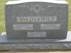
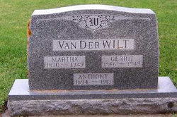
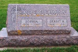
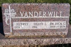
Anthony Vander Wilt
| Birth | : | 1894 Iowa, USA |
| Death | : | 1913 Iowa, USA |
| Burial | : | Euxton Parish Churchyard, Euxton, Chorley Borough, England |
| Coordinate | : | 53.6650950, -2.6743630 |
| Plot | : | South Section, Row 3 |
frequently asked questions (FAQ):
-
Where is Anthony Vander Wilt's memorial?
Anthony Vander Wilt's memorial is located at: Euxton Parish Churchyard, Euxton, Chorley Borough, England.
-
When did Anthony Vander Wilt death?
Anthony Vander Wilt death on 1913 in Iowa, USA
-
Where are the coordinates of the Anthony Vander Wilt's memorial?
Latitude: 53.6650950
Longitude: -2.6743630
Family Members:
Parent

Siblings
Flowers:


Nearby Cemetories:
1. Euxton Parish Churchyard
Euxton, Chorley Borough, England
Coordinate: 53.6650950, -2.6743630
2. St. Mary's Churchyard
Euxton, Chorley Borough, England
Coordinate: 53.6669580, -2.6768350
3. Charnock Richard Crematorium
Chorley, Chorley Borough, England
Coordinate: 53.6518550, -2.6763080
4. Chorley Cemetery
Chorley, Chorley Borough, England
Coordinate: 53.6549770, -2.6447530
5. Saint Andrews Churchyard
Leyland, South Ribble Borough, England
Coordinate: 53.6881270, -2.6957880
6. St Laurence's Church
Chorley, Chorley Borough, England
Coordinate: 53.6546880, -2.6327020
7. St Mary's Roman Catholic Churchyard
Leyland, South Ribble Borough, England
Coordinate: 53.6880510, -2.6983240
8. Christ Church
Charnock Richard, Chorley Borough, England
Coordinate: 53.6367200, -2.6773400
9. St George's Churchyard
Chorley, Chorley Borough, England
Coordinate: 53.6521460, -2.6295520
10. St Peters Churchyard
Chorley, Chorley Borough, England
Coordinate: 53.6607430, -2.6232100
11. St John the Evangelist Churchyard
Whittle-le-Woods, Chorley Borough, England
Coordinate: 53.6883280, -2.6400320
12. St Gregory Weld Bank Church Cemetery
Chorley, Chorley Borough, England
Coordinate: 53.6390300, -2.6307480
13. St Mary the Virgin Churchyard
Eccleston, Chorley Borough, England
Coordinate: 53.6528800, -2.7331920
14. St. Chad's South Hill Churchyard
Wheelton, Chorley Borough, England
Coordinate: 53.6826040, -2.6125010
15. Saint James Churchyard
Leyland, South Ribble Borough, England
Coordinate: 53.6896630, -2.7327430
16. St Oswald’s Churchyard
Coppull, Chorley Borough, England
Coordinate: 53.6217176, -2.6714738
17. St Barnabas Churchyard
Heapey, Chorley Borough, England
Coordinate: 53.6792520, -2.6043310
18. St. Bedes Churchyard
Clayton-le-Woods, Chorley Borough, England
Coordinate: 53.7079260, -2.6390320
19. Coppull Parish Churchyard Extension
Coppull, Chorley Borough, England
Coordinate: 53.6170200, -2.6555420
20. Coppull Parish Churchyard
Coppull, Chorley Borough, England
Coordinate: 53.6168000, -2.6549710
21. St. James the Great Churchyard
Wrightington, West Lancashire District, England
Coordinate: 53.6168220, -2.7175670
22. St. Saviour's Churchyard
Bamber Bridge, South Ribble Borough, England
Coordinate: 53.7197301, -2.6598985
23. St. Peter and St. Paul Churchyard
Mawdesley, Chorley Borough, England
Coordinate: 53.6266580, -2.7451420
24. St Paul Churchyard
Farington, South Ribble Borough, England
Coordinate: 53.7199900, -2.7017200