
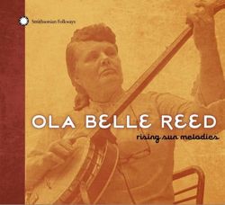
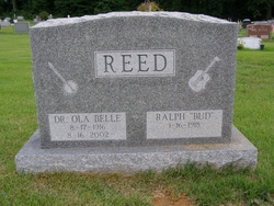

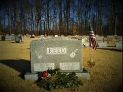
Dr Ola Belle Campbell Reed
| Birth | : | 17 Aug 1916 Grassy Creek Township, Ashe County, North Carolina, USA |
| Death | : | 16 Aug 2002 Cecil County, Maryland, USA |
| Burial | : | St. John the Devine Churchyard, Southrey, West Lindsey District, England |
| Coordinate | : | 53.1843135, -0.2972542 |
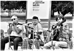
| Description | : | Ola was a folk singer, songwriter and banjo player. During the Great Depression, Arthur Campbell, her father, experienced the failure of his business interests because his customers were unable to pay their bills. One of his cousins found a farm they could rent in Chester County, Pennsylvania, so the family moved in 1934. Ola Belle had already learned to play banjo in the claw hammer style and soon she and brother Alex were playing for parties. In 1936 she met Arthur "Shorty" Wood who hired her as a singer in his band, the North Carolina Ridge Runners,... Read More |
frequently asked questions (FAQ):
-
Where is Dr Ola Belle Campbell Reed's memorial?
Dr Ola Belle Campbell Reed's memorial is located at: St. John the Devine Churchyard, Southrey, West Lindsey District, England.
-
When did Dr Ola Belle Campbell Reed death?
Dr Ola Belle Campbell Reed death on 16 Aug 2002 in Cecil County, Maryland, USA
-
Where are the coordinates of the Dr Ola Belle Campbell Reed's memorial?
Latitude: 53.1843135
Longitude: -0.2972542
Family Members:
Parent
Spouse
Siblings
Children
Flowers:


Nearby Cemetories:
1. St. John the Devine Churchyard
Southrey, West Lindsey District, England
Coordinate: 53.1843135, -0.2972542
2. Bardney Cemetery
Bardney, West Lindsey District, England
Coordinate: 53.2078350, -0.3208830
3. St. Lawrence Churchyard
Bardney, West Lindsey District, England
Coordinate: 53.2095580, -0.3254380
4. St. Margaret's Churchyard
Bucknall, East Lindsey District, England
Coordinate: 53.2039920, -0.2513250
5. Bardney Abbey
Bardney, West Lindsey District, England
Coordinate: 53.2204000, -0.3336000
6. All Saints Churchyard
Horsington, East Lindsey District, England
Coordinate: 53.2023100, -0.2160600
7. All Saints Churchyard
Gautby, East Lindsey District, England
Coordinate: 53.2359800, -0.2413800
8. St Andrew's Churchyard
Bardney, West Lindsey District, England
Coordinate: 53.2442000, -0.3351800
9. St. Leonard's Without Churchyard
Kirkstead, East Lindsey District, England
Coordinate: 53.1361800, -0.2224600
10. All Saints Churchyard
Nocton, North Kesteven District, England
Coordinate: 53.1637001, -0.4151000
11. St. Andrew Churchyard
Potterhanworth, North Kesteven District, England
Coordinate: 53.1814000, -0.4229000
12. St Peters Churchyard
Dunston, North Kesteven District, England
Coordinate: 53.1529600, -0.4120730
13. St. Andrew's Churchyard
Timberland, North Kesteven District, England
Coordinate: 53.1095985, -0.3267715
14. St. Andrew's Churchyard
Timberland, North Kesteven District, England
Coordinate: 53.1095985, -0.3267715
15. St Wilfrid Churchyard
Metheringham, North Kesteven District, England
Coordinate: 53.1380350, -0.4016960
16. St. Andrew's Churchyard
Apley, West Lindsey District, England
Coordinate: 53.2613400, -0.3390200
17. St. Oswald's Churchyard
Blankney, North Kesteven District, England
Coordinate: 53.1264910, -0.4051300
18. St Oswald Churchyard
Walcott, North Kesteven District, England
Coordinate: 53.0945800, -0.3125240
19. St. Oswald Churchyard
Walcott, North Kesteven District, England
Coordinate: 53.0944560, -0.3128500
20. St Margarets Churchyard
Langton, East Lindsey District, England
Coordinate: 53.2034275, -0.1490403
21. Holy Cross Churchyard
Kirkby Green, North Kesteven District, England
Coordinate: 53.1062300, -0.3808000
22. St. Giles' Churchyard
Langton by Wragby, East Lindsey District, England
Coordinate: 53.2764400, -0.2777700
23. St. Edward's Churchyard
Barlings, West Lindsey District, England
Coordinate: 53.2600000, -0.3890000
24. St. Clement's Churchyard
Fiskerton, West Lindsey District, England
Coordinate: 53.2345500, -0.4315200