
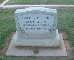

Dulcie Louise Manes Reid
| Birth | : | 4 Mar 1912 Arkansas, USA |
| Death | : | 20 Feb 1992 Sacramento County, California, USA |
| Burial | : | Saint Annes Catholic Cemetery, Shubert, Richardson County, USA |
| Coordinate | : | 40.2042500, -95.6549500 |
| Plot | : | 3-244 |
| Inscription | : | BELOVED MOTHER |
| Description | : | MMN: Love |
frequently asked questions (FAQ):
-
Where is Dulcie Louise Manes Reid's memorial?
Dulcie Louise Manes Reid's memorial is located at: Saint Annes Catholic Cemetery, Shubert, Richardson County, USA.
-
When did Dulcie Louise Manes Reid death?
Dulcie Louise Manes Reid death on 20 Feb 1992 in Sacramento County, California, USA
-
Where are the coordinates of the Dulcie Louise Manes Reid's memorial?
Latitude: 40.2042500
Longitude: -95.6549500
Family Members:
Parent
Siblings
Flowers:


Nearby Cemetories:
1. Saint Annes Catholic Cemetery
Shubert, Richardson County, USA
Coordinate: 40.2042500, -95.6549500
2. Huff Cemetery
Barada, Richardson County, USA
Coordinate: 40.2039000, -95.6248500
3. Berg Cemetery
Barada, Richardson County, USA
Coordinate: 40.2257996, -95.6168976
4. Brick Church Cemetery
Barada, Richardson County, USA
Coordinate: 40.2328000, -95.6155000
5. Cupola Cemetery
Verdon, Richardson County, USA
Coordinate: 40.1892014, -95.7086029
6. Prairie Union Cemetery
Shubert, Richardson County, USA
Coordinate: 40.2475800, -95.7150200
7. Harris Cemetery
Barada, Richardson County, USA
Coordinate: 40.2182999, -95.5730972
8. Verdon Cemetery
Verdon, Richardson County, USA
Coordinate: 40.1450005, -95.6893997
9. Penniwell Cemetery
Shubert, Richardson County, USA
Coordinate: 40.2619000, -95.6994500
10. Saint Pauls Evangelical Lutheran Cemetery
Falls City, Richardson County, USA
Coordinate: 40.1443800, -95.6150400
11. Saint Johns Catholic Cemetery
Barada, Richardson County, USA
Coordinate: 40.2189000, -95.5683000
12. Maple Grove Cemetery
Verdon, Richardson County, USA
Coordinate: 40.1307983, -95.6410980
13. Liberty-Cornell Cemetery
Verdon, Richardson County, USA
Coordinate: 40.1603000, -95.7375000
14. Saint Deroin Cemetery
Barada, Richardson County, USA
Coordinate: 40.2543983, -95.5682983
15. Saint Peters Evangelical Lutheran Church Cemetery
Richardson County, USA
Coordinate: 40.1752014, -95.5491257
16. Stella Cemetery
Stella, Richardson County, USA
Coordinate: 40.2268982, -95.7671967
17. Saint Marks Lutheran Cemetery
Verdon, Richardson County, USA
Coordinate: 40.1160100, -95.6864900
18. Hillsdale Cemetery
Nemaha County, USA
Coordinate: 40.2882996, -95.6010971
19. Half-Breed Cemetery
Nemaha County, USA
Coordinate: 40.2664900, -95.5604900
20. Liberty Township Cemetery
Verdon, Richardson County, USA
Coordinate: 40.1597200, -95.7664100
21. Silver Creek Cemetery
Richardson County, USA
Coordinate: 40.1157990, -95.5969009
22. Fricke Cemetery
Richardson County, USA
Coordinate: 40.1516991, -95.5391998
23. Saint Johns Cemetery
Richardson County, USA
Coordinate: 40.1375008, -95.5188980
24. Archer Cemetery
Falls City, Richardson County, USA
Coordinate: 40.0950200, -95.5736900