
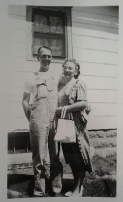
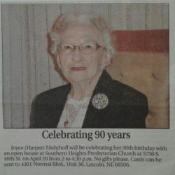
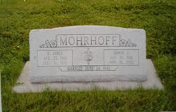

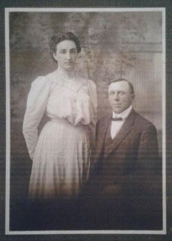
E. Joyce Harper Mohrhoff
| Birth | : | 23 Apr 1918 Adams, Gage County, Nebraska, USA |
| Death | : | 26 Jul 2012 Lincoln, Lancaster County, Nebraska, USA |
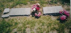
| Burial | : | Highland Cemetery, Adams, Gage County, USA |
| Coordinate | : | 40.4580994, -96.5196991 |
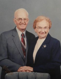
| Description | : | E. Joyce Mohrhoff, 94, of Lincoln, passed away at home on Thursday, July 26, 2012. Born April 23, 1918 near Adams, Nebraska to John F. and Clara (Silver) Harper. Graduated 1935 from Adams High School, married her classmate Edwin (Eddie) Mohrhoff on June 24, 1942, and lived in Lincoln and surrounding areas. Active member, office holder and choir member of Union Church, College View Presbyterian, and presently Southern Heights Presbyterian Church. Homemaker, gardener, and office manager of husband’s endeavors. Enjoyed traveling, music, reading, and active participation with family and friends. Survived by nephews: Wayne “Sam” and Bessie Oltman,... Read More |
frequently asked questions (FAQ):
-
Where is E. Joyce Harper Mohrhoff's memorial?
E. Joyce Harper Mohrhoff's memorial is located at: Highland Cemetery, Adams, Gage County, USA.
-
When did E. Joyce Harper Mohrhoff death?
E. Joyce Harper Mohrhoff death on 26 Jul 2012 in Lincoln, Lancaster County, Nebraska, USA
-
Where are the coordinates of the E. Joyce Harper Mohrhoff's memorial?
Latitude: 40.4580994
Longitude: -96.5196991
Family Members:
Parent
Spouse
Siblings
Flowers:


Nearby Cemetories:
1. Highland Cemetery
Adams, Gage County, USA
Coordinate: 40.4580994, -96.5196991
2. Hooker Cemetery
Adams, Gage County, USA
Coordinate: 40.4207993, -96.4732971
3. Grandview Cemetery
Gage County, USA
Coordinate: 40.4617004, -96.6091995
4. Granite Hill Cemetery
Johnson County, USA
Coordinate: 40.4180984, -96.4417038
5. Immanuel Cemetery
Sterling, Johnson County, USA
Coordinate: 40.4692001, -96.4253006
6. Latrobe Cemetery
Sterling, Johnson County, USA
Coordinate: 40.5151000, -96.4557000
7. Weber Cemetery
Sterling, Johnson County, USA
Coordinate: 40.4581000, -96.4177000
8. Saint Johns Lutheran Cemetery
Cortland, Gage County, USA
Coordinate: 40.5078300, -96.6252700
9. Firth Cemetery
Firth, Lancaster County, USA
Coordinate: 40.5250015, -96.6085968
10. Pella Cemetery
Panama, Lancaster County, USA
Coordinate: 40.5555992, -96.5014038
11. Saint John North Lutheran Cemetery
Sterling, Johnson County, USA
Coordinate: 40.4689500, -96.3878500
12. Sunnyside Cemetery
Cortland, Gage County, USA
Coordinate: 40.4799200, -96.6511800
13. South Saint John Lutheran Cemetery
Sterling, Johnson County, USA
Coordinate: 40.4355500, -96.3858000
14. Dietz Cemetery
Firth, Lancaster County, USA
Coordinate: 40.5449982, -96.6286011
15. Sterling Cemetery
Sterling, Johnson County, USA
Coordinate: 40.4585991, -96.3582993
16. Panama Cemetery
Panama, Lancaster County, USA
Coordinate: 40.5821991, -96.5255966
17. Zion Evangelical Lutheran Cemetery
Pickrell, Gage County, USA
Coordinate: 40.3456001, -96.6147003
18. Christ Lutheran Church Cemetery
Pickrell, Gage County, USA
Coordinate: 40.4079410, -96.6848370
19. Saint James Cemetery
Cortland, Gage County, USA
Coordinate: 40.4886050, -96.7036050
20. Cortland Cemetery
Cortland, Gage County, USA
Coordinate: 40.4879200, -96.7041250
21. Crab Orchard Cemetery
Crab Orchard, Johnson County, USA
Coordinate: 40.3274994, -96.4366989
22. Solon Cemetery
Otoe County, USA
Coordinate: 40.5917015, -96.4436035
23. Holland Cemetery
Holland, Lancaster County, USA
Coordinate: 40.5957985, -96.5997009
24. Rosehill Cemetery
Douglas, Otoe County, USA
Coordinate: 40.5845940, -96.3867900