

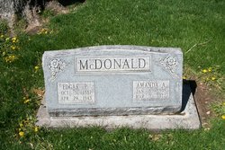
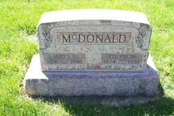
Edgar P “Ed” McDonald
| Birth | : | 31 Oct 1887 |
| Death | : | 29 Apr 1943 |
| Burial | : | St. John the Baptist Churchyard, Hinton Charterhouse, Bath and North East Somerset Unitary Authority, England |
| Coordinate | : | 51.3233330, -2.3219440 |
frequently asked questions (FAQ):
-
Where is Edgar P “Ed” McDonald's memorial?
Edgar P “Ed” McDonald's memorial is located at: St. John the Baptist Churchyard, Hinton Charterhouse, Bath and North East Somerset Unitary Authority, England.
-
When did Edgar P “Ed” McDonald death?
Edgar P “Ed” McDonald death on 29 Apr 1943 in
-
Where are the coordinates of the Edgar P “Ed” McDonald's memorial?
Latitude: 51.3233330
Longitude: -2.3219440
Family Members:
Parent

Spouse
Siblings


Children
Flowers:


Nearby Cemetories:
1. St. John the Baptist Churchyard
Hinton Charterhouse, Bath and North East Somerset Unitary Authority, England
Coordinate: 51.3233330, -2.3219440
2. Freshford Cemetery
Freshford, Bath and North East Somerset Unitary Authority, England
Coordinate: 51.3379620, -2.3082970
3. Midford Burial Ground
Bath, Bath and North East Somerset Unitary Authority, England
Coordinate: 51.3394360, -2.3391424
4. Saint Peters Churchyard
Freshford, Bath and North East Somerset Unitary Authority, England
Coordinate: 51.3400570, -2.3033340
5. St Leonard Churchyard
Farleigh Hungerford, Mendip District, England
Coordinate: 51.3155390, -2.2884820
6. Farleigh Hungerford Castle
Farleigh Hungerford, Mendip District, England
Coordinate: 51.3173500, -2.2869590
7. Norton St. Philip Churchyard
Norton St Philip, Mendip District, England
Coordinate: 51.3001680, -2.3279700
8. St Julian's Churchyard
Wellow, Bath and North East Somerset Unitary Authority, England
Coordinate: 51.3240160, -2.3717630
9. All Saints Churchyard
Tellisford, Mendip District, England
Coordinate: 51.2997270, -2.2877180
10. St. Michael's Churchyard
Monkton Combe, Bath and North East Somerset Unitary Authority, England
Coordinate: 51.3559540, -2.3285700
11. St. James' Churchyard
South Stoke, Bath and North East Somerset Unitary Authority, England
Coordinate: 51.3497220, -2.3652780
12. Union Chapel
Combe Down, Bath and North East Somerset Unitary Authority, England
Coordinate: 51.3594751, -2.3443662
13. Combe Hay Parish Churchyard
Combe Hay, Bath and North East Somerset Unitary Authority, England
Coordinate: 51.3371120, -2.3817390
14. St. Lawrence Churchyard
Woolverton, Mendip District, England
Coordinate: 51.2851540, -2.3021790
15. Combe Hay Cemetery
Combe Hay, Bath and North East Somerset Unitary Authority, England
Coordinate: 51.3397819, -2.3814323
16. Jewish Burial Ground
Combe Down, Bath and North East Somerset Unitary Authority, England
Coordinate: 51.3599170, -2.3534670
17. Prior Park College
Bath, Bath and North East Somerset Unitary Authority, England
Coordinate: 51.3645990, -2.3442400
18. Wellow & Shoscombe Cemetery
Wellow, Bath and North East Somerset Unitary Authority, England
Coordinate: 51.3165527, -2.3916632
19. Christ Church Churchyard
Rode, Mendip District, England
Coordinate: 51.2861620, -2.2790890
20. Bath Union Workhouse Graveyard
Bath, Bath and North East Somerset Unitary Authority, England
Coordinate: 51.3584160, -2.3711140
21. St Mary's Churchyard
Laverton, Mendip District, England
Coordinate: 51.2757380, -2.3195910
22. Bath Union Workhouse Burial Ground
Bath, Bath and North East Somerset Unitary Authority, England
Coordinate: 51.3570889, -2.3773370
23. Holy Trinity Churchyard
Bradford-on-Avon, Wiltshire Unitary Authority, England
Coordinate: 51.3465927, -2.2538147
24. St John the Evangelist Cemetery
Bath, Bath and North East Somerset Unitary Authority, England
Coordinate: 51.3696700, -2.3487400