
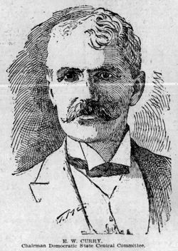
Edgar W. Curry
| Birth | : | 25 Jul 1848 Elkhart, Elkhart County, Indiana, USA |
| Death | : | 18 Nov 1896 Iowa, USA |
| Burial | : | Sacramento City Cemetery, Sacramento, Sacramento County, USA |
| Coordinate | : | 38.5636864, -121.5009537 |
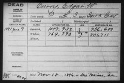
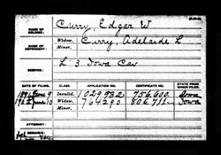
| Plot | : | Row 16; Co. L. 3rd Ia. Cav. Civil War |
| Description | : | Elks’ Ordeal Causes the Death of Democratic Chairman Curry. Des Moines, Nov. 18 – Special: E. W. Curry, chairman of the democratic state central committee, died early this morning at the Savery hotel in this city, where he has been sick for two months. Mr. Curry’s death is reported to have been the result of injuries received while being initiated into a Des Moines lodge of elks. Blood poisoning resulted from the injuries and this caused death. As part of the ceremony he was seated in a chair with a thin iron seat, a large lighted lamp placed under... Read More |
frequently asked questions (FAQ):
-
Where is Edgar W. Curry's memorial?
Edgar W. Curry's memorial is located at: Sacramento City Cemetery, Sacramento, Sacramento County, USA.
-
When did Edgar W. Curry death?
Edgar W. Curry death on 18 Nov 1896 in Iowa, USA
-
Where are the coordinates of the Edgar W. Curry's memorial?
Latitude: 38.5636864
Longitude: -121.5009537
Family Members:
Parent

Spouse
Siblings
Children


Nearby Cemetories:
1. Sacramento City Cemetery
Sacramento, Sacramento County, USA
Coordinate: 38.5636864, -121.5009537
2. Buddhist Church of Sacramento Nokotsudo
Sacramento, Sacramento County, USA
Coordinate: 38.5639300, -121.4978400
3. Sunset Hill Cemetery
Sacramento, Sacramento County, USA
Coordinate: 38.5608000, -121.5037300
4. Masonic Lawn Cemetery
Sacramento, Sacramento County, USA
Coordinate: 38.5604720, -121.5032600
5. Odd Fellows Lawn Cemetery and Mausoleum
Sacramento, Sacramento County, USA
Coordinate: 38.5585000, -121.5011000
6. National Shrine of Our Lady of Guadalupe Crypt
Sacramento, Sacramento County, USA
Coordinate: 38.5704800, -121.5014400
7. California State Capitol
Sacramento, Sacramento County, USA
Coordinate: 38.5760994, -121.4931488
8. Saint Joseph Cemetery
Sacramento, Sacramento County, USA
Coordinate: 38.5574989, -121.4835968
9. Holy Ascension Russian Orthodox Cemetery
Sacramento, Sacramento County, USA
Coordinate: 38.5846212, -121.4936736
10. Trinity Episcopal Cathedral Columbarium
Sacramento, Sacramento County, USA
Coordinate: 38.5705500, -121.4723770
11. New Helvetia Cemetery (Defunct)
Sacramento, Sacramento County, USA
Coordinate: 38.5731600, -121.4639900
12. Pho Minh Temple Columbarium
Sacramento, Sacramento County, USA
Coordinate: 38.5340100, -121.4769000
13. East Lawn Memorial Park
Sacramento, Sacramento County, USA
Coordinate: 38.5612960, -121.4492760
14. Saint Rose Cemetery (Defunct)
Sacramento, Sacramento County, USA
Coordinate: 38.5208015, -121.4672012
15. Saint Mary's Catholic Cemetery and Mausoleum
Sacramento, Sacramento County, USA
Coordinate: 38.5298900, -121.4261200
16. Sacramento Memorial Lawn Cemetery
Sacramento, Sacramento County, USA
Coordinate: 38.5146484, -121.4380341
17. Sacramento County Hospital Cemetery
Sacramento, Sacramento County, USA
Coordinate: 38.5289300, -121.4239100
18. Home of Peace Cemetery
Sacramento, Sacramento County, USA
Coordinate: 38.5137558, -121.4382782
19. Russian Orthodox Cemetery
Sacramento, Sacramento County, USA
Coordinate: 38.5268800, -121.4244300
20. Sacramento County Cemetery
Sacramento County, USA
Coordinate: 38.5267900, -121.4233700
21. Sacramento County Veterans Memorial Cemetery
Sacramento, Sacramento County, USA
Coordinate: 38.5252838, -121.4239120
22. Tinh Xa Ngoc An Temple Columbarium
Sacramento, Sacramento County, USA
Coordinate: 38.5190200, -121.4159500
23. Elder Creek Cemetery
Florin, Sacramento County, USA
Coordinate: 38.5111008, -121.4169006
24. Kim Quang Temple Columbarium
Sacramento, Sacramento County, USA
Coordinate: 38.5996600, -121.3904700