
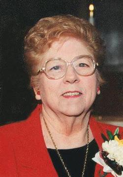

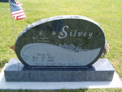
Edith Bell Silvey Sonksen
| Birth | : | 21 Mar 1923 Temple Hill, Barren County, Kentucky, USA |
| Death | : | 23 Aug 2014 Boone, Boone County, Iowa, USA |
| Burial | : | South Marion Cemetery, Stratford, Hamilton County, USA |
| Coordinate | : | 42.2327995, -93.8735962 |
| Description | : | Edith Bell Sonksen, age 91, of Boone and formerly of Stratford, died August 23, 2014, at the Westhaven Community. Edith Bell Sonksen was born in Temple Hill, Kentucky, on March 21, 1923, the daughter of Marshall and Etta (Moore) Silvey. She graduated from Stratford High School in 1941 and on April 27, 1942, Edith married Weldon Sonksen in Princeton, Missouri. The couple lived near Stratford where Weldon farmed. Edith raised chickens, had a vegetable garden and canned her produce, and also enjoyed flower gardening. She also enjoyed quilting, singing, playing guitar, cooking, baking, especially pies and chocolate chip cookies, and she enjoyed yodeling. In... Read More |
frequently asked questions (FAQ):
-
Where is Edith Bell Silvey Sonksen's memorial?
Edith Bell Silvey Sonksen's memorial is located at: South Marion Cemetery, Stratford, Hamilton County, USA.
-
When did Edith Bell Silvey Sonksen death?
Edith Bell Silvey Sonksen death on 23 Aug 2014 in Boone, Boone County, Iowa, USA
-
Where are the coordinates of the Edith Bell Silvey Sonksen's memorial?
Latitude: 42.2327995
Longitude: -93.8735962
Family Members:
Parent


Spouse
Siblings
Children
Flowers:


Nearby Cemetories:
1. South Marion Cemetery
Stratford, Hamilton County, USA
Coordinate: 42.2327995, -93.8735962
2. Oakwood Cemetery
Stratford, Hamilton County, USA
Coordinate: 42.2942009, -93.9182968
3. Mineral Ridge Cemetery
Ridgeport, Boone County, USA
Coordinate: 42.1749992, -93.9266968
4. Hooks Point Cemetery
Hamilton County, USA
Coordinate: 42.2944530, -93.9199090
5. Hardin Township Cemetery
Hardin Township, Webster County, USA
Coordinate: 42.2411003, -93.9708023
6. Saint Paul Lutheran Cemetery
Boone, Boone County, USA
Coordinate: 42.1700000, -93.8070000
7. Boone County Poor Farm Cemetery
Boone County, USA
Coordinate: 42.1591100, -93.9159000
8. White Cemetery
Boone County, USA
Coordinate: 42.1777992, -93.9636002
9. Lake Center Cemetery
Stanhope, Hamilton County, USA
Coordinate: 42.2482986, -93.7568970
10. Leininger Cemetery
Boone County, USA
Coordinate: 42.1492004, -93.8356018
11. Lawn Hill Cemetery
Stanhope, Hamilton County, USA
Coordinate: 42.2677994, -93.7611008
12. Nesse Cemetery
Hamilton County, USA
Coordinate: 42.3250008, -93.8933029
13. Neese Cemetery
Homer, Hamilton County, USA
Coordinate: 42.3250000, -93.8935000
14. Linn Cemetery
Pilot Mound, Boone County, USA
Coordinate: 42.2045330, -93.9970230
15. Vegors Cemetery
Webster County, USA
Coordinate: 42.3177986, -93.9421997
16. Mackey Cemetery
Boone County, USA
Coordinate: 42.1675000, -93.7565000
17. Runyan Cemetery
Pilot Mound, Boone County, USA
Coordinate: 42.1749992, -94.0015030
18. Saint Pauls Church Cemetery
Jewell, Hamilton County, USA
Coordinate: 42.2490100, -93.7173400
19. Schlicht Cemetery
Fraser, Boone County, USA
Coordinate: 42.1444200, -93.9780100
20. Bass Cemetery
Dayton, Webster County, USA
Coordinate: 42.2966995, -94.0149994
21. Saratoga Cemetery
Stanhope, Hamilton County, USA
Coordinate: 42.3539009, -93.8167038
22. Pilot Mound Cemetery
Pilot Mound, Boone County, USA
Coordinate: 42.1636200, -94.0282600
23. Ellsworth Clear Lake Cemetery
Randall, Hamilton County, USA
Coordinate: 42.2268930, -93.6926200
24. Bass Point Cemetery
Boone, Boone County, USA
Coordinate: 42.0992012, -93.8957977