
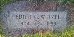
| Birth | : | 18 Aug 1904 Almira, Lincoln County, Washington, USA |
| Death | : | 4 Sep 1959 Moses Lake, Grant County, Washington, USA |
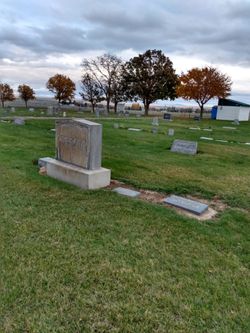
| Burial | : | Calvary Cemetery, Sandusky, Erie County, USA |
| Coordinate | : | 41.4383011, -82.7339020 |
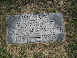
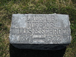
| Description | : | AGED 55 YEARS, 17 DAYS. Edith Gertrude Schrock the daughter of Willis Elmore Schrock and Laura Belle Brackney, married Clarence Everett Wetzel the son of Lewis Wetzel and Ava Odessa Hancock. They were married on September 5th, 1926 in Almira, Lincoln County, Washington. They had 1 Child- CLARENCE LEROY WETZEL. / Edith died at Moses Lake, WA. |
frequently asked questions (FAQ):
-
Where is Edith Gertrude Schrock Wetzel's memorial?
Edith Gertrude Schrock Wetzel's memorial is located at: Calvary Cemetery, Sandusky, Erie County, USA.
-
When did Edith Gertrude Schrock Wetzel death?
Edith Gertrude Schrock Wetzel death on 4 Sep 1959 in Moses Lake, Grant County, Washington, USA
-
Where are the coordinates of the Edith Gertrude Schrock Wetzel's memorial?
Latitude: 41.4383011
Longitude: -82.7339020
Family Members:
Parent
Spouse

Siblings
Flowers:


Nearby Cemetories:
1. Calvary Cemetery
Sandusky, Erie County, USA
Coordinate: 41.4383011, -82.7339020
2. Saint Marys Cemetery
Sandusky, Erie County, USA
Coordinate: 41.4425011, -82.7285995
3. Saint Joseph's Cemetery
Sandusky, Erie County, USA
Coordinate: 41.4420800, -82.7259500
4. Cholera Cemetery
Sandusky, Erie County, USA
Coordinate: 41.4496660, -82.7252970
5. First Cemetery (Defunct)
Sandusky, Erie County, USA
Coordinate: 41.4543770, -82.7216040
6. Grace Episcopal Church Columbarium
Sandusky, Erie County, USA
Coordinate: 41.4547630, -82.7093940
7. Saint Stephen United Church of Christ Columbarium
Sandusky, Erie County, USA
Coordinate: 41.4331790, -82.6861310
8. Oakland Cemetery
Sandusky, Erie County, USA
Coordinate: 41.4267807, -82.6873398
9. Venice Cemetery
Margaretta Township, Erie County, USA
Coordinate: 41.4413690, -82.7829920
10. Oheb Shalom Cemetery
Perkins Township, Erie County, USA
Coordinate: 41.4199800, -82.6902400
11. Erie County Cemetery
Sandusky, Erie County, USA
Coordinate: 41.4200580, -82.6896760
12. Ohio Veterans Home Cemetery
Sandusky, Erie County, USA
Coordinate: 41.4182940, -82.6881920
13. Wilmer Cemetery
Wilmer, Erie County, USA
Coordinate: 41.4008848, -82.7074048
14. Baum Family Cemetery
Perkins Township, Erie County, USA
Coordinate: 41.3837600, -82.7055420
15. Johnson's Island Confederate Cemetery
Marblehead, Ottawa County, USA
Coordinate: 41.5003014, -82.7300034
16. Castalia Cemetery
Castalia, Erie County, USA
Coordinate: 41.3957410, -82.8015733
17. Old Perkins Cemetery
Perkins Township, Erie County, USA
Coordinate: 41.3851460, -82.6683020
18. Perkins Cemetery
Sandusky, Erie County, USA
Coordinate: 41.3997002, -82.6505966
19. Beatty Cemetery (Defunct)
Perkins Township, Erie County, USA
Coordinate: 41.3961370, -82.6508980
20. Osborn Park Cemetery
Sandusky, Erie County, USA
Coordinate: 41.4184280, -82.6361480
21. War of 1812 Battle Site
Mineyahta-on-the Bay, Ottawa County, USA
Coordinate: 41.5140350, -82.7438530
22. Hartshorn Cemetery
Danbury, Ottawa County, USA
Coordinate: 41.5144440, -82.7499530
23. Sandhill Cemetery
Castalia, Erie County, USA
Coordinate: 41.3616982, -82.7589035
24. Wolcott Cemetery
Marblehead, Ottawa County, USA
Coordinate: 41.5177994, -82.7403030