
| Memorials | : | 1 |
| Location | : | Mineyahta-on-the Bay, Ottawa County, USA |
| Coordinate | : | 41.5140350, -82.7438530 |
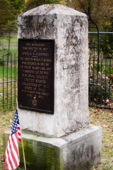
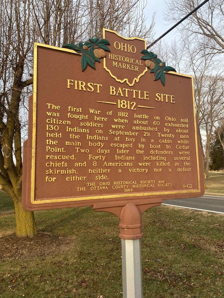
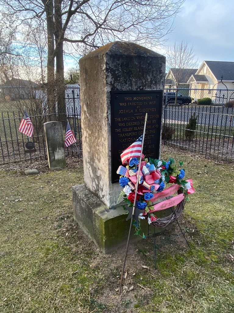
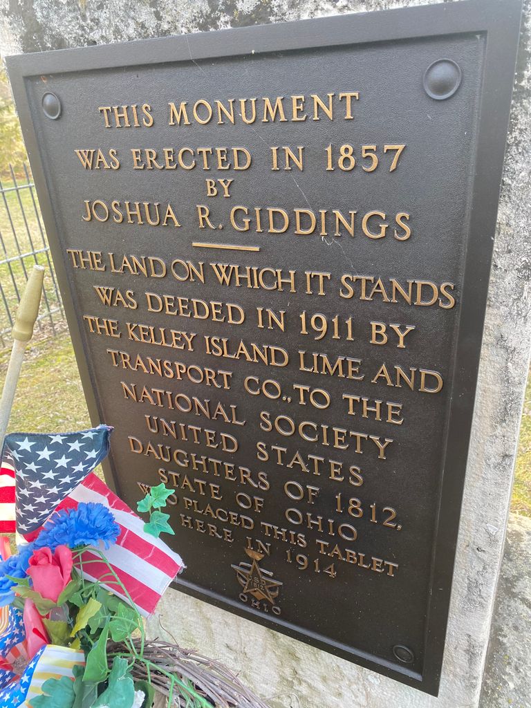
| Description | : | This is a memorial monument (within "Battlefield Park") dedicated to the memory of the men who died in the 1812 "Skirmish on the Peninsula". -- [The scattered bones of the dead, were later gathered together and interred near this site, by Horace Ramsdell, whose young brother had died in this "skirmish".] This monument is near the location of the pioneer cabin of a Canadian trader named "Mr. Patterson", where some of the survivors of the 'skirmish' had found safety. [Later historians erroneously attributed this to be the cabin of Benajah Wolcott, but which instead was considerably east of this location (... Read More |
frequently asked questions (FAQ):
-
Where is War of 1812 Battle Site?
War of 1812 Battle Site is located at E Bay Shore Road (Danbury Twp.) Mineyahta-on-the Bay, Ottawa County ,Ohio , 43440USA.
-
War of 1812 Battle Site cemetery's updated grave count on graveviews.com?
1 memorials
-
Where are the coordinates of the War of 1812 Battle Site?
Latitude: 41.5140350
Longitude: -82.7438530
Nearby Cemetories:
1. Hartshorn Cemetery
Danbury, Ottawa County, USA
Coordinate: 41.5144440, -82.7499530
2. Wolcott Cemetery
Marblehead, Ottawa County, USA
Coordinate: 41.5177994, -82.7403030
3. Johnson's Island Confederate Cemetery
Marblehead, Ottawa County, USA
Coordinate: 41.5003014, -82.7300034
4. Russian Cemetery
Marblehead, Ottawa County, USA
Coordinate: 41.5335999, -82.7371979
5. Saint Joseph's Catholic Cemetery
Marblehead, Ottawa County, USA
Coordinate: 41.5344009, -82.7382965
6. Holy Assumption Orthodox Cemetery
Marblehead, Ottawa County, USA
Coordinate: 41.5361530, -82.7389380
7. Kelly Cemetery
Danbury, Ottawa County, USA
Coordinate: 41.5245720, -82.7705950
8. Chautauqua Park Memorial Garden
Lakeside, Ottawa County, USA
Coordinate: 41.5412410, -82.7418240
9. Saint Mary's Byzantine Catholic Cemetery
Marblehead, Ottawa County, USA
Coordinate: 41.5409012, -82.7223969
10. Clemons Cemetery
Marblehead, Ottawa County, USA
Coordinate: 41.5409012, -82.7213974
11. Sackett Cemetery
Danbury, Ottawa County, USA
Coordinate: 41.5303001, -82.7872009
12. Saint Pauls Lutheran Church Cemetery
Lakeside, Ottawa County, USA
Coordinate: 41.5242200, -82.8049100
13. Jamison Cemetery
Danbury, Ottawa County, USA
Coordinate: 41.5050060, -82.8180740
14. Lockwood Cemetery
Lakeside, Ottawa County, USA
Coordinate: 41.5435140, -82.8161560
15. First Cemetery (Defunct)
Sandusky, Erie County, USA
Coordinate: 41.4543770, -82.7216040
16. Grace Episcopal Church Columbarium
Sandusky, Erie County, USA
Coordinate: 41.4547630, -82.7093940
17. Cholera Cemetery
Sandusky, Erie County, USA
Coordinate: 41.4496660, -82.7252970
18. Saint Marys Cemetery
Sandusky, Erie County, USA
Coordinate: 41.4425011, -82.7285995
19. Saint Joseph's Cemetery
Sandusky, Erie County, USA
Coordinate: 41.4420800, -82.7259500
20. Calvary Cemetery
Sandusky, Erie County, USA
Coordinate: 41.4383011, -82.7339020
21. Venice Cemetery
Margaretta Township, Erie County, USA
Coordinate: 41.4413690, -82.7829920
22. Catawba Island Cemetery
Catawba Island, Ottawa County, USA
Coordinate: 41.5569000, -82.8403015
23. Dwelle Cemetery
Port Clinton, Ottawa County, USA
Coordinate: 41.5069008, -82.8563995
24. K'Burg Family Cemetery
Catawba Island Township, Ottawa County, USA
Coordinate: 41.5589400, -82.8463000