
| Birth | : | 3 Sep 1884 Marysville, Marshall County, Kansas, USA |
| Death | : | 12 Jan 1972 Topeka, Shawnee County, Kansas, USA |
| Burial | : | Portales Cemetery, Portales, Roosevelt County, USA |
| Coordinate | : | 34.1860500, -103.3199200 |
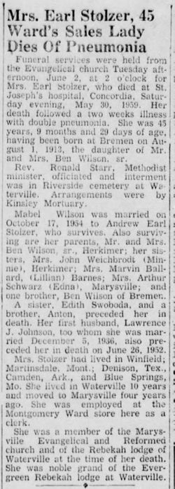
| Description | : | Topeka State Journal Wednesday 12 Jan., 1972, pg. 21: Mrs. Edith Marie Wilson, 87, Topeka, died this morning in a local hospital following a short illness. She was born Sept. 3, 1884 at Marysville. She had been a resident of Topeka since June 1966. She had lived all her life previously in the Marysville-Herkimer communities. She was a member of the Happy Hour Club of Herkimer and Seabrook United Church of Christ. She was married to Ben R. Wilson at Marysville on April 15, 1902. He died Nov. 7, 1959. Survivors include a son, 3 daughters, 8 grandchildren, 12 great-grandchildren, and 1 great-great-grandchild. |
frequently asked questions (FAQ):
-
Where is Edith Marie Moeske Wilson's memorial?
Edith Marie Moeske Wilson's memorial is located at: Portales Cemetery, Portales, Roosevelt County, USA.
-
When did Edith Marie Moeske Wilson death?
Edith Marie Moeske Wilson death on 12 Jan 1972 in Topeka, Shawnee County, Kansas, USA
-
Where are the coordinates of the Edith Marie Moeske Wilson's memorial?
Latitude: 34.1860500
Longitude: -103.3199200
Family Members:
Parent

Spouse
Siblings
Children
Flowers:


Nearby Cemetories:
1. Portales Cemetery
Portales, Roosevelt County, USA
Coordinate: 34.1860500, -103.3199200
2. Rest Lawn Memorial Cemetery
Portales, Roosevelt County, USA
Coordinate: 34.1342010, -103.3347015
3. Eiland Cemetery
Roosevelt County, USA
Coordinate: 34.1169014, -103.1949997
4. Bethel Cemetery
Roosevelt County, USA
Coordinate: 34.2146988, -103.4961014
5. Arch Cemetery
Roosevelt County, USA
Coordinate: 34.1133003, -103.1418991
6. Mount Zion Cemetery
Dora, Roosevelt County, USA
Coordinate: 33.9824982, -103.3268967
7. Floyd Cemetery
Floyd, Roosevelt County, USA
Coordinate: 34.2141991, -103.5800018
8. Black Tower Cemetery
Curry County, USA
Coordinate: 34.4087510, -103.3365440
9. Mission Garden of Memories Cemetery
Clovis, Curry County, USA
Coordinate: 34.4049263, -103.2436752
10. Inez Cemetery
Inez, Roosevelt County, USA
Coordinate: 33.9667015, -103.1433029
11. Lawn Haven Memorial Gardens Cemetery
Clovis, Curry County, USA
Coordinate: 34.4333000, -103.1856003
12. Texico Cemetery
Texico, Curry County, USA
Coordinate: 34.3758011, -103.0849991
13. Upton Cemetery
Upton, Roosevelt County, USA
Coordinate: 34.1553001, -103.6524963
14. Longs Cemetery
Portales, Roosevelt County, USA
Coordinate: 33.9239006, -103.2110977
15. West Camp Cemetery
Bailey County, USA
Coordinate: 34.2811012, -102.9757996
16. Reid Cemetery
Ranchvale, Curry County, USA
Coordinate: 34.4937440, -103.3188840
17. Roebuck Cemetery
Roosevelt County, USA
Coordinate: 33.9091440, -103.0740910
18. Memorial Cemetery
Melrose, Curry County, USA
Coordinate: 34.4307251, -103.6171112
19. Elida Cemetery
Elida, Roosevelt County, USA
Coordinate: 33.9645996, -103.6491013
20. Bobo Qualls Cemetery
Ranchvale, Curry County, USA
Coordinate: 34.5211670, -103.4501290
21. Richland Cemetery
Roosevelt County, USA
Coordinate: 33.8288994, -103.2835999
22. Causey Cemetery
Causey, Roosevelt County, USA
Coordinate: 33.8507996, -103.1418991
23. North Cemetery
Melrose, Curry County, USA
Coordinate: 34.4496994, -103.6410980
24. Ingram Cemetery
Roosevelt County, USA
Coordinate: 34.1114006, -103.7632980