
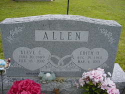


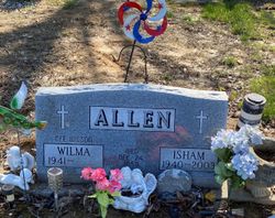
Edith O. Burch Allen
| Birth | : | 29 Aug 1914 Jackson County, Kentucky, USA |
| Death | : | 4 Mar 2003 Metamora, Franklin County, Indiana, USA |
| Burial | : | Church of St John of Jerusalem, Herefordshire Unitary Authority, England |
| Coordinate | : | 51.9914740, -2.6542940 |
| Description | : | w/o Bleve C Allen, d/o Riley & Daisy Marcum Burch |
frequently asked questions (FAQ):
-
Where is Edith O. Burch Allen's memorial?
Edith O. Burch Allen's memorial is located at: Church of St John of Jerusalem, Herefordshire Unitary Authority, England.
-
When did Edith O. Burch Allen death?
Edith O. Burch Allen death on 4 Mar 2003 in Metamora, Franklin County, Indiana, USA
-
Where are the coordinates of the Edith O. Burch Allen's memorial?
Latitude: 51.9914740
Longitude: -2.6542940
Family Members:
Parent

Spouse

Siblings


Children

Flowers:


Nearby Cemetories:
1. St. David's Churchyard
Little Dewchurch, Herefordshire Unitary Authority, England
Coordinate: 51.9822934, -2.6865234
2. St Dubricius' Church
Ballingham, Herefordshire Unitary Authority, England
Coordinate: 51.9818590, -2.6186990
3. St Cuthbert Churchyard
Holme Lacy, Herefordshire Unitary Authority, England
Coordinate: 52.0099440, -2.6293610
4. Hoarwithy Church of England
Hentland, Herefordshire Unitary Authority, England
Coordinate: 51.9612740, -2.6625310
5. Priory Churchyard
Aconbury, Herefordshire Unitary Authority, England
Coordinate: 51.9978900, -2.7052160
6. St John The Baptist Churchyard
Kings Caple, Herefordshire Unitary Authority, England
Coordinate: 51.9562740, -2.6433720
7. All Saints Churchyard
Brockhampton, Herefordshire Unitary Authority, England
Coordinate: 51.9863200, -2.5924500
8. Little Birch Churchyard
Little Birch, Herefordshire Unitary Authority, England
Coordinate: 51.9770250, -2.7126530
9. Aconbury Hill
Aconbury, Herefordshire Unitary Authority, England
Coordinate: 51.9932540, -2.7212790
10. St. Andrew's Churchyard
Hampton Bishop, Herefordshire Unitary Authority, England
Coordinate: 52.0387800, -2.6440900
11. St Mary's Churchyard
Foy, Herefordshire Unitary Authority, England
Coordinate: 51.9520402, -2.5866687
12. St Andrew and St Mary Churchyard
How Caple, Herefordshire Unitary Authority, England
Coordinate: 51.9719160, -2.5666430
13. St. Dubricius Churchyard
Hentland, Herefordshire Unitary Authority, England
Coordinate: 51.9342080, -2.6660250
14. St. John the Baptist Churchyard
Llanwarne, Herefordshire Unitary Authority, England
Coordinate: 51.9501676, -2.7203512
15. St Martin Churchyard
Hereford, Herefordshire Unitary Authority, England
Coordinate: 52.0450100, -2.7202700
16. St. Michael and All Angels Churchyard
Brampton Abbots, Herefordshire Unitary Authority, England
Coordinate: 51.9347980, -2.5817590
17. St Peter's Churchyard
Dormington, Herefordshire Unitary Authority, England
Coordinate: 52.0586605, -2.6094343
18. Hereford Cathedral
Hereford, Herefordshire Unitary Authority, England
Coordinate: 52.0541810, -2.7162690
19. Church of the Grey Friars
Hereford, Herefordshire Unitary Authority, England
Coordinate: 52.0528480, -2.7209559
20. St Peter with St Owen Churchyard
Hereford, Herefordshire Unitary Authority, England
Coordinate: 52.0561280, -2.7126470
21. St. Nicholas' Churchyard
Hereford, Herefordshire Unitary Authority, England
Coordinate: 52.0542540, -2.7207160
22. Barton Hall Cemetery
Hereford, Herefordshire Unitary Authority, England
Coordinate: 52.0541484, -2.7227701
23. St Bridget Churchyard
Bridstow, Herefordshire Unitary Authority, England
Coordinate: 51.9204600, -2.6055410
24. Belmont Abbey
Hereford, Herefordshire Unitary Authority, England
Coordinate: 52.0393000, -2.7564000