
| Memorials | : | 6 |
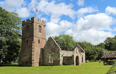
| Location | : | Llanwarne, Herefordshire Unitary Authority, England |
| Coordinate | : | 51.9501676, -2.7203512 |
| Description | : | Medieval church ruin with a few gravestones. |
frequently asked questions (FAQ):
-
Where is St. John the Baptist Churchyard?
St. John the Baptist Churchyard is located at Llanwarne, Herefordshire Unitary Authority ,Herefordshire ,England.
-
St. John the Baptist Churchyard cemetery's updated grave count on graveviews.com?
6 memorials
-
Where are the coordinates of the St. John the Baptist Churchyard?
Latitude: 51.9501676
Longitude: -2.7203512
Nearby Cemetories:
1. Little Birch Churchyard
Little Birch, Herefordshire Unitary Authority, England
Coordinate: 51.9770250, -2.7126530
2. St. Dubricius Churchyard
Hentland, Herefordshire Unitary Authority, England
Coordinate: 51.9342080, -2.6660250
3. Hoarwithy Church of England
Hentland, Herefordshire Unitary Authority, England
Coordinate: 51.9612740, -2.6625310
4. St. David's Churchyard
Little Dewchurch, Herefordshire Unitary Authority, England
Coordinate: 51.9822934, -2.6865234
5. Aconbury Hill
Aconbury, Herefordshire Unitary Authority, England
Coordinate: 51.9932540, -2.7212790
6. St John The Baptist Churchyard
Kings Caple, Herefordshire Unitary Authority, England
Coordinate: 51.9562740, -2.6433720
7. Priory Churchyard
Aconbury, Herefordshire Unitary Authority, England
Coordinate: 51.9978900, -2.7052160
8. St. Mary & David Churchyard
Kilpeck, Herefordshire Unitary Authority, England
Coordinate: 51.9692310, -2.8076150
9. Church of St John of Jerusalem
Herefordshire Unitary Authority, England
Coordinate: 51.9914740, -2.6542940
10. St Michael churchyard
Garway, Herefordshire Unitary Authority, England
Coordinate: 51.8982110, -2.7934460
11. St Dubricius' Church
Ballingham, Herefordshire Unitary Authority, England
Coordinate: 51.9818590, -2.6186990
12. St Bridget Churchyard
Bridstow, Herefordshire Unitary Authority, England
Coordinate: 51.9204600, -2.6055410
13. St Mary's Churchyard
Kentchurch, Herefordshire Unitary Authority, England
Coordinate: 51.9263169, -2.8456161
14. St Cuthbert Churchyard
Holme Lacy, Herefordshire Unitary Authority, England
Coordinate: 52.0099440, -2.6293610
15. St Mary's Churchyard
Foy, Herefordshire Unitary Authority, England
Coordinate: 51.9520402, -2.5866687
16. Christ Church Cemetery
Llangarron, Herefordshire Unitary Authority, England
Coordinate: 51.8699460, -2.6889130
17. All Saints Churchyard
Brockhampton, Herefordshire Unitary Authority, England
Coordinate: 51.9863200, -2.5924500
18. St. Michael and All Angels Churchyard
Brampton Abbots, Herefordshire Unitary Authority, England
Coordinate: 51.9347980, -2.5817590
19. Belmont Abbey
Hereford, Herefordshire Unitary Authority, England
Coordinate: 52.0393000, -2.7564000
20. All Saints Church
Clehonger, Herefordshire Unitary Authority, England
Coordinate: 52.0373470, -2.7806970
21. St Martin Churchyard
Hereford, Herefordshire Unitary Authority, England
Coordinate: 52.0450100, -2.7202700
22. St Andrew and St Mary Churchyard
How Caple, Herefordshire Unitary Authority, England
Coordinate: 51.9719160, -2.5666430
23. St. Andrew's Churchyard
Hampton Bishop, Herefordshire Unitary Authority, England
Coordinate: 52.0387800, -2.6440900
24. Church of the Grey Friars
Hereford, Herefordshire Unitary Authority, England
Coordinate: 52.0528480, -2.7209559