
| Birth | : | 5 May 1913 Richland, Union County, South Dakota, USA |
| Death | : | 18 Mar 2002 Sioux Falls, Minnehaha County, South Dakota, USA |
| Burial | : | Saint Paul Cemetery, Elk Point, Union County, USA |
| Coordinate | : | 42.7641983, -96.7061005 |
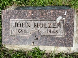
| Inscription | : | Mother of Ronnie - Colin - Gary Molzen. |
| Description | : | Elk Point, S. D. - Edith M. Smith, 88, of Elk Point died Monday, March 18, 2002, at Sioux Valley Hospital In Sioux Falls, S. D. Services will be 10 a.m. Thursday at Immanuel Lutheran Church in Elk Point. Visitation will be 6 to 8 p.m. Wednesday at Anderson Funeral Home In Elk Point. Edith M. Smith, the daughter of Ole and Rachel Olson, was born May 5, 1913, on the family farm in the Richland area near Elk Point. She attended rural school and Elk Point High School. She married John Molzen on Nov.... Read More |
frequently asked questions (FAQ):
-
Where is Edith Olson Molzen-Smith's memorial?
Edith Olson Molzen-Smith's memorial is located at: Saint Paul Cemetery, Elk Point, Union County, USA.
-
When did Edith Olson Molzen-Smith death?
Edith Olson Molzen-Smith death on 18 Mar 2002 in Sioux Falls, Minnehaha County, South Dakota, USA
-
Where are the coordinates of the Edith Olson Molzen-Smith's memorial?
Latitude: 42.7641983
Longitude: -96.7061005
Family Members:
Parent

Spouse
Siblings
Flowers:


Nearby Cemetories:
1. Saint Paul Cemetery
Elk Point, Union County, USA
Coordinate: 42.7641983, -96.7061005
2. Union County Poor Farm Cemetery
Union County, USA
Coordinate: 42.7649210, -96.7077580
3. First Brule Creek Cemetery
Elk Point, Union County, USA
Coordinate: 42.7943993, -96.7069016
4. Richland Cemetery
Richland, Union County, USA
Coordinate: 42.7682991, -96.6624985
5. Gores Bluff Cemetery
Union County, USA
Coordinate: 42.8035069, -96.6260468
6. Ahlsborg Lutheran Cemetery
Union County, USA
Coordinate: 42.8228000, -96.7612000
7. Brule Creek Cemetery
Spink Township, Union County, USA
Coordinate: 42.8346510, -96.7324350
8. Dowlin Cemetery
Burbank, Clay County, USA
Coordinate: 42.7789001, -96.8107986
9. Westfield Township Cemetery
Westfield, Plymouth County, USA
Coordinate: 42.7510986, -96.5914001
10. Elk Point Cemetery
Elk Point, Union County, USA
Coordinate: 42.6794586, -96.6794586
11. Saint Joseph Cemetery
Elk Point, Union County, USA
Coordinate: 42.6794014, -96.6797028
12. Mills Family Cemetery
Westfield, Plymouth County, USA
Coordinate: 42.7188460, -96.6019280
13. Pleasant Hill Cemetery Old
Spink, Union County, USA
Coordinate: 42.8588462, -96.7215592
14. Saint Mary Cemetery
Union County, USA
Coordinate: 42.8520584, -96.7877502
15. Saint Agnes Cemetery
Vermillion, Clay County, USA
Coordinate: 42.7872009, -96.8499985
16. Pleasant Hill Cemetery
Spink, Union County, USA
Coordinate: 42.8741000, -96.6876000
17. Ionia Cemetery
Newcastle, Dixon County, USA
Coordinate: 42.6893997, -96.8300018
18. Gibb's Cemetery
Newcastle, Dixon County, USA
Coordinate: 42.6985100, -96.8518400
19. Saint Patricks Cemetery
Akron, Plymouth County, USA
Coordinate: 42.8232300, -96.5374800
20. Riverside Cemetery
Akron, Plymouth County, USA
Coordinate: 42.8367004, -96.5453033
21. Dewitt Cemetery
Ponca, Dixon County, USA
Coordinate: 42.6248000, -96.7437500
22. Bluff View Cemetery
Vermillion, Clay County, USA
Coordinate: 42.7714000, -96.9056000
23. Saint Agnes Calvary Cemetery
Vermillion, Clay County, USA
Coordinate: 42.7715900, -96.9072100
24. Saint Peter Greenfield Cemetery
Vermillion, Clay County, USA
Coordinate: 42.8608017, -96.8644028