
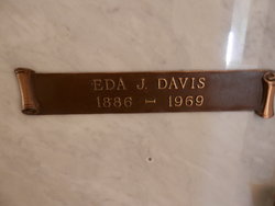
Edna Josephine Clark Davis
| Birth | : | 1886 California, USA |
| Death | : | 14 Dec 1969 Corning, Tehama County, California, USA |
| Burial | : | Red Bluff Memorial Chapel Mausoleum & Columbarium, Red Bluff, Tehama County, USA |
| Coordinate | : | 40.1717130, -122.2466860 |
| Description | : | EDNA J. DAVIS CORNING — Many friends paid their final respects to Mrs. Eda Josephine Davis, 83, at funeral rites held at 10 a.m. yesterday in the First Presbyterian Church, with the Rev. James A. Knox officiating. Mrs. Davis, a lifelong resident of the Corning area, died Sunday afternoon in Corning Memorial Hospital, following a lengthy illness. Active pallbeaiers were Joe Dunn, Roy Williams, Clifford Williams, Don Smith, Ted LaMusga and John Pryatel. Honorary pallbearers were Byron S. Jobe, Walter Fitzpatrick, Elmer Jennings, John Payne, William Winter, Bill Flournoy, Roy Sutfin, Omar Les Sutfln, Louis Pryatel and George Wurster. Entombment was in the Red... Read More |
frequently asked questions (FAQ):
-
Where is Edna Josephine Clark Davis's memorial?
Edna Josephine Clark Davis's memorial is located at: Red Bluff Memorial Chapel Mausoleum & Columbarium, Red Bluff, Tehama County, USA.
-
When did Edna Josephine Clark Davis death?
Edna Josephine Clark Davis death on 14 Dec 1969 in Corning, Tehama County, California, USA
-
Where are the coordinates of the Edna Josephine Clark Davis's memorial?
Latitude: 40.1717130
Longitude: -122.2466860
Family Members:
Flowers:


Nearby Cemetories:
1. Red Bluff Memorial Chapel Mausoleum & Columbarium
Red Bluff, Tehama County, USA
Coordinate: 40.1717130, -122.2466860
2. Oak Hill Cemetery
Red Bluff, Tehama County, USA
Coordinate: 40.1699982, -122.2433014
3. Saint Mary's Cemetery
Red Bluff, Tehama County, USA
Coordinate: 40.1716995, -122.2521973
4. Growney Ranch Family Cemetery
Red Bluff, Tehama County, USA
Coordinate: 40.1167300, -122.1952500
5. Los Molinos Cemetery
Los Molinos, Tehama County, USA
Coordinate: 40.0475650, -122.1011820
6. Red Bank Cemetery
Red Bank, Tehama County, USA
Coordinate: 40.1036970, -122.4458540
7. Tehama Cemetery
Tehama, Tehama County, USA
Coordinate: 40.0233002, -122.1433029
8. Inks Creek Cemetery
Tehama County, USA
Coordinate: 40.3419800, -122.1297100
9. Cottonwood Creek Ranch Cemetery
Cottonwood, Shasta County, USA
Coordinate: 40.3663100, -122.2598800
10. Cottonwood Cemetery
Cottonwood, Shasta County, USA
Coordinate: 40.3856100, -122.2936500
11. Major Pierson B Reading Family Cemetery
Cottonwood, Shasta County, USA
Coordinate: 40.3924300, -122.2126900
12. Sleepy Hollow Pet Cemetery
Anderson, Shasta County, USA
Coordinate: 40.4199430, -122.2858410
13. Sunset Hill Cemetery
Corning, Tehama County, USA
Coordinate: 39.9271600, -122.1586100
14. Rosewood Cemetery
Rosewood, Tehama County, USA
Coordinate: 40.2685360, -122.5575190
15. New Clairvaux Abbey Cemetery
Vina, Tehama County, USA
Coordinate: 39.9381450, -122.0641890
16. Anderson District Cemetery
Anderson, Shasta County, USA
Coordinate: 40.4419518, -122.2967300
17. Oddfellows Cemetery
Anderson, Shasta County, USA
Coordinate: 40.4431590, -122.2907070
18. Anderson Pioneer Cemetery
Anderson, Shasta County, USA
Coordinate: 40.4439011, -122.2904968
19. Vina Cemetery
Vina, Tehama County, USA
Coordinate: 39.9636440, -121.9957070
20. Lowrey Cemetery
Tehama County, USA
Coordinate: 40.0066986, -122.5635986
21. Parkville Cemetery
Anderson, Shasta County, USA
Coordinate: 40.4640200, -122.1897500
22. Cameron-Davis Cemetery
Tehama County, USA
Coordinate: 40.2709800, -121.8778500
23. Lanes Valley Cemetery
Paynes Creek, Tehama County, USA
Coordinate: 40.3998400, -121.9762400
24. Pinckney Cemetery
Cottonwood, Shasta County, USA
Coordinate: 40.3997002, -122.5180969