
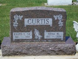
Edna Mae Paxton Curtis
| Birth | : | 6 Mar 1917 Akron, Fulton County, Indiana, USA |
| Death | : | 1 Sep 2004 Rochester, Fulton County, Indiana, USA |
| Burial | : | Prospect Hill Cemetery, Omaha, Douglas County, USA |
| Coordinate | : | 41.2780991, -95.9593964 |
| Plot | : | Section 11 Row 4 |
| Description | : | Published in The Rochester Sentinel Thursday, September 2, 2004 Edna Mae Curtis March 6, 1917-Sept. 1, 2004 Edna Mae CURTIS, 87, Wynnfield Crossing, 1729 Wabash Avenue, Rochester, passed away at 10:03 p.m. Wednesday, at Hickory Creek of Rochester nursing home where she was a patient. Born near Akron to Russell and Jesse Landis Paxton, she married Ralph Curtis on Sept. 5, 1936, in Akron. He preceded her in death on July 17, 1990. Mrs. Curtis was a homemaker and resided in Fulton County for most of her life except when she lived in Indianapolis for two years. She... Read More |
frequently asked questions (FAQ):
-
Where is Edna Mae Paxton Curtis's memorial?
Edna Mae Paxton Curtis's memorial is located at: Prospect Hill Cemetery, Omaha, Douglas County, USA.
-
When did Edna Mae Paxton Curtis death?
Edna Mae Paxton Curtis death on 1 Sep 2004 in Rochester, Fulton County, Indiana, USA
-
Where are the coordinates of the Edna Mae Paxton Curtis's memorial?
Latitude: 41.2780991
Longitude: -95.9593964
Family Members:
Parent
Spouse

Children


Flowers:


Nearby Cemetories:
1. Prospect Hill Cemetery
Omaha, Douglas County, USA
Coordinate: 41.2780991, -95.9593964
2. Nash Chapel Crypt
Omaha, Douglas County, USA
Coordinate: 41.2665090, -95.9721790
3. First Central Congregational Columbarium
Omaha, Douglas County, USA
Coordinate: 41.2563456, -95.9658365
4. Trinity Cathedral Columbarium
Omaha, Douglas County, USA
Coordinate: 41.2603900, -95.9393660
5. Golden Hill Cemetery
Omaha, Douglas County, USA
Coordinate: 41.3050003, -95.9744034
6. Holy Sepulchre Cemetery
Omaha, Douglas County, USA
Coordinate: 41.2543983, -95.9875031
7. Douglas County Poor Farm Cemetery
Omaha, Douglas County, USA
Coordinate: 41.2437240, -95.9723480
8. Pleasant Hill Jewish Cemetery
Omaha, Douglas County, USA
Coordinate: 41.3185997, -95.9766998
9. Bohemian Cemetery
Omaha, Douglas County, USA
Coordinate: 41.2388992, -95.9955978
10. Springwell Cemetery
Omaha, Douglas County, USA
Coordinate: 41.3114014, -96.0096970
11. Westlawn-Hillcrest Memorial Park
Omaha, Douglas County, USA
Coordinate: 41.2346992, -95.9966965
12. Forest Lawn Memorial Park
Omaha, Douglas County, USA
Coordinate: 41.3272018, -95.9847031
13. Servants of Mary Cemetery
Omaha, Douglas County, USA
Coordinate: 41.3017170, -96.0258260
14. Ak-Sar-Ben Racetrack Grounds
Omaha, Douglas County, USA
Coordinate: 41.2414703, -96.0159607
15. Mormon Pioneer Cemetery
Omaha, Douglas County, USA
Coordinate: 41.3348450, -95.9663720
16. Potter Field
Omaha, Douglas County, USA
Coordinate: 41.3320274, -95.9902878
17. Mount Hope Cemetery
Omaha, Douglas County, USA
Coordinate: 41.3041992, -96.0310974
18. Mount Sinai Cemetery
Omaha, Douglas County, USA
Coordinate: 41.3116989, -96.0314026
19. Calvary Cemetery
Omaha, Douglas County, USA
Coordinate: 41.2364006, -96.0294037
20. Graceland Park Cemetery
Omaha, Douglas County, USA
Coordinate: 41.2113991, -95.9785995
21. Saint Andrews Episcopal Church Columbarium
Omaha, Douglas County, USA
Coordinate: 41.2492500, -96.0427500
22. Evergreen Memorial Park Cemetery
Omaha, Douglas County, USA
Coordinate: 41.2393990, -96.0355988
23. Resurrection Cemetery
Omaha, Douglas County, USA
Coordinate: 41.2344208, -96.0365448
24. Saint Mary's Cemetery
Omaha, Douglas County, USA
Coordinate: 41.2042007, -95.9646988