Edward Follmuth
| Birth | : | 29 Jul 1889 Manly, Worth County, Iowa, USA |
| Death | : | 6 Sep 1961 Mason City, Cerro Gordo County, Iowa, USA |
| Burial | : | Carrier Cemetery, Summerville, Jefferson County, USA |
| Coordinate | : | 41.1077995, -79.1691971 |
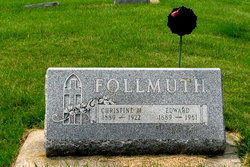
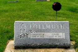
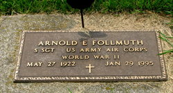
| Description | : | #1 Edward Follmuth – July 2, 1889 – September 6, 1961 EDWARD FOLLMUTH RITES SATURDAY Northwood – Edward Follmuth, 72, died Wednesday in a Mason City hospital. He had lived in this area all his life. He was born in Manly, July 29, 1889, to John and Anna Follmuth. He was a veteran of World War I and was married to Christine Jensen in 1921. She died in 1922. Surviving are a son, Arnold, Northwood; three sisters; Mrs. Anna Clikeman, Terrace, Minnesota; Mrs. Eugene (Minnie) Seater and Miss Anna Follmuth, Northwood; two brothers; John and Lawrence, Northwood. Funeral services will be... Read More |
frequently asked questions (FAQ):
-
Where is Edward Follmuth's memorial?
Edward Follmuth's memorial is located at: Carrier Cemetery, Summerville, Jefferson County, USA.
-
When did Edward Follmuth death?
Edward Follmuth death on 6 Sep 1961 in Mason City, Cerro Gordo County, Iowa, USA
-
Where are the coordinates of the Edward Follmuth's memorial?
Latitude: 41.1077995
Longitude: -79.1691971
Family Members:
Parent
Spouse
Siblings
Children
Flowers:
Nearby Cemetories:
1. Carrier Cemetery
Summerville, Jefferson County, USA
Coordinate: 41.1077995, -79.1691971
2. Vandervort Cemetery
Summerville, Jefferson County, USA
Coordinate: 41.1027985, -79.1828003
3. Mount Pleasant United Methodist Cemetery
Summerville, Jefferson County, USA
Coordinate: 41.1098000, -79.1452000
4. Ohl Cemetery
Ohl, Jefferson County, USA
Coordinate: 41.0833000, -79.1656000
5. Westview Cemetery
Summerville, Jefferson County, USA
Coordinate: 41.1096992, -79.2058029
6. Smith Cemetery
Heathville, Jefferson County, USA
Coordinate: 41.0867004, -79.1996994
7. Conifer Cemetery
Jefferson County, USA
Coordinate: 41.0828018, -79.1427994
8. Jefferson Cemetery
Jefferson County, USA
Coordinate: 41.1409000, -79.1434000
9. Saint Johns Cemetery
Stanton, Jefferson County, USA
Coordinate: 41.1091995, -79.1136017
10. Bethlehem Lutheran Cemetery
Ohl, Jefferson County, USA
Coordinate: 41.0583992, -79.1675415
11. Beaver Run Cemetery
Stanton, Jefferson County, USA
Coordinate: 41.0734634, -79.1145248
12. Zion Cemetery
Langville, Jefferson County, USA
Coordinate: 41.0539017, -79.1753006
13. Shannondale Union Cemetery
Shannondale, Clarion County, USA
Coordinate: 41.0827000, -79.2348000
14. Cliff United Methodist Church Cemetery
Langville, Jefferson County, USA
Coordinate: 41.0545000, -79.1246000
15. Saint Marys Immaculate Conception Cemetery New
Brookville, Jefferson County, USA
Coordinate: 41.1444016, -79.0896988
16. Langville United Methodist Cemetery
Jefferson County, USA
Coordinate: 41.0373000, -79.1763000
17. Paradise Cemetery
Shannondale, Clarion County, USA
Coordinate: 41.0842018, -79.2577972
18. Old Saint Mary's Catholic Cemetery
Brookville, Jefferson County, USA
Coordinate: 41.1472000, -79.0876000
19. Roseville Bethel Cemetery
Roseville, Jefferson County, USA
Coordinate: 41.1752000, -79.1318000
20. Ramsaytown United Methodist Cemetery
Ramsaytown, Jefferson County, USA
Coordinate: 41.0799000, -79.0792000
21. Saint Nicholas Cemetery
Crates, Clarion County, USA
Coordinate: 41.1082993, -79.2675018
22. Living Church Cemetery
Shannondale, Clarion County, USA
Coordinate: 41.0621290, -79.2490830
23. Saint Anns Catholic Cemetery
Corsica, Jefferson County, USA
Coordinate: 41.1789000, -79.2033000
24. Pisgah Cemetery
Corsica, Jefferson County, USA
Coordinate: 41.1789000, -79.2054000


