
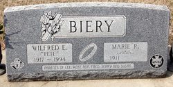
| Birth | : | 26 Oct 1940 Cloud County, Kansas, USA |
| Death | : | 12 Jan 2016 Clyde, Cloud County, Kansas, USA |
| Burial | : | Mount Calvary Cemetery, Clyde, Cloud County, USA |
| Coordinate | : | 39.5917015, -97.4143982 |
| Description | : | Chaput-Buoy Funeral Home Edward Lee Biery, age 75, entered into rest on, January 12, 2016 at his residence. He was born October 26, 1940 in Rural St. Joseph, Kansas to Wilfred E. and Marie R. (Patenaude) Biery. Lee was a 1958 graduate of Clyde High School. He married Betty Kegle on November 28, 1959 in Clyde, Kansas. Lee received a degree in Tele-communications in Wichita, Kansas. He worked for AT&T for 23 years as a Systems Analyst. In 1983 Lee retired and moved to Clyde and owned and operated Lee’s Country Market for 12 years. Lee was also a Real Estate... Read More |
frequently asked questions (FAQ):
-
Where is Edward Lee “Lee "Poppee"” Biery's memorial?
Edward Lee “Lee "Poppee"” Biery's memorial is located at: Mount Calvary Cemetery, Clyde, Cloud County, USA.
-
When did Edward Lee “Lee "Poppee"” Biery death?
Edward Lee “Lee "Poppee"” Biery death on 12 Jan 2016 in Clyde, Cloud County, Kansas, USA
-
Where are the coordinates of the Edward Lee “Lee "Poppee"” Biery's memorial?
Latitude: 39.5917015
Longitude: -97.4143982
Family Members:
Parent
Flowers:


Nearby Cemetories:
1. Mount Calvary Cemetery
Clyde, Cloud County, USA
Coordinate: 39.5917015, -97.4143982
2. Mount Hope Cemetery
Clyde, Cloud County, USA
Coordinate: 39.5969009, -97.4116974
3. Cedar Grove Cemetery
Clyde, Cloud County, USA
Coordinate: 39.5494003, -97.4056015
4. Pleasant View Cemetery
Ames, Cloud County, USA
Coordinate: 39.5346985, -97.4431000
5. Walnut Grove Cemetery
Cloud County, USA
Coordinate: 39.5699997, -97.4993973
6. Saint Joseph Cemetery
Saint Joseph, Cloud County, USA
Coordinate: 39.5074941, -97.4022328
7. Agenda Cemetery
Agenda, Republic County, USA
Coordinate: 39.6761017, -97.4336014
8. Green Mound Cemetery
Rice, Cloud County, USA
Coordinate: 39.5248450, -97.5081630
9. Hollis Cemetery
Cloud County, USA
Coordinate: 39.6383018, -97.5361023
10. Beck Family Cemetery
Agenda, Republic County, USA
Coordinate: 39.6818000, -97.4863000
11. Rice Cemetery
Rice, Cloud County, USA
Coordinate: 39.5614014, -97.5552979
12. Nelson Cemetery
Rice, Cloud County, USA
Coordinate: 39.5257988, -97.5410995
13. Riverdale Cemetery
Clay County, USA
Coordinate: 39.5106010, -97.2930984
14. Saint Peters Cemetery
Aurora, Cloud County, USA
Coordinate: 39.4763985, -97.5180969
15. Princeville Cemetery
Aurora, Cloud County, USA
Coordinate: 39.4672012, -97.5010986
16. Iwacura Cemetery
Morganville, Clay County, USA
Coordinate: 39.4550000, -97.3510000
17. Union Cemetery
Wayne, Republic County, USA
Coordinate: 39.6977997, -97.5457993
18. Willoughby Cemetery
Agenda, Republic County, USA
Coordinate: 39.7402992, -97.4244003
19. French Presbyterian Church Cemetery
Cloud County, USA
Coordinate: 39.4395200, -97.4148290
20. Gotland Cemetery
Sibley Township, Cloud County, USA
Coordinate: 39.6091995, -97.6125031
21. Sherman Cemetery
Morganville, Clay County, USA
Coordinate: 39.5316300, -97.2243700
22. Zion Cemetery
Agenda, Republic County, USA
Coordinate: 39.6749992, -97.5939026
23. Rose Hill Cemetery
Wayne, Republic County, USA
Coordinate: 39.7111015, -97.5661011
24. Minersville Cemetery
Talmo, Republic County, USA
Coordinate: 39.6568330, -97.6229250