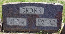
Edward N. “Ed” Cronk
| Birth | : | 19 Feb 1905 Missouri, USA |
| Death | : | 17 Apr 1978 Haakon County, South Dakota, USA |
| Burial | : | Mosswood Cemetery, Cotuit, Barnstable County, USA |
| Coordinate | : | 41.6279984, -70.4303970 |
| Plot | : | G-3 |
| Description | : | Died at his home nine miles east of Philip. |
frequently asked questions (FAQ):
-
Where is Edward N. “Ed” Cronk's memorial?
Edward N. “Ed” Cronk's memorial is located at: Mosswood Cemetery, Cotuit, Barnstable County, USA.
-
When did Edward N. “Ed” Cronk death?
Edward N. “Ed” Cronk death on 17 Apr 1978 in Haakon County, South Dakota, USA
-
Where are the coordinates of the Edward N. “Ed” Cronk's memorial?
Latitude: 41.6279984
Longitude: -70.4303970
Family Members:
Spouse
Flowers:
Nearby Cemetories:
1. Mosswood Cemetery
Cotuit, Barnstable County, USA
Coordinate: 41.6279984, -70.4303970
2. Coombs Cemetery
Mashpee, Barnstable County, USA
Coordinate: 41.6417370, -70.4570980
3. Mashpee Town Cemetery
Mashpee, Barnstable County, USA
Coordinate: 41.6242981, -70.4787979
4. Marstons Mills Cemetery
Marstons Mills, Barnstable County, USA
Coordinate: 41.6612015, -70.4080963
5. Hillside Cemetery
Osterville, Barnstable County, USA
Coordinate: 41.6316700, -70.3787100
6. Saint Peters Episcopal Church Memorial Garden
Barnstable, Barnstable County, USA
Coordinate: 41.6209700, -70.3735800
7. Lakewood Cemetery
Mashpee, Barnstable County, USA
Coordinate: 41.6530991, -70.4783020
8. Great Neck Woods Cemetery
Mashpee, Barnstable County, USA
Coordinate: 41.6054000, -70.4835600
9. Attaquin Cemetery
Mashpee, Barnstable County, USA
Coordinate: 41.6517296, -70.4883881
10. Wakeby Cemetery
Sandwich, Barnstable County, USA
Coordinate: 41.6725500, -70.4723100
11. Boardley Road Cemetery
Sandwich, Barnstable County, USA
Coordinate: 41.6870003, -70.4559021
12. Percival Cemetery
Sandwich, Barnstable County, USA
Coordinate: 41.6883011, -70.4557037
13. Francis Family Cemetery
Mashpee, Barnstable County, USA
Coordinate: 41.6807900, -70.4816600
14. Congregational Cemetery
Barnstable, Barnstable County, USA
Coordinate: 41.6459007, -70.3461990
15. Beechwood Cemetery
Centerville, Barnstable County, USA
Coordinate: 41.6561012, -70.3491974
16. Centerville Ancient Cemetery
Centerville, Barnstable County, USA
Coordinate: 41.6547012, -70.3429031
17. Animal Inn Pet Cemetery
Forestdale, Barnstable County, USA
Coordinate: 41.6754200, -70.5070100
18. Saint Francis Xavier Cemetery
Centerville, Barnstable County, USA
Coordinate: 41.6516991, -70.3331985
19. Crocker Park Cemetery
Barnstable, Barnstable County, USA
Coordinate: 41.6959000, -70.3780975
20. West Parish Burial Ground
West Barnstable, Barnstable County, USA
Coordinate: 41.6984200, -70.3842920
21. Tobey Cemetery
Forestdale, Barnstable County, USA
Coordinate: 41.6972008, -70.4875031
22. Forestdale Cemetery
Forestdale, Barnstable County, USA
Coordinate: 41.6903000, -70.5024033
23. Bay View Cemetery
Waquoit Village, Barnstable County, USA
Coordinate: 41.5815720, -70.5268460
24. West Barnstable Cemetery
West Barnstable, Barnstable County, USA
Coordinate: 41.7080994, -70.3728027


