

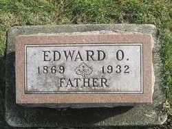
Edward O Esslinger
| Birth | : | 24 Jan 1869 Henry County, Illinois, USA |
| Death | : | Oct 1932 Chapin, Franklin County, Iowa, USA |
| Burial | : | Way Side Cemetery, Chapin, Franklin County, USA |
| Coordinate | : | 42.8293991, -93.2225037 |
| Description | : | Esslinger Funeral Is Held In Chapin Church CHAPIN, Oct. 19. Funeral services were held for Edward O. Esslinger at his home yesterday afternoon In charge of the Rev. Alec Russell. Mr. Esslinger was a pioneer businessman engaged in the barber business for more than 35 years and was a charter member of the M. W. A. fraternity. He was active In political affairs of the community and for many years served as clerk of Ross township. For the past 15 years he was substitute rural letter carrier. On Nov. 3, 1897 he was married to Lucy A. Smith of Coldwater.... Read More |
frequently asked questions (FAQ):
-
Where is Edward O Esslinger's memorial?
Edward O Esslinger's memorial is located at: Way Side Cemetery, Chapin, Franklin County, USA.
-
When did Edward O Esslinger death?
Edward O Esslinger death on Oct 1932 in Chapin, Franklin County, Iowa, USA
-
Where are the coordinates of the Edward O Esslinger's memorial?
Latitude: 42.8293991
Longitude: -93.2225037
Family Members:
Parent
Spouse
Siblings

Children

Flowers:


Nearby Cemetories:
1. Way Side Cemetery
Chapin, Franklin County, USA
Coordinate: 42.8293991, -93.2225037
2. Old Chapin Cemetery
Chapin, Franklin County, USA
Coordinate: 42.8232994, -93.2624969
3. Trinity Lutheran Cemetery
Hampton, Franklin County, USA
Coordinate: 42.7667007, -93.2518997
4. Zion Reformed Church Cemetery
Franklin County, USA
Coordinate: 42.8413887, -93.3188934
5. Hillside Cemetery
Sheffield, Franklin County, USA
Coordinate: 42.9006004, -93.2007980
6. Shobes Grove Cemetery
Franklin County, USA
Coordinate: 42.9000015, -93.2722168
7. Hampton Cemetery
Hampton, Franklin County, USA
Coordinate: 42.7452812, -93.1975021
8. Saint John Zion Cemetery
Sheffield, Franklin County, USA
Coordinate: 42.8969002, -93.1472015
9. Marion Center Cemetery
Latimer, Franklin County, USA
Coordinate: 42.7738991, -93.3178024
10. Hansell Cemetery
Franklin County, USA
Coordinate: 42.7666702, -93.1047211
11. West Fork Cemetery
Franklin County, USA
Coordinate: 42.8918991, -93.0836029
12. Saint Pauls Evangelical Lutheran Cemetery
Latimer, Franklin County, USA
Coordinate: 42.7652817, -93.3719406
13. Sacred Heart Cemetery
Rockwell, Cerro Gordo County, USA
Coordinate: 42.9592018, -93.1913986
14. Richland Lutheran Cemetery
Thornton, Cerro Gordo County, USA
Coordinate: 42.9086113, -93.3683319
15. Saint Johns Lutheran Cemetery
Hampton, Franklin County, USA
Coordinate: 42.7197189, -93.3397217
16. Pleasant Valley Township Cemetery
Swaledale, Cerro Gordo County, USA
Coordinate: 42.9505615, -93.3216705
17. Coulter Cemetery
Coulter, Franklin County, USA
Coordinate: 42.7388916, -93.3716736
18. Towle Cemetery
Geneva, Franklin County, USA
Coordinate: 42.6836014, -93.1785965
19. Rockwell Cemetery
Rockwell, Cerro Gordo County, USA
Coordinate: 42.9786000, -93.1919000
20. Lindenwood Cemetery
Geneva, Franklin County, USA
Coordinate: 42.6935997, -93.1235962
21. Saint Peter's Lutheran Church Cemetery
Coulter, Franklin County, USA
Coordinate: 42.7167015, -93.3803024
22. Harlan Cemetery
Dumont, Butler County, USA
Coordinate: 42.7663994, -93.0143967
23. Four Mile Grove Cemetery
Geneva, Franklin County, USA
Coordinate: 42.6949997, -93.0852966
24. Saint Patricks Catholic Cemetery
Dougherty, Cerro Gordo County, USA
Coordinate: 42.9227791, -93.0294418