
| Birth | : | 16 Aug 1921 Topeka, Shawnee County, Kansas, USA |
| Death | : | 1 Jun 1995 Houston, Harris County, Texas, USA |
| Burial | : | Memorial Park Cemetery, Lawrence, Douglas County, USA |
| Coordinate | : | 38.9552994, -95.2153015 |
| Plot | : | Section Acacia D, Lot 166, Graves 4,5,6 |
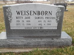
| Inscription | : | Edwin T Bodin Pvt US Army Air Corps World War II Aug 16 1921 Jun 1 1995 |
| Description | : | ****************************************** Lawrence Journal-World (KS) - Thursday, June 22, 1995 Deceased Name: EDWIN T. BODIN Memorial services for Edwin T. Bodin, 73, Houston, were held Wednesday in Memorial Park Cemetery. He was cremated. Mr. Bodin died June 1, 1995, at his home. He was born Aug. 18, 1922, in Topeka, the son of William and Raye Cantrall Bodin. He grew up in Lawrence and was an Eagle Boy Scout and a crucifer at Trinity Episcopal Church in Lawrence. He traveled widely during World War II with the Air Transport Command as a flight engineer. He was retired from The Garrett Corp., where... Read More |
frequently asked questions (FAQ):
-
Where is Edward T Bodin's memorial?
Edward T Bodin's memorial is located at: Memorial Park Cemetery, Lawrence, Douglas County, USA.
-
When did Edward T Bodin death?
Edward T Bodin death on 1 Jun 1995 in Houston, Harris County, Texas, USA
-
Where are the coordinates of the Edward T Bodin's memorial?
Latitude: 38.9552994
Longitude: -95.2153015
Family Members:
Parent

Siblings
Flowers:


Nearby Cemetories:
1. Memorial Park Cemetery
Lawrence, Douglas County, USA
Coordinate: 38.9552994, -95.2153015
2. Mount Calvary Catholic Cemetery
Lawrence, Douglas County, USA
Coordinate: 38.9580002, -95.2139969
3. Oak Hill Cemetery
Lawrence, Douglas County, USA
Coordinate: 38.9589005, -95.2118988
4. Trinity Episcopal Church Columbarium
Lawrence, Douglas County, USA
Coordinate: 38.9653893, -95.2373886
5. Saint Johns Catholic Cemetery
Douglas County, USA
Coordinate: 38.9437900, -95.1919600
6. Dyche Hall Natural History Museum
Lawrence, Douglas County, USA
Coordinate: 38.9584800, -95.2434800
7. Haskell Cemetery
Lawrence, Douglas County, USA
Coordinate: 38.9353790, -95.2284241
8. Franklin Cemetery
Douglas County, USA
Coordinate: 38.9437523, -95.1869431
9. Pioneer Cemetery
Lawrence, Douglas County, USA
Coordinate: 38.9528008, -95.2611008
10. First Presbyterian Church Memorial Garden
Lawrence, Douglas County, USA
Coordinate: 38.9414900, -95.2641600
11. County Poor Farm Cemetery
Douglas County, USA
Coordinate: 38.9119400, -95.2214600
12. Kennedy Cemetery
Douglas County, USA
Coordinate: 38.9112900, -95.2269200
13. Maple Grove Cemetery
Lawrence, Douglas County, USA
Coordinate: 39.0018997, -95.2316971
14. Adams Cemetery
Douglas County, USA
Coordinate: 38.9955400, -95.2509100
15. Blue Mound Cemetery
Lawrence, Douglas County, USA
Coordinate: 38.9046600, -95.1865400
16. Davis Cemetery
Lawrence, Douglas County, USA
Coordinate: 38.9722500, -95.2831100
17. Marshall Cemetery
Douglas County, USA
Coordinate: 38.9040800, -95.2446700
18. Dutton Cemetery
Douglas County, USA
Coordinate: 38.8989800, -95.2790600
19. Luckan Family Cemetery
Fall Leaf, Leavenworth County, USA
Coordinate: 38.9808500, -95.1128000
20. Corpus Christi Catholic Church Columbarium
Lawrence, Douglas County, USA
Coordinate: 38.9572250, -95.3238450
21. Cemetery Beni Israel
Eudora, Douglas County, USA
Coordinate: 38.9280128, -95.1122208
22. Lyon Family Cemetery
Lawrence, Douglas County, USA
Coordinate: 38.9877440, -95.3166530
23. Richland Cemetery
Lawrence, Douglas County, USA
Coordinate: 38.8768997, -95.2630997
24. Southwest City Cemetery
Eudora, Douglas County, USA
Coordinate: 38.9334800, -95.1070300