

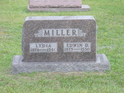
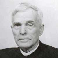
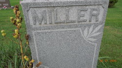
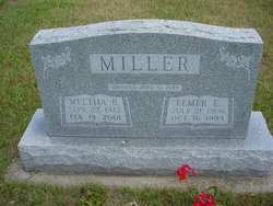
Edwin D. Miller
| Birth | : | 12 Mar 1875 Shipshewana, LaGrange County, Indiana, USA |
| Death | : | 10 Nov 1950 Honeyville, LaGrange County, Indiana, USA |
| Burial | : | Greenwood Cemetery, Birmingham, Oakland County, USA |
| Coordinate | : | 42.5539017, -83.2238998 |
| Description | : | Edwin D. Miller was born on Friday, March 12, 1875 in Newbury Township, Lagrange County, Indiana. He was the 10th child of 13 born to Daniel P. and Anna "Fanny" (Hershberger) Miller. When Ed was 8 years old, his family moved to Cass County, Missouri. They lived there for 4 years and then moved back to Indiana, where they lived about 8 years on a farm east of the Forks Church in Lagrange County. In 1893 when he was 18, Ed went to the Amish-Mennonite settlement at Hopedale, Illinois with 4 other Indiana... Read More |
frequently asked questions (FAQ):
-
Where is Edwin D. Miller's memorial?
Edwin D. Miller's memorial is located at: Greenwood Cemetery, Birmingham, Oakland County, USA.
-
When did Edwin D. Miller death?
Edwin D. Miller death on 10 Nov 1950 in Honeyville, LaGrange County, Indiana, USA
-
Where are the coordinates of the Edwin D. Miller's memorial?
Latitude: 42.5539017
Longitude: -83.2238998
Family Members:
Parent
Spouse
Siblings
Children
Flowers:


Nearby Cemetories:
1. Greenwood Cemetery
Birmingham, Oakland County, USA
Coordinate: 42.5539017, -83.2238998
2. Saint James Episcopal Church Columbarium
Birmingham, Oakland County, USA
Coordinate: 42.5465088, -83.2179642
3. First United Methodist Church Memorial Garden
Birmingham, Oakland County, USA
Coordinate: 42.5454370, -83.2330870
4. First Presbyterian Church Columbarium
Birmingham, Oakland County, USA
Coordinate: 42.5463380, -83.2351040
5. Lutheran Church of the Redeemer Columbarium
Birmingham, Oakland County, USA
Coordinate: 42.5463540, -83.2373950
6. Christ Church Cranbrook Columbarium
Bloomfield Hills, Oakland County, USA
Coordinate: 42.5672188, -83.2440186
7. Perrin Cemetery
Troy, Oakland County, USA
Coordinate: 42.5398254, -83.1857605
8. Clover Hill Park Cemetery
Birmingham, Oakland County, USA
Coordinate: 42.5349998, -83.1885986
9. Acacia Park Cemetery
Beverly Hills, Oakland County, USA
Coordinate: 42.5217018, -83.2197037
10. Bloomfield Hills Cemetery (Defunct)
Bloomfield Hills, Oakland County, USA
Coordinate: 42.5811111, -83.2563889
11. Northbrook Presbyterian Church Columbarium
Beverly Hills, Oakland County, USA
Coordinate: 42.5297550, -83.2657280
12. Gilbert Lake Cemetery (Defunct)
Bloomfield, Oakland County, USA
Coordinate: 42.5568800, -83.2799500
13. Saint Hugo of the Hills Columbarium
Bloomfield Hills, Oakland County, USA
Coordinate: 42.5927391, -83.2477036
14. Beach Cemetery
Troy, Oakland County, USA
Coordinate: 42.5936012, -83.1980972
15. Beekman Cemetery
Southfield, Oakland County, USA
Coordinate: 42.5098076, -83.2176285
16. Crooks Road Cemetery
Troy, Oakland County, USA
Coordinate: 42.5727997, -83.1680984
17. Beautiful Savior Lutheran Church Columbarium
Bloomfield Hills, Oakland County, USA
Coordinate: 42.5984290, -83.2092050
18. Payne-Waugh Cemetery
Bloomfield Township, Oakland County, USA
Coordinate: 42.6044640, -83.2385790
19. Saint David Episcopal Church Columbarium
Southfield, Oakland County, USA
Coordinate: 42.5030990, -83.2096400
20. White Chapel Memorial Park Cemetery
Troy, Oakland County, USA
Coordinate: 42.5856018, -83.1635971
21. Roseland Park Cemetery
Berkley, Oakland County, USA
Coordinate: 42.5060997, -83.1797028
22. Kirk in the Hills Columbarium
Bloomfield Hills, Oakland County, USA
Coordinate: 42.5810394, -83.2942886
23. Saint Andrews Memorial Garden
Clawson, Oakland County, USA
Coordinate: 42.5359612, -83.1460571
24. Franklin Cemetery
Franklin, Oakland County, USA
Coordinate: 42.5224991, -83.3059921