


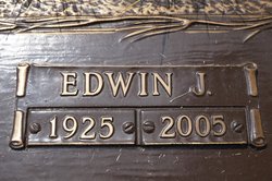
Edwin Kunkel
| Birth | : | 17 Jun 1925 Haverhill, Marshall County, Iowa, USA |
| Death | : | 22 Oct 2005 Marshall County, Iowa, USA |
| Burial | : | Landican Cemetery and Crematorium, Woodchurch, Metropolitan Borough of Wirral, England |
| Coordinate | : | 53.3654000, -3.0887510 |
| Description | : | Edwin Kunkel, 80, of Marshalltown died unexpectedly Saturday, Oct. 22, 2005, at Grandview Nursing Home. Funeral services will be at 10:30 a.m. Thursday, Oct. 27 at St. Henry's Catholic Church with the Father Louis Jaeger officiating. Burial will be in the Rose Hill Memorial Gardens. Following the service, friends are invited for a time of fellowship and refreshments at St. Henry‘s fellowship hall. Friends may call from 6 to 8 p.m. Wednesday at the Mitchell Family Funeral Home. A public scripture service will be at 7 p.m. To offer condolences, please visit www.mitchellfh.com. The Mitchell Family Funeral Home is caring for... Read More |
frequently asked questions (FAQ):
-
Where is Edwin Kunkel's memorial?
Edwin Kunkel's memorial is located at: Landican Cemetery and Crematorium, Woodchurch, Metropolitan Borough of Wirral, England.
-
When did Edwin Kunkel death?
Edwin Kunkel death on 22 Oct 2005 in Marshall County, Iowa, USA
-
Where are the coordinates of the Edwin Kunkel's memorial?
Latitude: 53.3654000
Longitude: -3.0887510
Family Members:
Parent

Spouse
Siblings

Flowers:


Nearby Cemetories:
1. Landican Cemetery and Crematorium
Woodchurch, Metropolitan Borough of Wirral, England
Coordinate: 53.3654000, -3.0887510
2. Holy Cross Churchyard
Woodchurch, Metropolitan Borough of Wirral, England
Coordinate: 53.3731900, -3.0899400
3. Salacre Lane Cemetery
Upton, Metropolitan Borough of Wirral, England
Coordinate: 53.3824050, -3.0919920
4. Saint Mary's Churchyard
Upton, Metropolitan Borough of Wirral, England
Coordinate: 53.3847010, -3.0961600
5. Barnston Cemetery
Barnston, Metropolitan Borough of Wirral, England
Coordinate: 53.3408590, -3.0820730
6. St. John the Divine
Frankby, Metropolitan Borough of Wirral, England
Coordinate: 53.3744200, -3.1330200
7. Heswall Cemetery
Heswall, Metropolitan Borough of Wirral, England
Coordinate: 53.3400420, -3.1102790
8. St Bartholomew's Churchyard
Thurstaston, Metropolitan Borough of Wirral, England
Coordinate: 53.3485750, -3.1320070
9. Frankby Cemetery
Frankby, Metropolitan Borough of Wirral, England
Coordinate: 53.3715920, -3.1399600
10. Flaybrick Memorial Gardens
Birkenhead, Metropolitan Borough of Wirral, England
Coordinate: 53.3968130, -3.0633240
11. Christ Church Churchyard
Moreton, Metropolitan Borough of Wirral, England
Coordinate: 53.3999580, -3.1112310
12. Christ Church
Bebington, Metropolitan Borough of Wirral, England
Coordinate: 53.3584460, -3.0254810
13. St Oswald's Churchyard
Bidston, Metropolitan Borough of Wirral, England
Coordinate: 53.4043400, -3.0791000
14. St Peter's Churchyard
Heswall, Metropolitan Borough of Wirral, England
Coordinate: 53.3227400, -3.1036400
15. Bebington Cemetery
Bebington, Metropolitan Borough of Wirral, England
Coordinate: 53.3588030, -3.0165370
16. St Paul's
Tranmere, Metropolitan Borough of Wirral, England
Coordinate: 53.3740000, -3.0154600
17. St. Werburgh & St. Laurence Catholic Churchyard
Birkenhead, Metropolitan Borough of Wirral, England
Coordinate: 53.3894910, -3.0217530
18. Grange Cemetery
West Kirby, Metropolitan Borough of Wirral, England
Coordinate: 53.3751630, -3.1682120
19. St. Peter's Churchyard
Bebington, Metropolitan Borough of Wirral, England
Coordinate: 53.3692500, -3.0021020
20. St. Mary's Churchyard
Birkenhead, Metropolitan Borough of Wirral, England
Coordinate: 53.3895930, -3.0112520
21. All Saints Churchyard
Thornton Hough, Metropolitan Borough of Wirral, England
Coordinate: 53.3203500, -3.0444780
22. St Bridget Churchyard
West Kirby, Metropolitan Borough of Wirral, England
Coordinate: 53.3687130, -3.1764480
23. St Andrews Parish Churchyard
Bebington, Metropolitan Borough of Wirral, England
Coordinate: 53.3479800, -3.0035400
24. Christ Church Churchyard
Port Sunlight, Metropolitan Borough of Wirral, England
Coordinate: 53.3534920, -2.9953750