
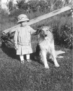

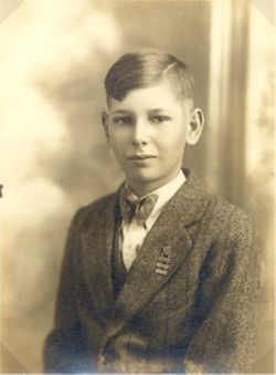

Eldon Harold Williams
| Birth | : | 11 Jul 1915 Maryville, Nodaway County, Missouri, USA |
| Death | : | 6 Jul 1977 Maryville, Nodaway County, Missouri, USA |
| Burial | : | Woodlawn Cemetery, Clinton, Worcester County, USA |
| Coordinate | : | 42.4185982, -71.6889038 |
| Plot | : | Garden of the Cross Section B |
frequently asked questions (FAQ):
-
Where is Eldon Harold Williams's memorial?
Eldon Harold Williams's memorial is located at: Woodlawn Cemetery, Clinton, Worcester County, USA.
-
When did Eldon Harold Williams death?
Eldon Harold Williams death on 6 Jul 1977 in Maryville, Nodaway County, Missouri, USA
-
Where are the coordinates of the Eldon Harold Williams's memorial?
Latitude: 42.4185982
Longitude: -71.6889038
Family Members:
Parent

Spouse

Siblings
Children
Flowers:

Miss you lots daddy.
Left by Anonymous on 27 Nov 2013

Left by Anonymous on 07 Jun 2015

Hansom Eldon, This is my hansom daddy. I hope you find him. He will make you smile and feel loved. There is no bond like that special bond between daddies and their little girls.
Left by Anonymous on 20 Jun 2015

Left by Anonymous on 25 Jun 2015

Rest peacefully with the Lord
Left by Anonymous on 19 Mar 2017

Left by Anonymous on 18 Apr 2018

Happy Birthday Daddy!
Left by Anonymous on 12 Jul 2018


Nearby Cemetories:
1. Woodlawn Cemetery
Clinton, Worcester County, USA
Coordinate: 42.4185982, -71.6889038
2. Saint John's Cemetery
Lancaster, Worcester County, USA
Coordinate: 42.4328003, -71.6977997
3. Reservoir Pines Cemetery
Clinton, Worcester County, USA
Coordinate: 42.4084900, -71.7109700
4. Old Common Burial Ground
Lancaster, Worcester County, USA
Coordinate: 42.4426700, -71.6645300
5. Fairbank Burial Ground
Sterling, Worcester County, USA
Coordinate: 42.4152600, -71.7320000
6. Middle Cemetery
Lancaster, Worcester County, USA
Coordinate: 42.4491997, -71.6757965
7. Old Settlers Burial Yard
Lancaster, Worcester County, USA
Coordinate: 42.4488754, -71.6742706
8. Eastwood Cemetery
Lancaster, Worcester County, USA
Coordinate: 42.4417000, -71.6528015
9. Thayer Cemetery
Lancaster, Worcester County, USA
Coordinate: 42.4578500, -71.7024400
10. Hillside Cemetery
Sterling, Worcester County, USA
Coordinate: 42.4410000, -71.7492570
11. Oak Hill Cemetery
Sterling, Worcester County, USA
Coordinate: 42.4417000, -71.7493973
12. North Cemetery
Berlin, Worcester County, USA
Coordinate: 42.4037000, -71.6225100
13. Old Fry Burying Ground
Bolton, Worcester County, USA
Coordinate: 42.4077300, -71.6209900
14. Chocksett Burial Ground
Sterling, Worcester County, USA
Coordinate: 42.4377000, -71.7555400
15. Friends Burial Ground
Bolton, Worcester County, USA
Coordinate: 42.4133620, -71.6176710
16. West Burying Ground
Bolton, Worcester County, USA
Coordinate: 42.4488983, -71.6300964
17. Old Burying Ground
Berlin, Worcester County, USA
Coordinate: 42.3811646, -71.6375351
18. North Village Cemetery
Lancaster, Worcester County, USA
Coordinate: 42.4724998, -71.6778030
19. Old South Burying Ground
Bolton, Worcester County, USA
Coordinate: 42.4231000, -71.6096500
20. Saint Lukes Cemetery
West Boylston, Worcester County, USA
Coordinate: 42.3833008, -71.7568970
21. Cookshire Cemetery
Sterling, Worcester County, USA
Coordinate: 42.4108500, -71.7734800
22. West Cemetery
Sterling, Worcester County, USA
Coordinate: 42.4514100, -71.7651400
23. South Berlin Cemetery
Berlin, Worcester County, USA
Coordinate: 42.3652992, -71.6292038
24. Pine Grove Cemetery
Boylston, Worcester County, USA
Coordinate: 42.3582993, -71.7431030