
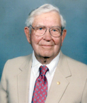


Eldred Reuben Lundquist
| Birth | : | 22 Feb 1914 Stratford, Hamilton County, Iowa, USA |
| Death | : | 20 Mar 2008 Webster City, Hamilton County, Iowa, USA |
| Burial | : | South Marion Cemetery, Stratford, Hamilton County, USA |
| Coordinate | : | 42.2327995, -93.8735962 |
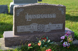
| Description | : | Daily Freeman Journal Webster City, IA March 21, 2008 Eldred R. Lunquist, 94, of Webster City, a former Stanhope farmer, died Thursday, March 20, 2008 at Crestview Senior Living Apartments. Funeral services will be held Saturday, 10:30 a.m. at Foster's Chapel, with Pastor Suzie Moore officiating. Burial will be in the South Marion Cemetery, southwest of Stanhope. Visitation will be two hours before the service. Eldred Reuben Lundquist, son of Victor and Nettie Sealine Lundquist, was born February 22, 1914 at Stanhope. He graduated from Stanhope High School. On August 19, 1938, he married Harriet Peterson at Stratford. The couple farmed 2 miles southwest... Read More |
frequently asked questions (FAQ):
-
Where is Eldred Reuben Lundquist's memorial?
Eldred Reuben Lundquist's memorial is located at: South Marion Cemetery, Stratford, Hamilton County, USA.
-
When did Eldred Reuben Lundquist death?
Eldred Reuben Lundquist death on 20 Mar 2008 in Webster City, Hamilton County, Iowa, USA
-
Where are the coordinates of the Eldred Reuben Lundquist's memorial?
Latitude: 42.2327995
Longitude: -93.8735962
Family Members:
Parent

Spouse

Siblings

Children
Flowers:


Nearby Cemetories:
1. South Marion Cemetery
Stratford, Hamilton County, USA
Coordinate: 42.2327995, -93.8735962
2. Oakwood Cemetery
Stratford, Hamilton County, USA
Coordinate: 42.2942009, -93.9182968
3. Mineral Ridge Cemetery
Ridgeport, Boone County, USA
Coordinate: 42.1749992, -93.9266968
4. Hooks Point Cemetery
Hamilton County, USA
Coordinate: 42.2944530, -93.9199090
5. Hardin Township Cemetery
Hardin Township, Webster County, USA
Coordinate: 42.2411003, -93.9708023
6. Saint Paul Lutheran Cemetery
Boone, Boone County, USA
Coordinate: 42.1700000, -93.8070000
7. Boone County Poor Farm Cemetery
Boone County, USA
Coordinate: 42.1591100, -93.9159000
8. White Cemetery
Boone County, USA
Coordinate: 42.1777992, -93.9636002
9. Lake Center Cemetery
Stanhope, Hamilton County, USA
Coordinate: 42.2482986, -93.7568970
10. Leininger Cemetery
Boone County, USA
Coordinate: 42.1492004, -93.8356018
11. Lawn Hill Cemetery
Stanhope, Hamilton County, USA
Coordinate: 42.2677994, -93.7611008
12. Nesse Cemetery
Hamilton County, USA
Coordinate: 42.3250008, -93.8933029
13. Neese Cemetery
Homer, Hamilton County, USA
Coordinate: 42.3250000, -93.8935000
14. Linn Cemetery
Pilot Mound, Boone County, USA
Coordinate: 42.2045330, -93.9970230
15. Vegors Cemetery
Webster County, USA
Coordinate: 42.3177986, -93.9421997
16. Mackey Cemetery
Boone County, USA
Coordinate: 42.1675000, -93.7565000
17. Runyan Cemetery
Pilot Mound, Boone County, USA
Coordinate: 42.1749992, -94.0015030
18. Saint Pauls Church Cemetery
Jewell, Hamilton County, USA
Coordinate: 42.2490100, -93.7173400
19. Schlicht Cemetery
Fraser, Boone County, USA
Coordinate: 42.1444200, -93.9780100
20. Bass Cemetery
Dayton, Webster County, USA
Coordinate: 42.2966995, -94.0149994
21. Saratoga Cemetery
Stanhope, Hamilton County, USA
Coordinate: 42.3539009, -93.8167038
22. Pilot Mound Cemetery
Pilot Mound, Boone County, USA
Coordinate: 42.1636200, -94.0282600
23. Ellsworth Clear Lake Cemetery
Randall, Hamilton County, USA
Coordinate: 42.2268930, -93.6926200
24. Bass Point Cemetery
Boone, Boone County, USA
Coordinate: 42.0992012, -93.8957977