
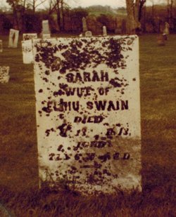
Elihu Swain Sr.
| Birth | : | 25 Jan 1759 Nantucket, Nantucket County, Massachusetts, USA |
| Death | : | 2 Sep 1848 Economy, Wayne County, Indiana, USA |
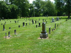
| Burial | : | Economy Cemetery, Economy, Wayne County, USA |
| Coordinate | : | 39.9832993, -85.0942001 |
| Plot | : | Row 13-16 |
| Description | : | Elihu Swain was the 2nd of 6 children of Nathaniel Swain and Bethiah Macy. Elihu Swain moved with his family and other settlers of Nantucket to Guilford County, North Carolina in September 1773. Guilford County was the center of a large colony of the society of friends. About 1800 they moved to Lost Creek, Tennessee (Jefferson County) Where John Mills and William Millikan had started a new colony. This location was 24 miles North-East of present Knoxville, called Friends Station. On August 8, 1815, they moved to Wayne County, Indiana on the southern railway and the old meeting house and school... Read More |
frequently asked questions (FAQ):
-
Where is Elihu Swain Sr.'s memorial?
Elihu Swain Sr.'s memorial is located at: Economy Cemetery, Economy, Wayne County, USA.
-
When did Elihu Swain Sr. death?
Elihu Swain Sr. death on 2 Sep 1848 in Economy, Wayne County, Indiana, USA
-
Where are the coordinates of the Elihu Swain Sr.'s memorial?
Latitude: 39.9832993
Longitude: -85.0942001
Family Members:
Parent
Spouse
Siblings

Children


Flowers:


Nearby Cemetories:
1. Economy Cemetery
Economy, Wayne County, USA
Coordinate: 39.9832993, -85.0942001
2. Jordon Cemetery
Economy, Wayne County, USA
Coordinate: 40.0041490, -85.1209120
3. Bethel United Brethren Cemetery
Economy, Wayne County, USA
Coordinate: 39.9469980, -85.1076720
4. West River Friends Cemetery
Dalton, Wayne County, USA
Coordinate: 39.9826780, -85.1468510
5. Williamson Road Amish Cemetery
Economy, Wayne County, USA
Coordinate: 39.9497920, -85.0629710
6. Little Creek Cemetery
Losantville, Randolph County, USA
Coordinate: 40.0121994, -85.1433029
7. Smith Cemetery
Modoc, Randolph County, USA
Coordinate: 40.0341860, -85.1092390
8. Union Chapel Methodist Cemetery
Carlos, Randolph County, USA
Coordinate: 40.0261002, -85.0519028
9. Olive Branch Cemetery
Hagerstown, Wayne County, USA
Coordinate: 39.9379000, -85.1355560
10. Cook Cemetery
Williamsburg, Wayne County, USA
Coordinate: 39.9853930, -85.0158670
11. Mount Pleasant Cemetery
Wayne County, USA
Coordinate: 39.9903060, -85.0105980
12. Sugar Grove Cemetery
Wayne County, USA
Coordinate: 39.9211006, -85.0721283
13. Salem Cemetery
Modoc, Randolph County, USA
Coordinate: 40.0485850, -85.1097210
14. Nettle Creek Friends Quaker Cemetery
Dalton, Wayne County, USA
Coordinate: 39.9743190, -85.1871830
15. Nettle Creek Baptist Cemetery
Losantville, Randolph County, USA
Coordinate: 40.0077960, -85.1826080
16. Williamsburg Cemetery
Williamsburg, Wayne County, USA
Coordinate: 39.9547005, -85.0036011
17. Tharp Burial Ground
Losantville, Randolph County, USA
Coordinate: 40.0262010, -85.1799630
18. Lewis Family Cemetery
Williamsburg, Wayne County, USA
Coordinate: 39.9403910, -85.0059530
19. Bald Ridge Cemetery
Hagerstown, Wayne County, USA
Coordinate: 39.9009500, -85.1130800
20. Salem Baptist Church Cemetery
Hagerstown, Wayne County, USA
Coordinate: 39.8988991, -85.0971985
21. Ulrich Cemetery
Hagerstown, Wayne County, USA
Coordinate: 39.9433340, -85.1958900
22. Huntsville Cemetery
Modoc, Randolph County, USA
Coordinate: 40.0699043, -85.0752182
23. Bales Cemetery
Mooreland, Henry County, USA
Coordinate: 39.9610370, -85.2055620
24. West Lawn Cemetery
Hagerstown, Wayne County, USA
Coordinate: 39.9138985, -85.1667023