
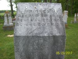
| Birth | : | 4 May 1839 USA |
| Death | : | 24 Jun 1921 Henry County, Ohio, USA |
| Burial | : | Sherwood Cemetery, Sherwood, Defiance County, USA |
| Coordinate | : | 41.2900009, -84.5507965 |
| Description | : | Wife of William Franz |
frequently asked questions (FAQ):
-
Where is Elisabeth Ricker Franz's memorial?
Elisabeth Ricker Franz's memorial is located at: Sherwood Cemetery, Sherwood, Defiance County, USA.
-
When did Elisabeth Ricker Franz death?
Elisabeth Ricker Franz death on 24 Jun 1921 in Henry County, Ohio, USA
-
Where are the coordinates of the Elisabeth Ricker Franz's memorial?
Latitude: 41.2900009
Longitude: -84.5507965
Family Members:
Parent

Spouse
Siblings
Children
Flowers:


Nearby Cemetories:
1. Sherwood Cemetery
Sherwood, Defiance County, USA
Coordinate: 41.2900009, -84.5507965
2. Blair Cemetery
Sherwood, Defiance County, USA
Coordinate: 41.2677994, -84.5436020
3. Saint Stephens New Catholic Cemetery
The Bend, Defiance County, USA
Coordinate: 41.2820100, -84.5150800
4. Glore Cemetery
Sherwood, Defiance County, USA
Coordinate: 41.2639008, -84.5342026
5. Liggett Scouts Burial Ground
The Bend, Defiance County, USA
Coordinate: 41.2761100, -84.5154500
6. Shirley Family Cemetery
The Bend, Defiance County, USA
Coordinate: 41.2821360, -84.5071690
7. Blue Cemetery
The Bend, Defiance County, USA
Coordinate: 41.2871500, -84.5033200
8. Saint Johns Lutheran Cemetery
Sherwood, Defiance County, USA
Coordinate: 41.3092003, -84.5931015
9. Saint Stephens Old Cemetery
Defiance County, USA
Coordinate: 41.2747002, -84.4955978
10. Moats Cemetery
Defiance County, USA
Coordinate: 41.3330420, -84.5194530
11. Colby Cemetery
Defiance County, USA
Coordinate: 41.2532997, -84.5952988
12. Eaton Cemetery
Paulding County, USA
Coordinate: 41.2402992, -84.5783005
13. Funk Cemetery
Defiance County, USA
Coordinate: 41.3396988, -84.5164032
14. Auglaize Village Cemetery
Defiance, Defiance County, USA
Coordinate: 41.3399760, -84.5165610
15. Hill Cemetery
Sherwood, Defiance County, USA
Coordinate: 41.2824550, -84.4687870
16. Immaculate Conception Cemetery
Crane Township, Paulding County, USA
Coordinate: 41.2325500, -84.5905100
17. Rochester Cemetery
Cecil, Paulding County, USA
Coordinate: 41.2313995, -84.5914001
18. Tuttle Cemetery
Defiance, Defiance County, USA
Coordinate: 41.2756004, -84.4475021
19. Lintz Cemetery
Ney, Defiance County, USA
Coordinate: 41.3760986, -84.5402985
20. Renollet Cemetery
Paulding County, USA
Coordinate: 41.2122002, -84.5000000
21. Pioneer Cemetery
Defiance County, USA
Coordinate: 41.2641200, -84.4404200
22. Gordon Cemetery
Paulding County, USA
Coordinate: 41.2318993, -84.6433029
23. Blair-Adams Sun Valley Cemetery
Cecil, Paulding County, USA
Coordinate: 41.2177180, -84.4772200
24. Marysdale Immaculate Conception Catholic Cemetery
Ney, Defiance County, USA
Coordinate: 41.3499985, -84.4580994