
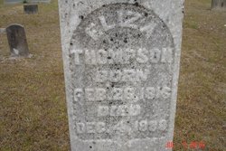
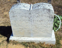
Eliza Myers Thompson
| Birth | : | 26 Feb 1816 Orangeburg County, South Carolina, USA |
| Death | : | 4 Dec 1888 Orangeburg County, South Carolina, USA |
| Burial | : | St. John of Beverley Churchyard, Whatton, Rushcliffe Borough, England |
| Coordinate | : | 52.9493000, -0.8926000 |
frequently asked questions (FAQ):
-
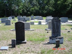
Where is Eliza Myers Thompson's memorial?
Eliza Myers Thompson's memorial is located at: St. John of Beverley Churchyard, Whatton, Rushcliffe Borough, England.
-
When did Eliza Myers Thompson death?
Eliza Myers Thompson death on 4 Dec 1888 in Orangeburg County, South Carolina, USA
-
Where are the coordinates of the Eliza Myers Thompson's memorial?
Latitude: 52.9493000
Longitude: -0.8926000
Family Members:
Spouse
Children
Flowers:


Nearby Cemetories:
1. St. John of Beverley Churchyard
Whatton, Rushcliffe Borough, England
Coordinate: 52.9493000, -0.8926000
2. St John of Beverley Churchyard
Scarrington, Rushcliffe Borough, England
Coordinate: 52.9667400, -0.9071900
3. St Mary's Churchyard
Orston, Rushcliffe Borough, England
Coordinate: 52.9622500, -0.8560300
4. All Saints Churchyard
Granby, Rushcliffe Borough, England
Coordinate: 52.9180770, -0.8847700
5. St Mary and All Saints Churchyard
Bingham, Rushcliffe Borough, England
Coordinate: 52.9522920, -0.9484950
6. St Mary & All Saints Churchyard
Hawksworth, Rushcliffe Borough, England
Coordinate: 52.9831700, -0.8800500
7. St Peter's Churchyard
Flawborough, Rushcliffe Borough, England
Coordinate: 52.9773700, -0.8365800
8. St Andrews Churchyard
Langar, Rushcliffe Borough, England
Coordinate: 52.9034742, -0.9259344
9. Barkestone le Vale St Peter & St Paul
Barkestone, Melton Borough, England
Coordinate: 52.9062600, -0.8450200
10. St Mary & All Saints Churchyard
Shelton, Rushcliffe Borough, England
Coordinate: 52.9932200, -0.8389300
11. St. Helen's Churchyard
Plungar, Melton Borough, England
Coordinate: 52.8986260, -0.8569390
12. St. Mary the Virgin Churchyard
Bottesford, Melton Borough, England
Coordinate: 52.9434270, -0.8001460
13. St Mary's Churchyard
Kilvington, Newark and Sherwood District, England
Coordinate: 52.9772500, -0.8092250
14. Saint Peter Churchyard
East Bridgford, Rushcliffe Borough, England
Coordinate: 52.9809170, -0.9726560
15. St Peter Churchyard
Redmile, Melton Borough, England
Coordinate: 52.9113200, -0.8161530
16. St Giles Churchyard
Cropwell Bishop, Rushcliffe Borough, England
Coordinate: 52.9127600, -0.9831300
17. All Saints Churchyard
Syerston, Newark and Sherwood District, England
Coordinate: 53.0194600, -0.8884800
18. St John the Baptist Gunthorpe
Gunthorpe, Newark and Sherwood District, England
Coordinate: 52.9925600, -0.9877400
19. Shelford Priory
Shelford, Rushcliffe Borough, England
Coordinate: 52.9830600, -0.9994100
20. St Michael Churchyard
Hoveringham, Newark and Sherwood District, England
Coordinate: 53.0124370, -0.9603240
21. St Mary the Virgin Churchyard
Harby, Melton Borough, England
Coordinate: 52.8739600, -0.8912030
22. All Saints Churchyard
Elston, Newark and Sherwood District, England
Coordinate: 53.0237280, -0.8701810
23. St John the Baptist Churchyard
Muston, Melton Borough, England
Coordinate: 52.9315700, -0.7680600
24. SS Peter & Paul Churchyard
Shelford, Rushcliffe Borough, England
Coordinate: 52.9745600, -1.0161200