
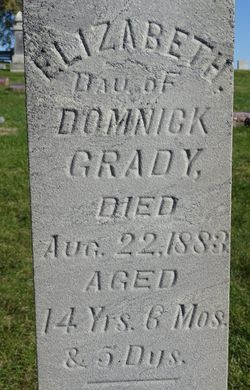
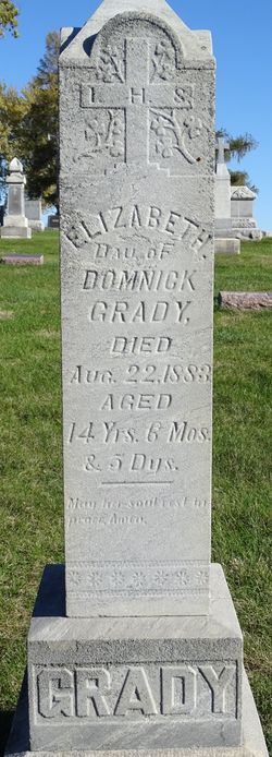
Elizabeth Grady
| Birth | : | 17 Feb 1869 Finch, Stormont, Dundas and Glengarry United Counties, Ontario, Canada |
| Death | : | 22 Aug 1883 Dunlap, Harrison County, Iowa, USA |
| Burial | : | Ford Park Cemetery, Plymouth, Plymouth Unitary Authority, England |
| Coordinate | : | 50.3813700, -4.1446090 |
| Plot | : | Block 17, Row 5 |
| Description | : | Daug of Domenic Age 14y 6m 5d |
frequently asked questions (FAQ):
-
Where is Elizabeth Grady's memorial?
Elizabeth Grady's memorial is located at: Ford Park Cemetery, Plymouth, Plymouth Unitary Authority, England.
-
When did Elizabeth Grady death?
Elizabeth Grady death on 22 Aug 1883 in Dunlap, Harrison County, Iowa, USA
-
Where are the coordinates of the Elizabeth Grady's memorial?
Latitude: 50.3813700
Longitude: -4.1446090
Family Members:
Parent
Siblings

Flowers:


Nearby Cemetories:
1. Ford Park Cemetery
Plymouth, Plymouth Unitary Authority, England
Coordinate: 50.3813700, -4.1446090
2. Gifford Place Jewish Cemetery
Plymouth, Plymouth Unitary Authority, England
Coordinate: 50.3841970, -4.1408370
3. Ebenezer Methodist Chapel Burial Grounds
Plymouth, Plymouth Unitary Authority, England
Coordinate: 50.3732824, -4.1391355
4. St Peter and The Holy Apostles Churchyard
Plymouth, Plymouth Unitary Authority, England
Coordinate: 50.3731580, -4.1544280
5. St Andrew Churchyard (Defunct)
Plymouth, Plymouth Unitary Authority, England
Coordinate: 50.3699100, -4.1399240
6. Milehouse Cemetery
Devonport, Plymouth Unitary Authority, England
Coordinate: 50.3814650, -4.1636975
7. St. Andrew with St. Luke Churchyard
Devonport, Plymouth Unitary Authority, England
Coordinate: 50.3747560, -4.1625170
8. Plymouth Hoe Old Jews Burial Ground
Plymouth, Plymouth Unitary Authority, England
Coordinate: 50.3667290, -4.1365800
9. Plymouth Naval Memorial
Plymouth, Plymouth Unitary Authority, England
Coordinate: 50.3655739, -4.1422210
10. St. Pancras Church Cemetery
Pennycross, Plymouth Unitary Authority, England
Coordinate: 50.4004000, -4.1497900
11. St. Pancras Churchyard
Pennycross, Plymouth Unitary Authority, England
Coordinate: 50.4012300, -4.1510700
12. Weston Mill Cemetery and Crematorium
Plymouth, Plymouth Unitary Authority, England
Coordinate: 50.3954330, -4.1719780
13. Efford Cemetery and Crematorium
Plymouth, Plymouth Unitary Authority, England
Coordinate: 50.3908900, -4.1100080
14. St. Edward's Churchyard
Eggbuckland, Plymouth Unitary Authority, England
Coordinate: 50.4007100, -4.1146830
15. Oreston Methodist Church Burial Ground
Oreston, Plymouth Unitary Authority, England
Coordinate: 50.3608000, -4.1080700
16. St John's Cemetery
Hooe, Plymouth Unitary Authority, England
Coordinate: 50.3540100, -4.1157900
17. Howard Road Dissenters Cemetery
Plymstock, Plymouth Unitary Authority, England
Coordinate: 50.3654900, -4.0963000
18. St Budoc Churchyard
St Budeaux, Plymouth Unitary Authority, England
Coordinate: 50.4130353, -4.1769516
19. Estover
Estover, Plymouth Unitary Authority, England
Coordinate: 50.4100000, -4.1000000
20. Maker Churchyard
Maker, Cornwall Unitary Authority, England
Coordinate: 50.3472048, -4.1853155
21. St Mary and All Saints Churchyard
Plymstock, Plymouth Unitary Authority, England
Coordinate: 50.3582720, -4.0859640
22. St Mary's Church
Tamerton Foliot, Plymouth Unitary Authority, England
Coordinate: 50.4279200, -4.1582500
23. Drake Memorial Park
Plympton, Plymouth Unitary Authority, England
Coordinate: 50.3752530, -4.0686940
24. Horson Cemetery
Antony, Cornwall Unitary Authority, England
Coordinate: 50.3744400, -4.2283200