
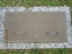
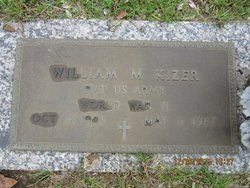
Elizabeth Hall Kizer
| Birth | : | 19 Feb 1917 Orangeburg County, South Carolina, USA |
| Death | : | 9 Aug 2002 Orangeburg, Orangeburg County, South Carolina, USA |
| Burial | : | Grove Cemetery, Grove, Vale of White Horse District, England |
| Coordinate | : | 51.6160002, -1.4299708 |
| Description | : | Elizabeth Hall Kizer — Orangeburg T&D, AUGUST 10, 2002 Elizabeth Hall Kizer, 85, of 1038 Adden Street, Orangeburg, died Friday, Aug. 9, 2002, at the Orangeburg Nursing Home. The funeral will be at 4 p.m. Sunday, Aug. 11, at Thompson Funeral Home Chapel in Orangeburg, with Rev. David Porter and Mr. George LaFrance officiating. Burial will be in Crestlawn Memorial Gardens in Orangeburg. Pallbearers will be J. P. Robinson, Charles Livingston, Ronnie Jones, Ricky Jones, Michael Jones, Steve LaFrance and Randy Robinson. Mrs. Kizer was born Feb.19, 1917, in Orangeburg County, a daughter of the late Charlie Hall and the Rachel Robinson Hall. She was... Read More |
frequently asked questions (FAQ):
-
Where is Elizabeth Hall Kizer's memorial?
Elizabeth Hall Kizer's memorial is located at: Grove Cemetery, Grove, Vale of White Horse District, England.
-
When did Elizabeth Hall Kizer death?
Elizabeth Hall Kizer death on 9 Aug 2002 in Orangeburg, Orangeburg County, South Carolina, USA
-
Where are the coordinates of the Elizabeth Hall Kizer's memorial?
Latitude: 51.6160002
Longitude: -1.4299708
Family Members:
Parent
Spouse
Siblings

Flowers:


Nearby Cemetories:
1. Grove Cemetery
Grove, Vale of White Horse District, England
Coordinate: 51.6160002, -1.4299708
2. St. John the Baptist Churchyard
Grove, Vale of White Horse District, England
Coordinate: 51.6112858, -1.4204966
3. Strict Baptist Chapel
Grove, Vale of White Horse District, England
Coordinate: 51.6051668, -1.4219236
4. St. James The Great Churchyard
Denchworth, Vale of White Horse District, England
Coordinate: 51.6229400, -1.4507800
5. St. James The Great Churchyard
West Hanney, Vale of White Horse District, England
Coordinate: 51.6325030, -1.4144360
6. Wantage Baptist Church
Wantage, Vale of White Horse District, England
Coordinate: 51.5892190, -1.4270540
7. St. Peter and Paul Churchyard
Wantage, Vale of White Horse District, England
Coordinate: 51.5886860, -1.4284970
8. St. Nicholas Churchyard
East Challow, Vale of White Horse District, England
Coordinate: 51.5919480, -1.4518960
9. St Mary's Churchyard
Lyford, Vale of White Horse District, England
Coordinate: 51.6456433, -1.4371256
10. Vicarage Hill Cemetery
East Challow, Vale of White Horse District, England
Coordinate: 51.5877810, -1.4512553
11. Chain Hill Cemetery
Wantage, Vale of White Horse District, England
Coordinate: 51.5843868, -1.4217107
12. St. Peter Churchyard
Charney Bassett, Vale of White Horse District, England
Coordinate: 51.6472944, -1.4501905
13. St. Laurence Churchyard
West Challow, Vale of White Horse District, England
Coordinate: 51.5920920, -1.4708930
14. All Saints Churchyard
Goosey, Vale of White Horse District, England
Coordinate: 51.6225320, -1.4865200
15. East Lockinge All Souls Church Cemetery
Lockinge, Vale of White Horse District, England
Coordinate: 51.5846900, -1.3899900
16. Holy Trinity Churchyard
Ardington, Vale of White Horse District, England
Coordinate: 51.5920530, -1.3784550
17. East Lockinge War Memorial
Wantage, Vale of White Horse District, England
Coordinate: 51.5844426, -1.3883416
18. St. Andrew Churchyard
Letcombe Regis, Vale of White Horse District, England
Coordinate: 51.5758900, -1.4527800
19. St. Mary's Churchyard
Childrey, Vale of White Horse District, England
Coordinate: 51.5876500, -1.4818600
20. All Saints Churchyard
Wantage, Vale of White Horse District, England
Coordinate: 51.5827496, -1.3822236
21. South Oxfordshire Memorial Park and Crematorium
Garford, Vale of White Horse District, England
Coordinate: 51.6535980, -1.3767840
22. Holy Trinity Churchyard
West Hendred, Vale of White Horse District, England
Coordinate: 51.5916030, -1.3556760
23. St Deny's Churchyard
Stanford-in-the-Vale, Vale of White Horse District, England
Coordinate: 51.6399960, -1.5062800
24. Holy Cross Churchyard
Sparsholt, Vale of White Horse District, England
Coordinate: 51.5857220, -1.5008460