

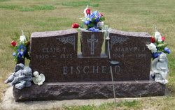
Elizabeth Theresa “Elsie” Brincks Eischeid
| Birth | : | 8 Mar 1930 Carroll, Carroll County, Iowa, USA |
| Death | : | 3 Mar 1975 Carroll, Carroll County, Iowa, USA |
| Burial | : | St Helen Churchyard, Thorganby, Selby District, England |
| Coordinate | : | 53.8666100, -0.9530300 |
| Description | : | Elizabeth "Elsie" was the daughter of Joseph Brincks and Kathryn Hoffman. She married Marvin Joseph Eischeid, son of Albert Peter Eischeid and Frances Truhe, May 3, 1949, in Willey, Carroll Co., Iowa. |
frequently asked questions (FAQ):
-
Where is Elizabeth Theresa “Elsie” Brincks Eischeid's memorial?
Elizabeth Theresa “Elsie” Brincks Eischeid's memorial is located at: St Helen Churchyard, Thorganby, Selby District, England.
-
When did Elizabeth Theresa “Elsie” Brincks Eischeid death?
Elizabeth Theresa “Elsie” Brincks Eischeid death on 3 Mar 1975 in Carroll, Carroll County, Iowa, USA
-
Where are the coordinates of the Elizabeth Theresa “Elsie” Brincks Eischeid's memorial?
Latitude: 53.8666100
Longitude: -0.9530300
Family Members:
Parent

Spouse
Siblings
Children
Flowers:


Nearby Cemetories:
1. St Helen Churchyard
Thorganby, Selby District, England
Coordinate: 53.8666100, -0.9530300
2. Quaker Cemetery
East Cottingwith, East Riding of Yorkshire Unitary Authority, England
Coordinate: 53.8746050, -0.9327040
3. St Mary Churchyard
East Cottingwith, East Riding of Yorkshire Unitary Authority, England
Coordinate: 53.8738030, -0.9317490
4. St Mary and St Lawrence Churchyard
Ellerton, East Riding of Yorkshire Unitary Authority, England
Coordinate: 53.8499000, -0.9347520
5. All Saints Churchyard
Aughton, East Riding of Yorkshire Unitary Authority, England
Coordinate: 53.8393490, -0.9352200
6. St Helen Churchyard
Wheldrake, York Unitary Authority, England
Coordinate: 53.8965340, -0.9626520
7. St. Helen's Churchyard
Skipwith, Selby District, England
Coordinate: 53.8386300, -1.0022900
8. All Saints Churchyard
Bubwith, East Riding of Yorkshire Unitary Authority, England
Coordinate: 53.8170680, -0.9200130
9. Holy Trinity Churchyard
Elvington, York Unitary Authority, England
Coordinate: 53.9186950, -0.9341610
10. St. Helen's Churchyard
Escrick, Selby District, England
Coordinate: 53.8805200, -1.0460990
11. St. Mary's Churchyard
Riccall, Selby District, England
Coordinate: 53.8330620, -1.0601630
12. St Paul Churchyard
Kexby, York Unitary Authority, England
Coordinate: 53.9505970, -0.9339900
13. All Saints Churchyard
Barlby, Selby District, England
Coordinate: 53.7987840, -1.0415840
14. St Helen Churchyard
Stillingfleet, Selby District, England
Coordinate: 53.8618710, -1.0994760
15. St Matthew Churchyard
Naburn, York Unitary Authority, England
Coordinate: 53.9009520, -1.0899200
16. Fulford Cemetery
Fulford, York Unitary Authority, England
Coordinate: 53.9304450, -1.0683670
17. Holy Trinity Churchyard
Acaster Malbis, York Unitary Authority, England
Coordinate: 53.9052480, -1.0975170
18. St Paul Churchyard
Heslington, York Unitary Authority, England
Coordinate: 53.9471780, -1.0445150
19. St. Andrew's Old Churchyard
Bishopthorpe, York Unitary Authority, England
Coordinate: 53.9221490, -1.0929640
20. St Mary the Virgin Churchyard
Hemingbrough, Selby District, England
Coordinate: 53.7672100, -0.9796300
21. St Botolph Churchyard
Allerthorpe, East Riding of Yorkshire Unitary Authority, England
Coordinate: 53.9171530, -0.8052080
22. St Nicholas Churchyard
Dunnington, York Unitary Authority, England
Coordinate: 53.9661680, -0.9829590
23. St Andrew Churchyard
Bishopthorpe, York Unitary Authority, England
Coordinate: 53.9236690, -1.0955320
24. St Catherine Churchyard
Barmby Moor, East Riding of Yorkshire Unitary Authority, England
Coordinate: 53.9307670, -0.8189520