

Ella C. Lewis Potter
| Birth | : | May 1864 Vermont, USA |
| Death | : | 1925 |
| Burial | : | Bethel Baptist Church Cemetery, Marion, McDowell County, USA |
| Coordinate | : | 35.5847890, -81.9929230 |
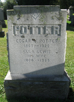
| Inscription | : | ELLA LEWIS His Wife 1864 - 1925 |
| Description | : | Daughter of William Lewis and Martha Barber. . Wife of Edgar Webster Potter, whom she married on Oct. 7, 1885, in Poultney, Rutland, VT. . |
frequently asked questions (FAQ):
-
Where is Ella C. Lewis Potter's memorial?
Ella C. Lewis Potter's memorial is located at: Bethel Baptist Church Cemetery, Marion, McDowell County, USA.
-
When did Ella C. Lewis Potter death?
Ella C. Lewis Potter death on 1925 in
-
Where are the coordinates of the Ella C. Lewis Potter's memorial?
Latitude: 35.5847890
Longitude: -81.9929230
Family Members:
Spouse
Flowers:


Nearby Cemetories:
1. Bethel Baptist Church Cemetery
Marion, McDowell County, USA
Coordinate: 35.5847890, -81.9929230
2. Nealsville Church Of God Cemetery
McDowell County, USA
Coordinate: 35.5885590, -81.9924240
3. Glenwood Independent Baptist Church Cemetery
McDowell County, USA
Coordinate: 35.5884730, -81.9829800
4. Mountain Creek Independent Baptist Church Cemetery
Glenwood, McDowell County, USA
Coordinate: 35.5657700, -82.0057900
5. Arrowood Cemetery
Glenwood, McDowell County, USA
Coordinate: 35.5774970, -81.9669530
6. Neal Cemetery
McDowell County, USA
Coordinate: 35.6068993, -81.9991989
7. Lawing Cemetery
McDowell County, USA
Coordinate: 35.5628014, -82.0056000
8. Sugar Hill Baptist Church Cemetery
McDowell County, USA
Coordinate: 35.5803070, -82.0316050
9. Glenwood Cemetery
Marion, McDowell County, USA
Coordinate: 35.6117870, -81.9708270
10. Pleasant Grove Cemetery
Marion, McDowell County, USA
Coordinate: 35.5830920, -82.0399750
11. Mount Pleasant Baptist Church Cemetery
Marion, McDowell County, USA
Coordinate: 35.6174650, -82.0190030
12. Freedom Missionary Baptist Church Cemetery
McDowell County, USA
Coordinate: 35.5835400, -82.0412400
13. Macedonia Baptist Church Cemetery
McDowell County, USA
Coordinate: 35.5770190, -81.9369820
14. Ridgeway Freewill Baptist Church Cemetery
McDowell County, USA
Coordinate: 35.6319070, -82.0010530
15. Old Pleasant Grove Methodist Church Cemetery
McDowell County, USA
Coordinate: 35.5785060, -82.0515210
16. Sprouse Cemetery
Dysartsville, McDowell County, USA
Coordinate: 35.5723570, -81.9297430
17. Haney Cemetery
McDowell County, USA
Coordinate: 35.6293983, -81.9400024
18. Gardin-Haney Cemetery
McDowell County, USA
Coordinate: 35.6303270, -81.9400350
19. Poteet Family Cemetery
McDowell County, USA
Coordinate: 35.5774040, -81.9125020
20. Brackettown Cemetery
McDowell County, USA
Coordinate: 35.5532990, -81.9207993
21. Old Thermal City Church Cemetery
Thermal City, Rutherford County, USA
Coordinate: 35.5173120, -81.9706250
22. Providence United Methodist Church Cemetery
Marion, McDowell County, USA
Coordinate: 35.6368860, -82.0503680
23. Barnes Cemetery
McDowell County, USA
Coordinate: 35.6567440, -81.9692870
24. Epps Family Cemetery
McDowell County, USA
Coordinate: 35.5778020, -81.9016850