


Ella C Mueller Lubbers
| Birth | : | 27 Dec 1894 |
| Death | : | 22 Nov 1986 |
| Burial | : | St Johns Roman Catholic Church Cemetery, Poulton-le-Fylde, Wyre Borough, England |
| Coordinate | : | 53.8520854, -2.9873511 |
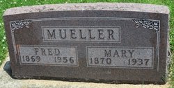
| Description | : | Mrs. ENNO (Ella C. Mueller) LUBBERS Funeral services for Ella C. Lubbers were held Tuesday, Nov. 25, 11 a.m. at St. Paul Lutheran Church, Postville. The Rev. Julius L. Peterson officiated. The Schutte Funeral Service, Postville, was in charge of arrangements. Interment was in the Postville Cemetery. Ella C. Lubbers, daughter of Fred and Mary (Radloff) Mueller, was born Dec. 27, 1894 in Read Township, Clayton County, Iowa. She died Nov. 22, 1986 at the Good Samaritan Center, Postville. She was baptized Feb. 15, 1895 by Rev. Seifert and confirmed Feb. 24, 1907 by Rev. Linnenbuerger. She attended rural Clayton... Read More |
frequently asked questions (FAQ):
-
Where is Ella C Mueller Lubbers's memorial?
Ella C Mueller Lubbers's memorial is located at: St Johns Roman Catholic Church Cemetery, Poulton-le-Fylde, Wyre Borough, England.
-
When did Ella C Mueller Lubbers death?
Ella C Mueller Lubbers death on 22 Nov 1986 in
-
Where are the coordinates of the Ella C Mueller Lubbers's memorial?
Latitude: 53.8520854
Longitude: -2.9873511
Family Members:
Parent

Spouse
Siblings
Children

Flowers:


Nearby Cemetories:
1. St Johns Roman Catholic Church Cemetery
Poulton-le-Fylde, Wyre Borough, England
Coordinate: 53.8520854, -2.9873511
2. Saint Chad Churchyard
Poulton-le-Fylde, Wyre Borough, England
Coordinate: 53.8471992, -2.9925005
3. Poulton-Le-Fylde Old Cemetery
Poulton-le-Fylde, Wyre Borough, England
Coordinate: 53.8458145, -2.9713324
4. Poulton New Cemetery
Poulton-le-Fylde, Wyre Borough, England
Coordinate: 53.8461240, -2.9689560
5. Blackpool Cemetery and Crematorium
Poulton-le-Fylde, Wyre Borough, England
Coordinate: 53.8465680, -3.0196600
6. All Hallow's Churchyard
Bispham, Blackpool Unitary Authority, England
Coordinate: 53.8567580, -3.0372160
7. Christ Church Thornton Churchyard
Thornton-Cleveleys, Wyre Borough, England
Coordinate: 53.8772800, -3.0221100
8. St. Anne's Churchyard
Blackburn, Blackburn with Darwen Unitary Authority, England
Coordinate: 53.8381160, -2.9362870
9. St Anne Churchyard
Singleton, Fylde Borough, England
Coordinate: 53.8379280, -2.9359890
10. Blackpool Jewish Cemetery
Blackpool, Blackpool Unitary Authority, England
Coordinate: 53.8287397, -3.0311753
11. Layton Cemetery
Blackpool, Blackpool Unitary Authority, England
Coordinate: 53.8273740, -3.0328240
12. St Stephen On-the-Cliffs Churchyard
Blackpool, Blackpool Unitary Authority, England
Coordinate: 53.8407230, -3.0515610
13. St Paul's Church & Medical Centre
Blackpool Unitary Authority, England
Coordinate: 53.8291540, -3.0533490
14. St John the Evangelist Churchyard
Blackpool, Blackpool Unitary Authority, England
Coordinate: 53.8182303, -3.0508197
15. Marton Burial Ground
Great Marton, Blackpool Unitary Authority, England
Coordinate: 53.8030870, -3.0108350
16. Carlton Cemetery& Crematorium
Blackpool, Blackpool Unitary Authority, England
Coordinate: 53.8095921, -3.0364920
17. Saint Paul Churchyard
Great Marton, Blackpool Unitary Authority, England
Coordinate: 53.8053220, -3.0268330
18. St James Churchyard
Stalmine, Wyre Borough, England
Coordinate: 53.9020510, -2.9533720
19. Preesall Cemetery
Preesall, Wyre Borough, England
Coordinate: 53.9075410, -2.9635410
20. St. John’s Churchyard
Out Rawcliffe, Wyre Borough, England
Coordinate: 53.8741650, -2.8959310
21. St Michael Churchyard
Weeton, Fylde Borough, England
Coordinate: 53.7995380, -2.9358020
22. St Anne Churchyard
Great Eccleston, Wyre Borough, England
Coordinate: 53.8481413, -2.8835925
23. Elswick Congregational Chapelyard
Elswick, Fylde Borough, England
Coordinate: 53.8378950, -2.8775320
24. Holy Trinity Churchyard
Blackpool, Blackpool Unitary Authority, England
Coordinate: 53.7962949, -3.0536214