
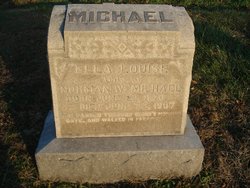
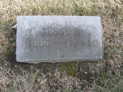
Ella Louise Greer Michael
| Birth | : | 22 Jun 1870 Longwood, Pettis County, Missouri, USA |
| Death | : | 22 Jun 1907 Pettis County, Missouri, USA |
| Burial | : | Longwood Cemetery, Longwood, Pettis County, USA |
| Coordinate | : | 38.8973800, -93.1683400 |
| Inscription | : | Wife of Norman W. |
| Description | : | Living in Longwood Township at the time of her death. Married Norman Ward Michael 24 January 1906, Pettis County, Missouri. |
frequently asked questions (FAQ):
-
Where is Ella Louise Greer Michael's memorial?
Ella Louise Greer Michael's memorial is located at: Longwood Cemetery, Longwood, Pettis County, USA.
-
When did Ella Louise Greer Michael death?
Ella Louise Greer Michael death on 22 Jun 1907 in Pettis County, Missouri, USA
-
Where are the coordinates of the Ella Louise Greer Michael's memorial?
Latitude: 38.8973800
Longitude: -93.1683400
Family Members:
Parent
Siblings

Children
Flowers:


Nearby Cemetories:
1. Longwood Cemetery
Longwood, Pettis County, USA
Coordinate: 38.8973800, -93.1683400
2. Hieronymus Family Cemetery
Longwood, Pettis County, USA
Coordinate: 38.8835890, -93.1375330
3. Jenkins Cemetery
Pettis County, USA
Coordinate: 38.8879050, -93.1270310
4. Cunningham Cemetery
Saline County, USA
Coordinate: 38.9356003, -93.1643982
5. Raines Cemetery
Heath Creek Township, Pettis County, USA
Coordinate: 38.9269600, -93.1227000
6. Millers Chapel Cemetery
Heath Creek Township, Pettis County, USA
Coordinate: 38.8951700, -93.1088600
7. Hunt Cemetery
Saline County, USA
Coordinate: 38.9470190, -93.1429480
8. Bethlehem Cemetery
Marshall Junction, Saline County, USA
Coordinate: 38.9369011, -93.2172012
9. Clopton Cemetery
Pettis County, USA
Coordinate: 38.8436012, -93.1286011
10. Ellis Cemetery
Newland, Pettis County, USA
Coordinate: 38.8366400, -93.1410500
11. Witcher Family Cemetery
Marshall Junction, Saline County, USA
Coordinate: 38.9553000, -93.2103000
12. Scott Cemetery
Pettis County, USA
Coordinate: 38.8293991, -93.1367035
13. High Hill Cemetery
Pettis County, USA
Coordinate: 38.8544006, -93.2446976
14. Clark Cemetery
Marshall, Saline County, USA
Coordinate: 38.9716590, -93.1876550
15. Heath Creek Cemetery
Blackwater Township, Saline County, USA
Coordinate: 38.9458535, -93.0921440
16. High Point Cemetery
Hughesville, Pettis County, USA
Coordinate: 38.8549995, -93.2506027
17. Union Cemetery
Heath Creek Township, Pettis County, USA
Coordinate: 38.8586900, -93.0721900
18. Hopewell Cemetery
Newland, Pettis County, USA
Coordinate: 38.8130989, -93.1660995
19. Lockney Cemetery
Marshall, Saline County, USA
Coordinate: 38.9834667, -93.2174667
20. Berea Church Cemetery
Cooper County, USA
Coordinate: 38.9020200, -93.0408200
21. Forbes-Heard Cemetery
Hughesville, Pettis County, USA
Coordinate: 38.7937100, -93.2470200
22. Finley Farm Cemetery
Nelson, Saline County, USA
Coordinate: 38.9960980, -93.0789210
23. Olive Branch Cemetery
Beaman, Pettis County, USA
Coordinate: 38.7792015, -93.1355972
24. Blue Lick Cemetery
Blue Lick, Saline County, USA
Coordinate: 39.0143220, -93.2142900