

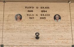
Ellen Georgia “Ella” Wegner Halm Gorecki Kraus
| Birth | : | 25 Jun 1913 Greeley County, Nebraska, USA |
| Death | : | 27 Jan 2005 Pleasanton, Alameda County, California, USA |
| Burial | : | Chapel of the Chimes Memorial Park, Hayward, Alameda County, USA |
| Coordinate | : | 37.6110992, -122.0222015 |
| Description | : | 1st married Melvin Edward Halm 1932 Ne. 2nd married Joseph Mark Gorecki 1962 Ca. 3rd married Floyd Danler Kraus 1970 Nv. [Transfer Management][Edit][Delete] Birth: Jun. 25, 1913 Nebraska, USA Death: Jan. 27, 2005 [Edit Dates] ELLA G. KRAUS Passed away January 27, 2005, after suffering a stroke. Born in Nebraska on June 25, 1913. She lived in Hayward, California, for 60 years, moving to Pleasanton to live with her family for the last 9 years. She had been retired for 35 years. She lived her 91 years to the fullest, with a zest for life. She is survived by her family who cherished and loved her. Her daughter, Esther... Read More |
frequently asked questions (FAQ):
-
Where is Ellen Georgia “Ella” Wegner Halm Gorecki Kraus's memorial?
Ellen Georgia “Ella” Wegner Halm Gorecki Kraus's memorial is located at: Chapel of the Chimes Memorial Park, Hayward, Alameda County, USA.
-
When did Ellen Georgia “Ella” Wegner Halm Gorecki Kraus death?
Ellen Georgia “Ella” Wegner Halm Gorecki Kraus death on 27 Jan 2005 in Pleasanton, Alameda County, California, USA
-
Where are the coordinates of the Ellen Georgia “Ella” Wegner Halm Gorecki Kraus's memorial?
Latitude: 37.6110992
Longitude: -122.0222015
Family Members:
Parent

Spouse

Siblings
Flowers:


Nearby Cemetories:
1. Chapel of the Chimes Memorial Park
Hayward, Alameda County, USA
Coordinate: 37.6110992, -122.0222015
2. Garin Regional Park
Hayward, Alameda County, USA
Coordinate: 37.6365760, -122.0338690
3. Holy Sepulchre Cemetery
Hayward, Alameda County, USA
Coordinate: 37.6486588, -122.0647125
4. Centerville Pioneer Cemetery
Fremont, Alameda County, USA
Coordinate: 37.5596504, -122.0080643
5. Saint James Episcopal Church Columbarium
Fremont, Alameda County, USA
Coordinate: 37.5514440, -122.0171910
6. Holy Cross Orthodox Monastery Burial Site
Castro Valley, Alameda County, USA
Coordinate: 37.6331890, -121.9511560
7. Lone Tree Cemetery
Hayward, Alameda County, USA
Coordinate: 37.6747017, -122.0483017
8. Holy Ghost Cemetery
Fremont, Alameda County, USA
Coordinate: 37.5410995, -122.0132980
9. Mount Saint Joseph Cemetery
Hayward, Alameda County, USA
Coordinate: 37.6685028, -122.0760422
10. Mount Eden Cemetery
Hayward, Alameda County, USA
Coordinate: 37.6384000, -122.1105800
11. Irvington Memorial Cemetery
Fremont, Alameda County, USA
Coordinate: 37.5325012, -121.9653015
12. Ohlone Indians Cemetery
Fremont, Alameda County, USA
Coordinate: 37.5317001, -121.9344025
13. Dublin Cemetery
Dublin, Alameda County, USA
Coordinate: 37.6996040, -121.9384384
14. Mission San Jose Cemetery
Fremont, Alameda County, USA
Coordinate: 37.5338287, -121.9200745
15. Dominican Sisters of Mission San Jose Cemetery
Fremont, Alameda County, USA
Coordinate: 37.5342751, -121.9184265
16. San Lorenzo Pioneer Memorial Park
San Lorenzo, Alameda County, USA
Coordinate: 37.6901500, -122.1288500
17. Pleasanton Memorial Gardens Cemetery
Pleasanton, Alameda County, USA
Coordinate: 37.6466179, -121.8812256
18. Saint Augustines Cemetery
Pleasanton, Alameda County, USA
Coordinate: 37.6476250, -121.8811340
19. Saint Josephs Cemetery
Fremont, Alameda County, USA
Coordinate: 37.5172005, -121.9175034
20. County Cemetery
San Leandro, Alameda County, USA
Coordinate: 37.7165794, -122.1227798
21. Mount Calvary Cemetery
San Leandro, Alameda County, USA
Coordinate: 37.7178001, -122.1228027
22. Cedar Lawn Memorial Park
Fremont, Alameda County, USA
Coordinate: 37.4646988, -121.9131012
23. Saint Patricks Seminary Chapel Crypt
Menlo Park, San Mateo County, USA
Coordinate: 37.4595050, -122.1680330
24. First United Methodist Church Memorial Garden
Palo Alto, Santa Clara County, USA
Coordinate: 37.4493870, -122.1568630