
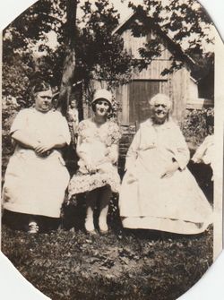
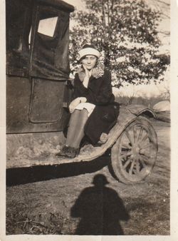
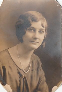

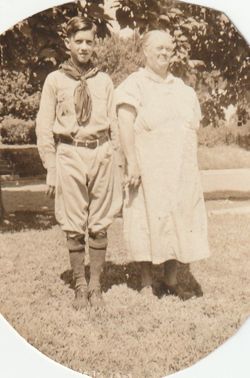
Ellen Rosetta “Ella” Rath Stewart
| Birth | : | 4 Jul 1909 Oskaloosa, Jefferson County, Kansas, USA |
| Death | : | 24 Oct 1979 Lawrence, Douglas County, Kansas, USA |
| Burial | : | Memorial Park Cemetery, Lawrence, Douglas County, USA |
| Coordinate | : | 38.9552994, -95.2153015 |
| Plot | : | Section: Garden of Devotion; Acacia D and E |
| Description | : | Services for Mrs. Ellen Rossetta Stewart, 70, 1104 Conn., will be at 10 a.m. Saturday at the Rumsey Funeral Home. Willis Cheatham will officiate. Burial will be in Memorial Park Cemetery. Mrs. Stewart died Wednesday, in Lawrence Memorial Hospital. She was born July 4, 1909, in Oskaloosa and came to Lawrence from Topeka in 1941. She was a member of the Southside Church of Christ. Survivors include her husband, Leland L. Stewart, of the home; three sons, Donald, Rt. 2, Leland, 1113 Pa., and Lester, 907 Ward; a brother Glen W. Rath, Oskaloosa; three... Read More |
frequently asked questions (FAQ):
-
Where is Ellen Rosetta “Ella” Rath Stewart's memorial?
Ellen Rosetta “Ella” Rath Stewart's memorial is located at: Memorial Park Cemetery, Lawrence, Douglas County, USA.
-
When did Ellen Rosetta “Ella” Rath Stewart death?
Ellen Rosetta “Ella” Rath Stewart death on 24 Oct 1979 in Lawrence, Douglas County, Kansas, USA
-
Where are the coordinates of the Ellen Rosetta “Ella” Rath Stewart's memorial?
Latitude: 38.9552994
Longitude: -95.2153015
Family Members:
Parent

Spouse
Siblings
Children
Flowers:


Nearby Cemetories:
1. Memorial Park Cemetery
Lawrence, Douglas County, USA
Coordinate: 38.9552994, -95.2153015
2. Mount Calvary Catholic Cemetery
Lawrence, Douglas County, USA
Coordinate: 38.9580002, -95.2139969
3. Oak Hill Cemetery
Lawrence, Douglas County, USA
Coordinate: 38.9589005, -95.2118988
4. Trinity Episcopal Church Columbarium
Lawrence, Douglas County, USA
Coordinate: 38.9653893, -95.2373886
5. Saint Johns Catholic Cemetery
Douglas County, USA
Coordinate: 38.9437900, -95.1919600
6. Dyche Hall Natural History Museum
Lawrence, Douglas County, USA
Coordinate: 38.9584800, -95.2434800
7. Haskell Cemetery
Lawrence, Douglas County, USA
Coordinate: 38.9353790, -95.2284241
8. Franklin Cemetery
Douglas County, USA
Coordinate: 38.9437523, -95.1869431
9. Pioneer Cemetery
Lawrence, Douglas County, USA
Coordinate: 38.9528008, -95.2611008
10. First Presbyterian Church Memorial Garden
Lawrence, Douglas County, USA
Coordinate: 38.9414900, -95.2641600
11. County Poor Farm Cemetery
Douglas County, USA
Coordinate: 38.9119400, -95.2214600
12. Kennedy Cemetery
Douglas County, USA
Coordinate: 38.9112900, -95.2269200
13. Maple Grove Cemetery
Lawrence, Douglas County, USA
Coordinate: 39.0018997, -95.2316971
14. Adams Cemetery
Douglas County, USA
Coordinate: 38.9955400, -95.2509100
15. Blue Mound Cemetery
Lawrence, Douglas County, USA
Coordinate: 38.9046600, -95.1865400
16. Davis Cemetery
Lawrence, Douglas County, USA
Coordinate: 38.9722500, -95.2831100
17. Marshall Cemetery
Douglas County, USA
Coordinate: 38.9040800, -95.2446700
18. Dutton Cemetery
Douglas County, USA
Coordinate: 38.8989800, -95.2790600
19. Luckan Family Cemetery
Fall Leaf, Leavenworth County, USA
Coordinate: 38.9808500, -95.1128000
20. Corpus Christi Catholic Church Columbarium
Lawrence, Douglas County, USA
Coordinate: 38.9572250, -95.3238450
21. Cemetery Beni Israel
Eudora, Douglas County, USA
Coordinate: 38.9280128, -95.1122208
22. Lyon Family Cemetery
Lawrence, Douglas County, USA
Coordinate: 38.9877440, -95.3166530
23. Richland Cemetery
Lawrence, Douglas County, USA
Coordinate: 38.8768997, -95.2630997
24. Southwest City Cemetery
Eudora, Douglas County, USA
Coordinate: 38.9334800, -95.1070300