
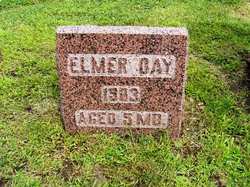
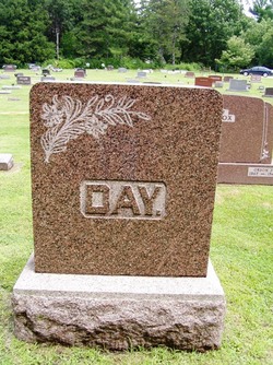
Elmer Day
| Birth | : | 8 Apr 1903 Boone County, Iowa, USA |
| Death | : | Aug 1903 Boone County, Iowa, USA |
| Burial | : | Graceland Memorial Gardens, Milford, Clermont County, USA |
| Coordinate | : | 39.1963997, -84.1999969 |
| Description | : | The 5 months old child of Mr. and Mrs. Ed Day, residing eight miles east of the city, died on Tuesday of cholera infamtum. The funeral was held Wednesday afternoon at 3:00 o'clock from the family residence, Rev. Crawford officiating, and interment in the Mitchell cemetery |
frequently asked questions (FAQ):
-
Where is Elmer Day's memorial?
Elmer Day's memorial is located at: Graceland Memorial Gardens, Milford, Clermont County, USA.
-
When did Elmer Day death?
Elmer Day death on Aug 1903 in Boone County, Iowa, USA
-
Where are the coordinates of the Elmer Day's memorial?
Latitude: 39.1963997
Longitude: -84.1999969
Family Members:
Parent

Siblings

Flowers:


Nearby Cemetories:
1. Graceland Memorial Gardens
Milford, Clermont County, USA
Coordinate: 39.1963997, -84.1999969
2. Myers Cemetery
Goshen, Clermont County, USA
Coordinate: 39.2236900, -84.1836300
3. Mount Zion Cemetery
Craver, Clermont County, USA
Coordinate: 39.1613464, -84.1940231
4. Mulberry Cemetery
Milford, Clermont County, USA
Coordinate: 39.1947784, -84.2469864
5. Hill Family Cemetery
Stonelick, Clermont County, USA
Coordinate: 39.1622490, -84.1826090
6. Union Cemetery
Branch Hill, Clermont County, USA
Coordinate: 39.2152850, -84.2409180
7. Irwin Cemetery
Goshen, Clermont County, USA
Coordinate: 39.2176850, -84.1543670
8. Simpkins Family Cemetery
Williams Corners, Clermont County, USA
Coordinate: 39.1733900, -84.1532700
9. Goshen Cemetery
Goshen, Clermont County, USA
Coordinate: 39.2377300, -84.1579100
10. Olive Cemetery
Stonelick Township, Clermont County, USA
Coordinate: 39.1563988, -84.1552963
11. Brown Family Cemetery
Top-of-the-Ridge, Clermont County, USA
Coordinate: 39.1968980, -84.2695320
12. Ranson Family Cemetery
Top-of-the-Ridge, Clermont County, USA
Coordinate: 39.2077220, -84.2719890
13. Concord Methodist Episcopal Cemetery
Sundale, Clermont County, USA
Coordinate: 39.2318820, -84.2599380
14. Jewish Cemeteries of Greater Cincinnati – Loveland
Loveland, Clermont County, USA
Coordinate: 39.2281970, -84.2641830
15. Stouder Cemetery
Goshen Township, Clermont County, USA
Coordinate: 39.2312700, -84.1335700
16. Greenlawn Cemetery
Milford, Clermont County, USA
Coordinate: 39.1706009, -84.2758026
17. Rapp Cemetery
Belfast, Clermont County, USA
Coordinate: 39.1434900, -84.1529200
18. Perintown United Methodist Church Cemetery
Perintown, Clermont County, USA
Coordinate: 39.1374512, -84.2339783
19. Plainview Cemetery
Newtonsville, Clermont County, USA
Coordinate: 39.1796989, -84.1177979
20. Prickett Cemetery
Newtonsville, Clermont County, USA
Coordinate: 39.1756700, -84.1188800
21. Paxton Cemetery
Loveland, Clermont County, USA
Coordinate: 39.2549000, -84.2433500
22. Shumard Cemetery
Stonelick, Clermont County, USA
Coordinate: 39.1685000, -84.1202500
23. Waldschmidt Cemetery
Camp Dennison, Hamilton County, USA
Coordinate: 39.1944900, -84.2882200
24. Saint Philomena Church Cemetery
Stonelick Township, Clermont County, USA
Coordinate: 39.1277618, -84.1848450