


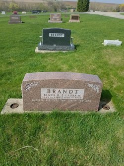
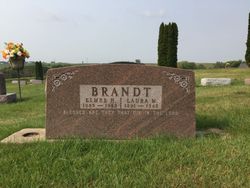
Elmer Henry Brandt
| Birth | : | 5 Nov 1889 Garnavillo, Clayton County, Iowa, USA |
| Death | : | 29 May 1983 Marion, Linn County, Iowa, USA |
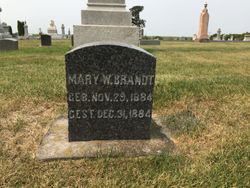
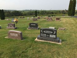
| Burial | : | Garnavillo Community Cemetery, Garnavillo, Clayton County, USA |
| Coordinate | : | 42.8656000, -91.2422100 |
| Plot | : | Bl 11 Lt 5 Gr 3 |
| Description | : | From the History of Clayton Co., Iowa From The Earliest Historical Times Down to the Present-Vol.II-Pg.56-57- Author: Realto E. Price Elmer H. Brandt has given distinctive evidence of his progressiveness and good judgment in connection with the ownership and operation of one of the fine farms of his native county, for the major part of the splendid improvements on the place has been made by him and the pervasive atmosphere of thrift and prosperity marks the owner as a man of energy and enterprise. Mr. Brandt was born in Garnavillo township, this county, on the 5th of November, 1890, and is a... Read More |
frequently asked questions (FAQ):
-
Where is Elmer Henry Brandt's memorial?
Elmer Henry Brandt's memorial is located at: Garnavillo Community Cemetery, Garnavillo, Clayton County, USA.
-
When did Elmer Henry Brandt death?
Elmer Henry Brandt death on 29 May 1983 in Marion, Linn County, Iowa, USA
-
Where are the coordinates of the Elmer Henry Brandt's memorial?
Latitude: 42.8656000
Longitude: -91.2422100
Family Members:
Parent
Spouse
Siblings

Children
Flowers:


Nearby Cemetories:
1. Garnavillo Community Cemetery
Garnavillo, Clayton County, USA
Coordinate: 42.8656000, -91.2422100
2. Garnavillo Cemetery
Garnavillo, Clayton County, USA
Coordinate: 42.8660300, -91.2390100
3. Saint Joseph Cemetery
Garnavillo, Clayton County, USA
Coordinate: 42.8628006, -91.2502975
4. McClelland Cemetery
Garnavillo, Clayton County, USA
Coordinate: 42.8249879, -91.2084641
5. Pioneer Rock Cemetery
Ceres, Clayton County, USA
Coordinate: 42.8230591, -91.1863937
6. Clayton Center Cemetery
Clayton Center, Clayton County, USA
Coordinate: 42.8841705, -91.3225021
7. Zion Lutheran Cemetery
Clayton Center, Clayton County, USA
Coordinate: 42.8841705, -91.3249969
8. Clayton Cemetery
Clayton, Clayton County, USA
Coordinate: 42.9043999, -91.1641998
9. Tangeman Family Cemetery
Garnavillo, Clayton County, USA
Coordinate: 42.8580000, -91.1420000
10. Saint Michael Cemetery
Clayton County, USA
Coordinate: 42.8055992, -91.1802979
11. County Home Cemetery
Clayton Center, Clayton County, USA
Coordinate: 42.8916702, -91.3499985
12. Krumm Cemetery
Garber, Clayton County, USA
Coordinate: 42.7913760, -91.3023559
13. Colony Catholic Cemetery (Defunct)
Read Township, Clayton County, USA
Coordinate: 42.8830000, -91.3580000
14. Borcherding Cemetery
Jefferson Township, Clayton County, USA
Coordinate: 42.8182983, -91.1414032
15. National Cemetery
National, Clayton County, USA
Coordinate: 42.9536018, -91.2902985
16. Storck Cemetery
Guttenberg, Clayton County, USA
Coordinate: 42.7694335, -91.1834638
17. Harford Cemetery
Wyalusing, Grant County, USA
Coordinate: 42.9401000, -91.1401800
18. Saint Paula Cemetery
Osterdock, Clayton County, USA
Coordinate: 42.7635994, -91.1992035
19. Meenan Cemetery
Communia, Clayton County, USA
Coordinate: 42.7999862, -91.3584693
20. Norwegian Church Cemetery
McGregor, Clayton County, USA
Coordinate: 42.9644400, -91.1764100
21. Old Garber Cemetery
Garber, Clayton County, USA
Coordinate: 42.7560005, -91.2580032
22. Elkader Cemetery
Elkader, Clayton County, USA
Coordinate: 42.8541718, -91.4000015
23. Bagley Cemetery
Bagley, Grant County, USA
Coordinate: 42.9019012, -91.0907974
24. First Evangelical Lutheran Church Cemetery
McGregor, Clayton County, USA
Coordinate: 42.9718000, -91.1760000