
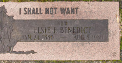
Elsie F. Twining Benedict
| Birth | : | 24 Jan 1880 Creighton, Knox County, Nebraska, USA |
| Death | : | 8 Aug 1980 Kent, King County, Washington, USA |
| Burial | : | Whitstable Cemetery, Whitstable, City of Canterbury, England |
| Coordinate | : | 51.3529870, 1.0338530 |
frequently asked questions (FAQ):
-
Where is Elsie F. Twining Benedict's memorial?
Elsie F. Twining Benedict's memorial is located at: Whitstable Cemetery, Whitstable, City of Canterbury, England.
-
When did Elsie F. Twining Benedict death?
Elsie F. Twining Benedict death on 8 Aug 1980 in Kent, King County, Washington, USA
-
Where are the coordinates of the Elsie F. Twining Benedict's memorial?
Latitude: 51.3529870
Longitude: 1.0338530
Family Members:
Parent
Spouse
Siblings

Children
Flowers:


Nearby Cemetories:
1. All Saints Churchyard
Whitstable, City of Canterbury, England
Coordinate: 51.3558090, 1.0396670
2. St Alphege Churchyard
Whitstable, City of Canterbury, England
Coordinate: 51.3576330, 1.0251080
3. St. Alphege's Churchyard
Seasalter, City of Canterbury, England
Coordinate: 51.3432041, 1.0041740
4. St John the Baptist Churchyard
Swalecliffe, City of Canterbury, England
Coordinate: 51.3645500, 1.0667200
5. St Cosmus and St Damian Churchyard
Blean, City of Canterbury, England
Coordinate: 51.3052720, 1.0530480
6. Herne Bay Cemetery
Herne Bay, City of Canterbury, England
Coordinate: 51.3571810, 1.1304820
7. All Saints Churchyard
Graveney, Swale Borough, England
Coordinate: 51.3261450, 0.9447880
8. St Martins
Herne, City of Canterbury, England
Coordinate: 51.3500600, 1.1333200
9. St Martin's Churchyard
Herne, City of Canterbury, England
Coordinate: 51.3497060, 1.1334370
10. St Michael Churchyard
Hernhill, Swale Borough, England
Coordinate: 51.3077430, 0.9612050
11. Canterbury City Cemetery
Canterbury, City of Canterbury, England
Coordinate: 51.2843285, 1.0637640
12. St Nicholas Hospital Church
Harbledown, City of Canterbury, England
Coordinate: 51.2828200, 1.0536580
13. Christ Church Churchyard
Dunkirk, Swale Borough, England
Coordinate: 51.2916540, 0.9741890
14. St Michael and All Angels Church
Harbledown, City of Canterbury, England
Coordinate: 51.2824590, 1.0556800
15. Canterbury Jewish Cemetery
Canterbury, City of Canterbury, England
Coordinate: 51.2846135, 1.0706660
16. St. Dunstan Churchyard
Canterbury, City of Canterbury, England
Coordinate: 51.2836820, 1.0707800
17. St Bartholomew Churchyard
Goodnestone, Dover District, England
Coordinate: 51.3166220, 0.9322200
18. Sturry Cemetery
Sturry, City of Canterbury, England
Coordinate: 51.3058100, 1.1277700
19. St. John the Baptist Hospital Chapelyard
Canterbury, City of Canterbury, England
Coordinate: 51.2832713, 1.0837677
20. Holy Cross Church
Canterbury, City of Canterbury, England
Coordinate: 51.2811350, 1.0755710
21. St Nicholas Churchyard
Sturry, City of Canterbury, England
Coordinate: 51.2984830, 1.1201330
22. Westgate Gardens
Canterbury, City of Canterbury, England
Coordinate: 51.2805250, 1.0745040
23. St Gregory's Priory (defunct)
Canterbury, City of Canterbury, England
Coordinate: 51.2831127, 1.0855358
24. St Peter the Apostle Churchyard
Canterbury, City of Canterbury, England
Coordinate: 51.2807260, 1.0775370