
| Birth | : | 15 Jan 1912 Council Grove, Morris County, Kansas, USA |
| Death | : | 2 Feb 1995 Council Grove, Morris County, Kansas, USA |
| Burial | : | Norwich Village Cemetery, Norwich, Oxford County Municipality, Canada |
| Coordinate | : | 42.9840000, -80.6041800 |
| Plot | : | Kieffer |
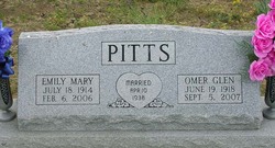
| Description | : | Elven Edgar Kieffer Lifelong Resident Elven Edgar Kieffer, 83, who died Thursday, February 2, 1995, at the Morris County Hospital, was a lifelong resident of the community. He was born January 15, 1912, near Council Grove, son of Vincent and Lucy Belle Leffler Kieffer. He lived all his life in the neighborhood where he was born. Services were this morning at 10:00 o'clock at the Kendall Funeral Chapel, with burial in the Greenwood Cemetery. He lay in state at the Chapel from noon until 9:00 p.m. Sunday, and family and friends met there from 7:00 until 8:00. |
frequently asked questions (FAQ):
-
Where is Elven Kieffer's memorial?
Elven Kieffer's memorial is located at: Norwich Village Cemetery, Norwich, Oxford County Municipality, Canada.
-
When did Elven Kieffer death?
Elven Kieffer death on 2 Feb 1995 in Council Grove, Morris County, Kansas, USA
-
Where are the coordinates of the Elven Kieffer's memorial?
Latitude: 42.9840000
Longitude: -80.6041800
Family Members:
Parent

Spouse
Siblings
Children
Flowers:


Nearby Cemetories:
1. Norwich Village Cemetery
Norwich, Oxford County Municipality, Canada
Coordinate: 42.9840000, -80.6041800
2. North Norwich Pioneer Cemetery
Norwich, Oxford County Municipality, Canada
Coordinate: 43.0016975, -80.6069489
3. Quaker Street Friends Cemetery
Norwich, Oxford County Municipality, Canada
Coordinate: 43.0001900, -80.6155300
4. Norwich Gore Cemetery
Norwich, Oxford County Municipality, Canada
Coordinate: 42.9999400, -80.5564000
5. Milldale Burial Grounds
Milldale, Oxford County Municipality, Canada
Coordinate: 42.9452515, -80.5852966
6. African Methodist Episcopal Cemetery
Otterville, Oxford County Municipality, Canada
Coordinate: 42.9313940, -80.6082310
7. St. John's Anglican Cemetery
Oxford County Municipality, Canada
Coordinate: 42.9290830, -80.6072860
8. Otterville Cemetery
Otterville, Oxford County Municipality, Canada
Coordinate: 42.9285800, -80.6073870
9. Burgessville Baptist Cemetery
Burgessville, Oxford County Municipality, Canada
Coordinate: 43.0223500, -80.6601600
10. Pine Street Burying Ground
Otterville, Oxford County Municipality, Canada
Coordinate: 42.9235458, -80.6128235
11. Newark District Community Cemetery
Newark, Oxford County Municipality, Canada
Coordinate: 42.9701580, -80.6853440
12. Erbtown Cemetery
Otterville, Oxford County Municipality, Canada
Coordinate: 42.9232445, -80.6193924
13. New Durham Cemetery
Oxford County Municipality, Canada
Coordinate: 43.0418091, -80.5674210
14. Springford Community Cemetery
Springford, Oxford County Municipality, Canada
Coordinate: 42.9207090, -80.6433210
15. Hatchley Cemetery
Hatchley, Brant County Municipality, Canada
Coordinate: 43.0247000, -80.5253000
16. Summerville Cemetery
Oxford County Municipality, Canada
Coordinate: 42.9071410, -80.5751040
17. St. Peter's Roman Cathlolic Cemetery
Norwich, Oxford County Municipality, Canada
Coordinate: 42.9566270, -80.7072350
18. Bookton Cemetery
Bookton, Norfolk County, Canada
Coordinate: 42.9458700, -80.5059800
19. White Cemetery
Harley, Brant County Municipality, Canada
Coordinate: 43.0494000, -80.5377000
20. Zion Oriel Cemetery
Oriel, Oxford County Municipality, Canada
Coordinate: 43.0650630, -80.6425670
21. Northfield Cemetery
Northfield, Brant County Municipality, Canada
Coordinate: 43.0303600, -80.4847900
22. Kelvin United Cemetery
Kelvin, Norfolk County, Canada
Coordinate: 42.9974900, -80.4591900
23. Hill Free Methodist Cemetery
Burford, Brant County Municipality, Canada
Coordinate: 43.0044851, -80.4600627
24. Kelvin Cemetery
Burford, Brant County Municipality, Canada
Coordinate: 43.0005280, -80.4587240