
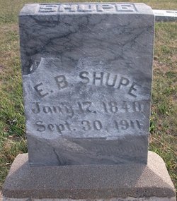
Emanuel Blanchard Shupe
| Birth | : | 17 Jan 1840 Lima, Allen County, Ohio, USA |
| Death | : | 30 Sep 1911 Harper, Harper County, Kansas, USA |
| Burial | : | Halcumb Cemetery, Montgomery Creek, Shasta County, USA |
| Coordinate | : | 40.8213997, -121.9308014 |
| Description | : | He married Margaret S. Hall on Feb. 16, 1862 then on July 09, 1871 he married Anna Good. Emanuel's parents were Jacob J. Shupe and Cynthia Ann Myers. |
frequently asked questions (FAQ):
-
Where is Emanuel Blanchard Shupe's memorial?
Emanuel Blanchard Shupe's memorial is located at: Halcumb Cemetery, Montgomery Creek, Shasta County, USA.
-
When did Emanuel Blanchard Shupe death?
Emanuel Blanchard Shupe death on 30 Sep 1911 in Harper, Harper County, Kansas, USA
-
Where are the coordinates of the Emanuel Blanchard Shupe's memorial?
Latitude: 40.8213997
Longitude: -121.9308014
Family Members:
Parent
Spouse
Siblings
Children

Flowers:


Nearby Cemetories:
1. Halcumb Cemetery
Montgomery Creek, Shasta County, USA
Coordinate: 40.8213997, -121.9308014
2. Cove Cemetery
Shasta County, USA
Coordinate: 40.9034100, -121.9386200
3. Fender Cemetery
Redding, Shasta County, USA
Coordinate: 40.7167320, -122.0352859
4. Oak Run Cemetery
Oak Run, Shasta County, USA
Coordinate: 40.6882324, -122.0308685
5. Fern Cemetery
Shasta County, USA
Coordinate: 40.6473600, -121.8861500
6. Josephine Cemetery
Whitmore, Shasta County, USA
Coordinate: 40.6326828, -121.9151993
7. Tuttle Gulch Cemetery
Cottonwood, Shasta County, USA
Coordinate: 40.6326828, -121.9151993
8. Goose Valley Indian Burial Grounds
Burney, Shasta County, USA
Coordinate: 40.9503800, -121.7459000
9. Whitmore Evangelical Cemetery
Shasta County, USA
Coordinate: 40.6235580, -121.8566580
10. Snooks Cemetery
Burney, Shasta County, USA
Coordinate: 40.8788900, -121.6649800
11. Big Bend Indian Cemetery
Big Bend, Shasta County, USA
Coordinate: 41.0345700, -121.9298500
12. Burney Cemetery
Burney, Shasta County, USA
Coordinate: 40.8837100, -121.6566600
13. Burney District Cemetery
Burney, Shasta County, USA
Coordinate: 40.8801600, -121.6526200
14. Hunt Cemetery
Shasta County, USA
Coordinate: 40.6236200, -122.1116300
15. Burney Falls Cemetery
Burney, Shasta County, USA
Coordinate: 41.0228400, -121.6456300
16. Stillwater Indian Cemetery
Shasta County, USA
Coordinate: 40.7340500, -122.3170800
17. Cayton Cemetery
Cayton, Shasta County, USA
Coordinate: 41.0319700, -121.6320800
18. Ogburn Inwood Cemetery
Shingletown, Shasta County, USA
Coordinate: 40.5092100, -121.9622000
19. Millville IOOF Cemetery
Millville, Shasta County, USA
Coordinate: 40.5539017, -122.1663971
20. Houston Cemetery
Redding, Shasta County, USA
Coordinate: 40.6533012, -122.2940979
21. Mountain Home Cemetery
Shasta County, USA
Coordinate: 40.5342700, -121.7218200
22. Millville Masonic Cemetery
Millville, Shasta County, USA
Coordinate: 40.5555000, -122.1842804
23. Beck Cemetery
Shasta County, USA
Coordinate: 40.5487400, -122.1720900
24. Original Plateau Cemetery
Shasta County, USA
Coordinate: 40.5020100, -121.8248200