
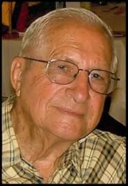

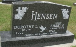
Emery Edward “Hank” Hensen
| Birth | : | 12 Dec 1922 Bouton, Dallas County, Iowa, USA |
| Death | : | 30 Jun 2018 Perry, Dallas County, Iowa, USA |
| Burial | : | Great Harwood Cemetery, Great Harwood, Hyndburn Borough, England |
| Coordinate | : | 53.7796190, -2.4091680 |
| Inscription | : | parents of Sharon & Shirley, U S Navy WWII |
| Description | : | Emery “Hank” Hensen, age 95 of Perry, passed away on Saturday, June 30, 2018 at the Perry Lutheran Home in Perry, Iowa. Funeral service will be held on Friday, July 6, 2018 at 10:30 a.m. at the Perry Bible Church in Perry. Visitation will be on Thursday, July 5, 2018 from 2-7 p.m. with family present from 5-7 p.m. at the Carris Family Funeral Home & Cremation Care in Perry. Burial will be in the Woodward Cemetery at Woodward Iowa with military honors. Memorials will be given to his family and may be left at the Carris Family Funeral Home... Read More |
frequently asked questions (FAQ):
-
Where is Emery Edward “Hank” Hensen's memorial?
Emery Edward “Hank” Hensen's memorial is located at: Great Harwood Cemetery, Great Harwood, Hyndburn Borough, England.
-
When did Emery Edward “Hank” Hensen death?
Emery Edward “Hank” Hensen death on 30 Jun 2018 in Perry, Dallas County, Iowa, USA
-
Where are the coordinates of the Emery Edward “Hank” Hensen's memorial?
Latitude: 53.7796190
Longitude: -2.4091680
Family Members:
Parent

Spouse
Siblings
Flowers:


Nearby Cemetories:
1. Great Harwood Cemetery
Great Harwood, Hyndburn Borough, England
Coordinate: 53.7796190, -2.4091680
2. Our Lady and Saint Hubert
Great Harwood, Hyndburn Borough, England
Coordinate: 53.7851070, -2.4009760
3. St. Bartholomew's Churchyard
Great Harwood, Hyndburn Borough, England
Coordinate: 53.7900670, -2.4055460
4. All Saints Churchyard
Clayton-le-Moors, Hyndburn Borough, England
Coordinate: 53.7738520, -2.3881690
5. Barnes Square Weslyan Methodist Churchyard
Clayton-le-Moors, Hyndburn Borough, England
Coordinate: 53.7744350, -2.3853800
6. St Marys Burial Ground
Clayton-le-Moors, Hyndburn Borough, England
Coordinate: 53.7792778, -2.3705871
7. Church and Clayton-le-Moors Cemetery
Accrington, Hyndburn Borough, England
Coordinate: 53.7630200, -2.3804820
8. St James Churchyard
Church, Hyndburn Borough, England
Coordinate: 53.7574640, -2.3942660
9. St. James' Parish Church
Accrington, Hyndburn Borough, England
Coordinate: 53.7519900, -2.3652600
10. Accrington Cemetery and Crematorium
Accrington, Hyndburn Borough, England
Coordinate: 53.7623787, -2.3508649
11. St James Church
Altham, Hyndburn Borough, England
Coordinate: 53.7928940, -2.3465250
12. Blackburn Cemetery
Blackburn, Blackburn with Darwen Unitary Authority, England
Coordinate: 53.7662430, -2.4726050
13. Saint Mary and All Saints Churchyard
Whalley, Ribble Valley Borough, England
Coordinate: 53.8211890, -2.4078080
14. New Lane Baptist Chapel Chapelyard
Oswaldwistle, Hyndburn Borough, England
Coordinate: 53.7381100, -2.4049500
15. St. John's Churchyard
Read, Ribble Valley Borough, England
Coordinate: 53.8088800, -2.3585600
16. Christ Church Churchyard
Accrington, Hyndburn Borough, England
Coordinate: 53.7478560, -2.3605820
17. Immanuel Churchyard
Oswaldwistle, Hyndburn Borough, England
Coordinate: 53.7358300, -2.4056200
18. St Peter Churchyard
Salesbury, Ribble Valley Borough, England
Coordinate: 53.7915000, -2.4859100
19. St. Leonard Old Churchyard
Langho, Ribble Valley Borough, England
Coordinate: 53.8178590, -2.4552870
20. St Alban's Churchyard
Blackburn, Blackburn with Darwen Unitary Authority, England
Coordinate: 53.7530090, -2.4748540
21. Brockhall Hospital Cemetery
Brockhall Village, Ribble Valley Borough, England
Coordinate: 53.8186850, -2.4560220
22. Holy Trinity Church
Blackburn with Darwen Unitary Authority, England
Coordinate: 53.7511727, -2.4747178
23. Whalley, Wiswell and Barrow Cemetery
Whalley, Ribble Valley Borough, England
Coordinate: 53.8308490, -2.4057280
24. Mount St Presbyterian Chapelyard
Blackburn, Blackburn with Darwen Unitary Authority, England
Coordinate: 53.7478000, -2.4775000