
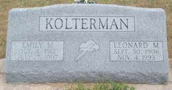
Emily M Huelle Kolterman
| Birth | : | 4 Oct 1912 Vassar, Osage County, Kansas, USA |
| Death | : | 7 Jun 1997 Pierce, Pierce County, Nebraska, USA |
| Burial | : | St Peter and St Paul Churchyard, Exton, Rutland Unitary Authority, England |
| Coordinate | : | 52.6905790, -0.6396910 |
frequently asked questions (FAQ):
-
Where is Emily M Huelle Kolterman's memorial?
Emily M Huelle Kolterman's memorial is located at: St Peter and St Paul Churchyard, Exton, Rutland Unitary Authority, England.
-
When did Emily M Huelle Kolterman death?
Emily M Huelle Kolterman death on 7 Jun 1997 in Pierce, Pierce County, Nebraska, USA
-
Where are the coordinates of the Emily M Huelle Kolterman's memorial?
Latitude: 52.6905790
Longitude: -0.6396910
Family Members:
Parent

Spouse

Siblings
Children
Flowers:


Nearby Cemetories:
1. St Peter and St Paul Churchyard
Exton, Rutland Unitary Authority, England
Coordinate: 52.6905790, -0.6396910
2. St. Nicholas Churchyard
Cottesmore, Rutland Unitary Authority, England
Coordinate: 52.7128800, -0.6655820
3. St Mary the Virgin Churchyard
Greetham, Rutland Unitary Authority, England
Coordinate: 52.7216100, -0.6325650
4. Empingham Whitwell Road Cemetery
Empingham, Rutland Unitary Authority, England
Coordinate: 52.6676155, -0.6029043
5. St Peter Churchyard
Empingham, Rutland Unitary Authority, England
Coordinate: 52.6656310, -0.5957880
6. St Andrew Churchyard
Hambleton, Rutland Unitary Authority, England
Coordinate: 52.6585060, -0.6712280
7. St Mary the Virgin Churchyard
Edith Weston, Rutland Unitary Authority, England
Coordinate: 52.6379100, -0.6311100
8. St Mary the Virgin Churchyard
Ashwell, Rutland Unitary Authority, England
Coordinate: 52.7144490, -0.7200580
9. Oakham Cemetery
Oakham, Rutland Unitary Authority, England
Coordinate: 52.6768700, -0.7297400
10. Saint Peter and Saint Paul's Churchyard
Market Overton, Rutland Unitary Authority, England
Coordinate: 52.7385000, -0.6893000
11. St Nicholas Churchyard
Thistleton, Rutland Unitary Authority, England
Coordinate: 52.7516900, -0.6483100
12. St Peter's Churchyard
Tickencote, Rutland Unitary Authority, England
Coordinate: 52.6741278, -0.5365826
13. Holy Trinity Churchyard
Teigh, Rutland Unitary Authority, England
Coordinate: 52.7348560, -0.7207040
14. SS Peter and Paul Church
Langham, Rutland Unitary Authority, England
Coordinate: 52.6918700, -0.7529300
15. St. John The Baptist Church
North Luffenham, Rutland Unitary Authority, England
Coordinate: 52.6186570, -0.6211140
16. St Nicholas Churchyard
Pilton, Rutland Unitary Authority, England
Coordinate: 52.6165200, -0.6504100
17. St Peter & St Paul Churchyard
Great Casterton, Rutland Unitary Authority, England
Coordinate: 52.6676700, -0.5203600
18. St. Peter and St. Paul's Churchyard
Wing, Rutland Unitary Authority, England
Coordinate: 52.6172140, -0.6814150
19. Saint Michael and All Angels Churchyard
Edmondthorpe, Melton Borough, England
Coordinate: 52.7488800, -0.7301600
20. Edmondthorpe Main Street Cemetery
Edmondthorpe, Melton Borough, England
Coordinate: 52.7491560, -0.7300030
21. Ketton Park Burial Ground
Ketton, Rutland Unitary Authority, England
Coordinate: 52.6240570, -0.5604330
22. Ketton St Mary the Virgin Churchyard
Ketton, Rutland Unitary Authority, England
Coordinate: 52.6274671, -0.5509559
23. St Andrew Churchyard
Whissendine, Rutland Unitary Authority, England
Coordinate: 52.7200520, -0.7682370
24. St Mary the Virgin Churchyard
South Luffenham, Rutland Unitary Authority, England
Coordinate: 52.6067200, -0.6114100