
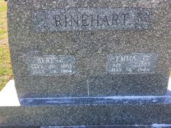
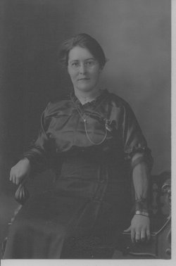
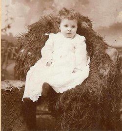
Emma Catherine Bond Rinehart
| Birth | : | 3 Apr 1885 Glasco, Cloud County, Kansas, USA |
| Death | : | 4 May 1944 Glasco, Cloud County, Kansas, USA |
| Burial | : | Glasco Cemetery, Glasco, Cloud County, USA |
| Coordinate | : | 39.3574000, -97.8265000 |
| Plot | : | 4GE7 |
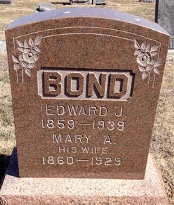
| Description | : | Glasco Sun, May 11, 1944: Emma Catherine Bond, the eldest daughter of Edward and Mary Bond, was born April 3, 1885, at Glasco, Kansas, and departed this life on May 4, 1944, at the age of 59 years, one month, and one day, at the home north of Glasco. She had spent all her life in the Glasco community, except for five years when they lived at Concordia, and later at Norway, Kansas. She was baptized and confirmed in St. Paul's Lutheran Church at an early age. On July 28, 1907, she was united in marriage to Bert Edward Rinehart. To this union... Read More |
frequently asked questions (FAQ):
-
Where is Emma Catherine Bond Rinehart's memorial?
Emma Catherine Bond Rinehart's memorial is located at: Glasco Cemetery, Glasco, Cloud County, USA.
-
When did Emma Catherine Bond Rinehart death?
Emma Catherine Bond Rinehart death on 4 May 1944 in Glasco, Cloud County, Kansas, USA
-
Where are the coordinates of the Emma Catherine Bond Rinehart's memorial?
Latitude: 39.3574000
Longitude: -97.8265000
Family Members:
Parent
Spouse

Siblings
Flowers:


Nearby Cemetories:
1. Glasco Cemetery
Glasco, Cloud County, USA
Coordinate: 39.3574000, -97.8265000
2. Saint Marys Catholic Cemetery
Glasco, Cloud County, USA
Coordinate: 39.3574000, -97.8245000
3. Simpson Cemetery
Simpson, Mitchell County, USA
Coordinate: 39.3633003, -97.9471970
4. Bethel Cemetery
Meredith Township, Cloud County, USA
Coordinate: 39.3506000, -97.7029000
5. Delphos Cemetery
Delphos, Ottawa County, USA
Coordinate: 39.2778015, -97.7416992
6. Saint Paul Cemetery
Delphos, Ottawa County, USA
Coordinate: 39.2677994, -97.7518997
7. Asherville Cemetery
Asherville, Mitchell County, USA
Coordinate: 39.4205000, -97.9672900
8. Morrison Cemetery
Center Township, Cloud County, USA
Coordinate: 39.4817009, -97.7975006
9. Summit Cemetery
Jamestown, Cloud County, USA
Coordinate: 39.4813200, -97.8628800
10. Green Mound Cemetery
Asherville, Mitchell County, USA
Coordinate: 39.3203011, -97.9858017
11. Coursen Grove Cemetery
Simpson, Mitchell County, USA
Coordinate: 39.3060989, -97.9792023
12. Hall Cemetery
Cloud County, USA
Coordinate: 39.4455986, -97.7033005
13. Saint Peters Cemetery
Miltonvale, Cloud County, USA
Coordinate: 39.3652350, -97.6483570
14. Bell-Bogardus Cemetery
Asherville, Mitchell County, USA
Coordinate: 39.4242410, -97.9919970
15. Bohemian National Cemetery
Ada, Ottawa County, USA
Coordinate: 39.2193870, -97.9054030
16. Wilcox Cemetery
Cloud County, USA
Coordinate: 39.4925003, -97.7313995
17. West Asher Cemetery
Scottsville, Mitchell County, USA
Coordinate: 39.4815000, -97.9661600
18. Baldwin Cemetery
Ottawa County, USA
Coordinate: 39.2061005, -97.9111023
19. Kindel Cemetery
Center Township, Cloud County, USA
Coordinate: 39.4519005, -97.6464005
20. Smith Cemetery
Asherville, Mitchell County, USA
Coordinate: 39.4516690, -98.0098850
21. McBride Cemetery
Beloit, Mitchell County, USA
Coordinate: 39.4808006, -97.9907990
22. Enterprise Cemetery
Cloud County, USA
Coordinate: 39.4230995, -97.6106033
23. Shiloh Cemetery
Beloit, Mitchell County, USA
Coordinate: 39.3574982, -98.0594025
24. Summit Cemetery #3
Macyville, Cloud County, USA
Coordinate: 39.5258330, -97.9194440