
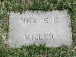
Emma Ettilla Crabb Miller
| Birth | : | 9 Apr 1858 Rochester, Olmsted County, Minnesota, USA |
| Death | : | 22 Jun 1919 Chelan, Chelan County, Washington, USA |
| Burial | : | Chelan Fraternal Cemetery, Chelan, Chelan County, USA |
| Coordinate | : | 47.8502998, -120.0081024 |
| Plot | : | South Fraternal Row21 BLK22 LN2 |
| Description | : | m: William Childs Miller Emma E. Crabb was borne at Rochester, Minn., April 9, 1858, and was raised and educated at that place. On Jan 21st, 1882, she was untied in marriage with W. C. Miller of Minneapolis, where she and her husband started their new home. To this union were born eight children, four boys and four girls. Three of the boys and one girl have preceded her to the "Other Life." About five years ago she had a very severe attack of Typus Malaria from which she never regained her former heath and strength. Three years ago she was attacked... Read More |
frequently asked questions (FAQ):
-
Where is Emma Ettilla Crabb Miller's memorial?
Emma Ettilla Crabb Miller's memorial is located at: Chelan Fraternal Cemetery, Chelan, Chelan County, USA.
-
When did Emma Ettilla Crabb Miller death?
Emma Ettilla Crabb Miller death on 22 Jun 1919 in Chelan, Chelan County, Washington, USA
-
Where are the coordinates of the Emma Ettilla Crabb Miller's memorial?
Latitude: 47.8502998
Longitude: -120.0081024
Family Members:
Children

Flowers:


Nearby Cemetories:
1. Chelan Fraternal Cemetery
Chelan, Chelan County, USA
Coordinate: 47.8502998, -120.0081024
2. Mount Olivet Cemetery
Chelan, Chelan County, USA
Coordinate: 47.8451000, -119.9946000
3. Saint Andrews Episcopal Church
Chelan, Chelan County, USA
Coordinate: 47.8397460, -120.0183780
4. Riverview Cemetery
Chelan, Chelan County, USA
Coordinate: 47.8335991, -119.9944000
5. Manson Indian Cemetery
Manson, Chelan County, USA
Coordinate: 47.8800000, -120.1300000
6. Ballard Family Cemetery
Stayman, Chelan County, USA
Coordinate: 47.7811100, -120.1133300
7. Fletcher Cemetery
Douglas County, USA
Coordinate: 47.7430992, -119.9403000
8. Brays Landing Cemetery
Douglas County, USA
Coordinate: 47.7364120, -120.1704660
9. Kummer Cemetery
Waterville, Douglas County, USA
Coordinate: 47.6559000, -120.0332000
10. Packwood Memorial Cemetery
Dyer, Douglas County, USA
Coordinate: 48.0118305, -119.8178880
11. Dick Family Cemetery
Okanogan County, USA
Coordinate: 48.0502700, -119.9241700
12. Miller Family Cemetery
Okanogan County, USA
Coordinate: 48.0530300, -119.9288000
13. Pateros Cemetery
Pateros, Okanogan County, USA
Coordinate: 48.0516600, -119.9097300
14. Waterville Cemetery
Waterville, Douglas County, USA
Coordinate: 47.6418500, -120.0685940
15. Gate of Heaven Catholic Cemetery
Waterville, Douglas County, USA
Coordinate: 47.6382100, -120.0671690
16. Douglas Lutheran Cemetery
Douglas County, USA
Coordinate: 47.6189003, -119.9614029
17. Badger Mountain View Cemetery
Douglas County, USA
Coordinate: 47.6088000, -120.0476000
18. Mansfield Cemetery
Mansfield, Douglas County, USA
Coordinate: 47.8088880, -119.6508330
19. Orondo Community Cemetery
Orondo, Douglas County, USA
Coordinate: 47.6486015, -120.2136002
20. Buckingham Cemetery
Douglas County, USA
Coordinate: 47.8669014, -119.6286011
21. Happy Home Cemetery
Farmer, Douglas County, USA
Coordinate: 47.6268997, -119.8125000
22. Methow Cemetery
Methow, Okanogan County, USA
Coordinate: 48.1102982, -120.0124969
23. Entiat Cemetery
Entiat, Chelan County, USA
Coordinate: 47.6755981, -120.3043976
24. Bridgeport Cemetery
Bridgeport, Douglas County, USA
Coordinate: 48.0050000, -119.6738800