
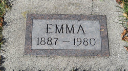
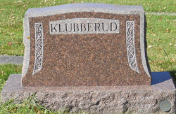
Emma Flaa Klubberud
| Birth | : | 24 Jan 1887 Richland County, North Dakota, USA |
| Death | : | 20 Jan 1980 Wilkin County, Minnesota, USA |
| Burial | : | Eminence Cemetery, Thornburg, Smith County, USA |
| Coordinate | : | 39.9432983, -98.8005981 |
frequently asked questions (FAQ):
-
Where is Emma Flaa Klubberud's memorial?
Emma Flaa Klubberud's memorial is located at: Eminence Cemetery, Thornburg, Smith County, USA.
-
When did Emma Flaa Klubberud death?
Emma Flaa Klubberud death on 20 Jan 1980 in Wilkin County, Minnesota, USA
-
Where are the coordinates of the Emma Flaa Klubberud's memorial?
Latitude: 39.9432983
Longitude: -98.8005981
Family Members:
Parent

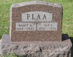
Spouse
Siblings

Children
Flowers:


Nearby Cemetories:
1. Eminence Cemetery
Thornburg, Smith County, USA
Coordinate: 39.9432983, -98.8005981
2. Reamsville Cemetery
Reamsville, Smith County, USA
Coordinate: 39.9441500, -98.8593500
3. Spring Vale Cemetery
Washington Township, Smith County, USA
Coordinate: 39.9154700, -98.7424900
4. Reamsville Methodist Church Cemetery
Reamsville, Smith County, USA
Coordinate: 39.9299500, -98.8693970
5. Womer Cemetery
Womer, Smith County, USA
Coordinate: 39.9736400, -98.7110800
6. William Nelson Gravesite
Athol, Smith County, USA
Coordinate: 39.8866080, -98.8708130
7. Pleasant Hill Cemetery
Reamsville, Smith County, USA
Coordinate: 39.9510994, -98.9175034
8. Meade Cemetery
Reamsville, Smith County, USA
Coordinate: 39.8680992, -98.8839035
9. Cedar Hill Cemetery
Cora, Smith County, USA
Coordinate: 39.8863200, -98.6550000
10. Fuller Cemetery
Riverton, Franklin County, USA
Coordinate: 40.0764000, -98.7925700
11. Zion Cemetery
Athol, Smith County, USA
Coordinate: 39.8434100, -98.9171700
12. Walnut Creek Cemetery
Inavale, Webster County, USA
Coordinate: 40.0463982, -98.6793976
13. Fairview Cemetery
Smith Center, Smith County, USA
Coordinate: 39.7966995, -98.7881012
14. Stevens Cemetery
Riverton, Franklin County, USA
Coordinate: 40.0977000, -98.8201500
15. Riverton Cemetery
Riverton, Franklin County, USA
Coordinate: 40.0970993, -98.7530975
16. Oriole Cemetery
Lebanon, Smith County, USA
Coordinate: 39.9366400, -98.5938300
17. Oak Hill Cemetery
Lebanon, Smith County, USA
Coordinate: 39.8437010, -98.6186200
18. Mount Hope Cemetery
Lebanon, Smith County, USA
Coordinate: 39.9721800, -98.5799700
19. Pleasant View Cemetery
Athol, Smith County, USA
Coordinate: 39.7859000, -98.8982000
20. Mount Pleasant Cemetery
Webster County, USA
Coordinate: 40.0491982, -98.6125031
21. Fairview Stone Cemetery
Kensington, Smith County, USA
Coordinate: 39.9304330, -99.0479270
22. Greenwood Cemetery
Franklin, Franklin County, USA
Coordinate: 40.1018982, -98.9443970
23. Pleasant Plains Cemetery
Lebanon, Smith County, USA
Coordinate: 39.8793400, -98.5419400
24. Gust Cemetery
Webster County, USA
Coordinate: 40.0172005, -98.5421982