

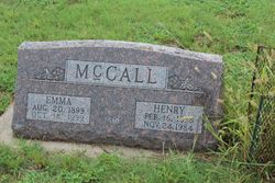
Emma Jane Vanderlip McCall
| Birth | : | 20 Aug 1899 Rooks County, Kansas, USA |
| Death | : | 14 Oct 1999 Woodston, Rooks County, Kansas, USA |
| Burial | : | Ash Rock Cemetery, Woodston, Rooks County, USA |
| Coordinate | : | 39.5248909, -99.0817719 |
| Description | : | WOODSTON — Emma Jane McCall, 100, Woodston, died Thursday, Oct. 14, 1999, at the Osborne County Memorial Hospital, Osborne. Mrs. McCall was born Emma Jane Vanderlip on Aug. 20,1899, at [Ash Rock] Township, rural Woodston, KS, Rooks County, and was a lifetime resident of the Woodston area. She was a homemaker and a member of Ash Rock Congregational Church, Ash Rock Missionary Society and Goodwill Sewing Circle, all of Woodston. She was preceded in death by her husband, Henry, in 1984; and a daughter, Mildred Anderson, in 1994. Survivors include three sons, Robert of Woodston, Donald of Phillipsburg and Walter of Aztec,... Read More |
frequently asked questions (FAQ):
-
Where is Emma Jane Vanderlip McCall's memorial?
Emma Jane Vanderlip McCall's memorial is located at: Ash Rock Cemetery, Woodston, Rooks County, USA.
-
When did Emma Jane Vanderlip McCall death?
Emma Jane Vanderlip McCall death on 14 Oct 1999 in Woodston, Rooks County, Kansas, USA
-
Where are the coordinates of the Emma Jane Vanderlip McCall's memorial?
Latitude: 39.5248909
Longitude: -99.0817719
Family Members:
Parent

Spouse
Siblings
Children
Flowers:


Nearby Cemetories:
1. Ash Rock Cemetery
Woodston, Rooks County, USA
Coordinate: 39.5248909, -99.0817719
2. Spring Branch Cemetery
Woodston, Rooks County, USA
Coordinate: 39.5099983, -99.0580978
3. Pleasant Ridge Cemetery
Kirwin, Phillips County, USA
Coordinate: 39.5963000, -99.1234000
4. Grant Center Cemetery
Alton, Osborne County, USA
Coordinate: 39.5242004, -98.9708023
5. Pleasant Valley Cemetery
Osborne County, USA
Coordinate: 39.4583015, -99.0077972
6. Woodston Cemetery
Woodston, Rooks County, USA
Coordinate: 39.4375000, -99.1268997
7. Pioneer Cemetery
Alton, Osborne County, USA
Coordinate: 39.4742012, -98.9749985
8. Bohemian Cemetery
Claudell, Smith County, USA
Coordinate: 39.6187800, -99.0428200
9. Leasburg Cemetery
Cedar, Smith County, USA
Coordinate: 39.5819016, -98.9728012
10. West Hope Cemetery
Rooks County, USA
Coordinate: 39.5024986, -99.2110977
11. Greenwood Cemetery
Kirwin, Phillips County, USA
Coordinate: 39.5931900, -99.2064600
12. Sumner Cemetery
Alton, Osborne County, USA
Coordinate: 39.4799995, -98.9338913
13. Saint Francis Catholic Cemetery
Cedar, Smith County, USA
Coordinate: 39.6328011, -98.9816971
14. Bow Creek Cemetery
Glade, Phillips County, USA
Coordinate: 39.5681000, -99.2696991
15. Survey Cemetery
Woodston, Rooks County, USA
Coordinate: 39.3722000, -99.1333008
16. Kirwin Cemetery
Kirwin, Phillips County, USA
Coordinate: 39.6781006, -99.1421967
17. Stockton Cemetery
Stockton, Rooks County, USA
Coordinate: 39.4406700, -99.2647400
18. Saint Thomas Cemetery
Stockton, Rooks County, USA
Coordinate: 39.4449997, -99.2771988
19. Mount Ayr Cemetery
Alton, Osborne County, USA
Coordinate: 39.3764000, -98.9717026
20. Butler Cemetery
Osborne County, USA
Coordinate: 39.5400009, -98.8494034
21. Old Stockton Cemetery
Stockton, Rooks County, USA
Coordinate: 39.4597015, -99.3050003
22. Cedar Cemetery
Cedar, Smith County, USA
Coordinate: 39.6685982, -98.9310989
23. Bigge Family Cemetery
Stockton, Rooks County, USA
Coordinate: 39.4584700, -99.3053200
24. Pleasant Plain Cemetery
Osborne County, USA
Coordinate: 39.3367004, -99.0372009