
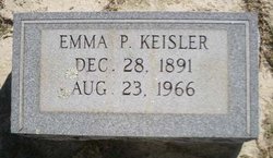
Emma Pearl Long Keisler
| Birth | : | 28 Dec 1891 Hollow Creek, Lexington County, South Carolina, USA |
| Death | : | 23 Aug 1966 Columbia, Richland County, South Carolina, USA |
| Burial | : | Prospect Hill Cemetery, Omaha, Douglas County, USA |
| Coordinate | : | 41.2780991, -95.9593964 |
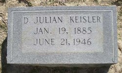
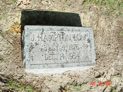
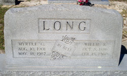
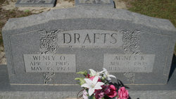
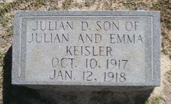
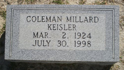
| Description | : | Gilbert - Mrs. Emma Long Keisler, 74, fo RFD 1 Gilbert, died Tuesday at Columbia Hospital. She was born in the Hollow Creek section of Lexington County, daughter of the late Wiley and Tarcy Price Long. She was a member of St. Paul Lutheran Church and was the widow of Julian D. Keisler. Surviving are four daughters, Mrs. W. O. (Agnes) Drafts, Mrs. Herman (Dorothy) Koon, of Gilbert, Mrs. T. A. (Elease) Sease of West Columbia and Mrs. Floyd (Louise) Bundrick of Mountville, and a son, Coleman Keisler of Gilbert. Funeral services will be at 4 p.m. Wednesday at St.... Read More |
frequently asked questions (FAQ):
-
Where is Emma Pearl Long Keisler's memorial?
Emma Pearl Long Keisler's memorial is located at: Prospect Hill Cemetery, Omaha, Douglas County, USA.
-
When did Emma Pearl Long Keisler death?
Emma Pearl Long Keisler death on 23 Aug 1966 in Columbia, Richland County, South Carolina, USA
-
Where are the coordinates of the Emma Pearl Long Keisler's memorial?
Latitude: 41.2780991
Longitude: -95.9593964
Family Members:
Parent
Spouse
Siblings
Children
Flowers:


Nearby Cemetories:
1. Prospect Hill Cemetery
Omaha, Douglas County, USA
Coordinate: 41.2780991, -95.9593964
2. Nash Chapel Crypt
Omaha, Douglas County, USA
Coordinate: 41.2665090, -95.9721790
3. First Central Congregational Columbarium
Omaha, Douglas County, USA
Coordinate: 41.2563456, -95.9658365
4. Trinity Cathedral Columbarium
Omaha, Douglas County, USA
Coordinate: 41.2603900, -95.9393660
5. Golden Hill Cemetery
Omaha, Douglas County, USA
Coordinate: 41.3050003, -95.9744034
6. Holy Sepulchre Cemetery
Omaha, Douglas County, USA
Coordinate: 41.2543983, -95.9875031
7. Douglas County Poor Farm Cemetery
Omaha, Douglas County, USA
Coordinate: 41.2437240, -95.9723480
8. Pleasant Hill Jewish Cemetery
Omaha, Douglas County, USA
Coordinate: 41.3185997, -95.9766998
9. Bohemian Cemetery
Omaha, Douglas County, USA
Coordinate: 41.2388992, -95.9955978
10. Springwell Cemetery
Omaha, Douglas County, USA
Coordinate: 41.3114014, -96.0096970
11. Westlawn-Hillcrest Memorial Park
Omaha, Douglas County, USA
Coordinate: 41.2346992, -95.9966965
12. Forest Lawn Memorial Park
Omaha, Douglas County, USA
Coordinate: 41.3272018, -95.9847031
13. Servants of Mary Cemetery
Omaha, Douglas County, USA
Coordinate: 41.3017170, -96.0258260
14. Ak-Sar-Ben Racetrack Grounds
Omaha, Douglas County, USA
Coordinate: 41.2414703, -96.0159607
15. Mormon Pioneer Cemetery
Omaha, Douglas County, USA
Coordinate: 41.3348450, -95.9663720
16. Potter Field
Omaha, Douglas County, USA
Coordinate: 41.3320274, -95.9902878
17. Mount Hope Cemetery
Omaha, Douglas County, USA
Coordinate: 41.3041992, -96.0310974
18. Mount Sinai Cemetery
Omaha, Douglas County, USA
Coordinate: 41.3116989, -96.0314026
19. Calvary Cemetery
Omaha, Douglas County, USA
Coordinate: 41.2364006, -96.0294037
20. Graceland Park Cemetery
Omaha, Douglas County, USA
Coordinate: 41.2113991, -95.9785995
21. Saint Andrews Episcopal Church Columbarium
Omaha, Douglas County, USA
Coordinate: 41.2492500, -96.0427500
22. Evergreen Memorial Park Cemetery
Omaha, Douglas County, USA
Coordinate: 41.2393990, -96.0355988
23. Resurrection Cemetery
Omaha, Douglas County, USA
Coordinate: 41.2344208, -96.0365448
24. Saint Mary's Cemetery
Omaha, Douglas County, USA
Coordinate: 41.2042007, -95.9646988